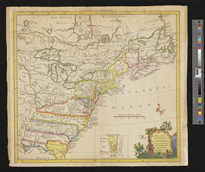
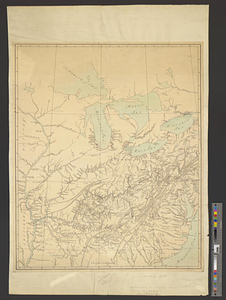
North America east of the Mississippi, ca. 1790
This map is also available in American Revolutionary Geographies Online (ARGO), a collections portal especially built for material relating to the American Revolutionary War Era. Visit ARGO to learn more about this item and explore the historical geography of North America in the late eighteenth century.
Item Information
- Title:
- North America east of the Mississippi, ca. 1790
- Date:
-
[ca. 1790]
- Format:
-
Maps/Atlases
- Genre:
-
Manuscript maps
- Location:
- William L. Clements Library
- Collection (local):
-
William L. Clements Library Collection
- Subjects:
-
East (U.S.)--Maps
Canada, Eastern--Maps
- Places:
-
Eastern United States (area)
Canada
- Extent:
- 1 ms. map : col. ; 57.2 x 46 cm
- Terms of Use:
-
The University of Michigan Library provides access to these materials for educational and research purposes. These materials may be under copyright. If you decide to use any of these materials, you are responsible for making your own legal assessment and securing any necessary permission. If you have questions about the collection, please contact the William L. Clements Library.
Contact host institution for more information.
- Scale:
-
Scale ca. 1:3,200,000.
- Language:
-
English
- Catalog Record:
-
Catalog record
- Notes:
-
Finished, colored, topographical map showing that part of North America from Cape Fear to the Great Lakes and noting towns, forts, and holdings of various land companies.
Great Lakes labelled as seas.
- Identifier:
-
8697
- Barcode:
-
B1941023