Toggle navigation
LMEC Home
Exhibitions
Georeferencing
Tools for Teachers
Collections
My Favorites
Sign Up / Log In
Search
Search the map portal
Map Collection
Map Collection
Map Sets
Search
Search
Search for
Search In
All Fields
Creator
Title
Subject
Place
Search All Digital Collections
Advanced Search
925 Results
My Search
Start Over
More Like
commonwealth-oai:2n49z224v
Remove constraint More Like: commonwealth-oai:2n49z224v
Filter your Search
Place
North and Central America
899
United States
638
Canada
207
New York
192
Quebec
111
Pennsylvania
60
New Jersey
54
Nova Scotia
48
more
Place
»
Topic
United States--History--Revolution, 1775-1783--Maps
305
United States--History--French and Indian War, 1754-1763--Maps
149
Saint Lawrence River--Maps
43
Newport (R.I.)--Maps
27
New York (State)--Maps
24
Hudson River (N.Y. and N.J.)--Maps
21
Québec (Québec)--Maps
21
Louisbourg (N.S.)--Maps
20
more
Topic
»
Date
Date range begin
–
Date range end
Current results range from
1700
to
1965
View distribution
Creator
Rocque, Mary Ann
29
Bellin, Jacques Nicolas, 1703-1772
25
Holland, Samuel, 1728-1801
25
Montrésor, John, 1736-1799
25
Jefferys, Thomas, -1771
24
Clinton, Henry, Sir, 1738?-1795
19
Robert Sayer and John Bennett (Firm)
15
Hills, John, active 1777-1819
13
more
Creator
»
Format
Maps/Atlases
909
Drawings/Illustrations
11
Documents
5
Prints
1
Georeferenced
Yes
3
No
922
Collection
American Revolutionary War-Era Maps
911
William L. Clements Library Collection
909
Norman B. Leventhal Map & Education Center Collection
14
American Antiquarian Society Collection
2
Applied Geographics, Inc. Records
1
Maritime Charts and Atlases
1
Available to use
No known restrictions
14
Search Constraints
Sort by relevance
relevance
title
date (asc)
date (desc)
Number of results to display per page
20 per page
10
per page
20
per page
50
per page
100
per page
View results as:
grid view
map view
Search Results
21.
Map ninth division railway mail service
22.
Map of Atlantic & Pacific Rail Road
23.
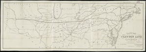
Map of the Clinton Line Railroad and its connections
24.
Map of the Fort Wayne, Lacon, & Platte Valley Air Line Railroad, with its eastern connections and proposed extension west in...
25.
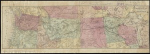
Map of the Northern Pacific R.R. its connections and tributary country
26.
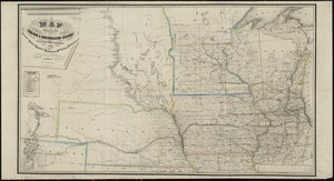
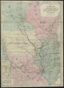
Map of the states of Ohio, Indiana and Illinois with the settled parts of Michigan & Wisconsin
27.
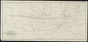
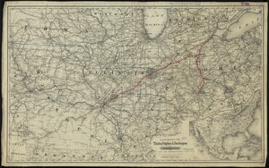
Map showing location of the Chicago & Northwestern Railway with its branches & connections through Illinois, Iowa, Nebraska,...
28.
Map showing the Burlington, Cedar Rapids and Minnesota Railway and its connections
29.
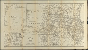
Map sixth division railway mail service
30.
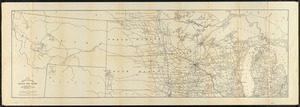
Map tenth division railway mail service
31.
Maps showing the Toledo, Delphos & Burlington Railroad and its connections
32.
15 lots of 440a each in Great Lot no. 4 of Macomb purchase : 6600 acres within 2 miles of the St. Lawrence Turnpike & 1/2 mile...
33.
The above is a connection of the three surveys which I have been able to make on Peters Creek, of yours to gether with John...
34.
An accurate map of New York in North America from a late survey
35.
An accurate map of the British empire in Nth. America as settled by the preliminaries in 1762
36.
An accurate map of the island of St. Christophers, from an actual survey; shewing the parishes, churches; and rivers; also the...
37.
An accurate map of the West Indies : exhibiting not only all the islands possess'd by the English, French, Spaniards & Dutch...
38.
An accurate map of the West Indies, containing the Bahama & Caribbe islands the Great & Little Antilles; with the Leward and...
39.
Action between Genl. St Clairs army & that of the American Indians Novr. 4th 1791 : collected from his public letter
40.
Admiral George Clinton's lands in the "Oblong"
‹ Prev
Next ›
1
2
3
4
5
6
…
46
47