Toggle navigation
LMEC Home
Exhibitions
Georeferencing
Tools for Teachers
Collections
My Favorites
Sign Up / Log In
Search
Search the map portal
Map Collection
Map Collection
Map Sets
Search
Search
Search for
Search In
All Fields
Creator
Title
Subject
Place
Search All Digital Collections
Advanced Search
1131 Results
My Search
Start Over
More Like
commonwealth-oai:0c487j87n
Remove constraint More Like: commonwealth-oai:0c487j87n
Filter your Search
Place
North and Central America
1,101
United States
817
Canada
259
New York
253
New England
124
Quebec
116
Pennsylvania
70
Massachusetts
63
more
Place
»
Topic
United States--History--Revolution, 1775-1783--Maps
306
United States--History--French and Indian War, 1754-1763--Maps
162
New England--Maps
127
New York (State)--Maps
85
Canada--Maps
55
Railroads--New England--Maps
50
Saint Lawrence River--Maps
43
United States--Maps
36
more
Topic
»
Date
Date range begin
–
Date range end
Current results range from
1700
to
2015
View distribution
Creator
Jefferys, Thomas, -1771
29
Rocque, Mary Ann
29
Bellin, Jacques Nicolas, 1703-1772
26
Holland, Samuel, 1728-1801
26
Montrésor, John, 1736-1799
25
Clinton, Henry, Sir, 1738?-1795
19
Robert Sayer and John Bennett (Firm)
17
Orme, Robert, -1781
14
more
Creator
»
Format
Maps/Atlases
1,115
Drawings/Illustrations
11
Documents
5
Manuscripts
3
Prints
1
Georeferenced
Yes
29
No
1,102
Collection
American Revolutionary War-Era Maps
954
William L. Clements Library Collection
909
Norman B. Leventhal Map & Education Center Collection
177
Boston and New England Maps
80
American Antiquarian Society Collection
25
MacLean Collection Map Library
7
David Judkins Weaver Papers
4
Richard H. Brown Revolutionary War Map Collection at Mount Vernon
4
more
Collection
»
Available to use
No known restrictions
179
Creative Commons license
7
Search Constraints
Sort by relevance
relevance
title
date (asc)
date (desc)
Number of results to display per page
20 per page
10
per page
20
per page
50
per page
100
per page
View results as:
grid view
map view
Search Results
281.
The tourist's map of the state of New York : compiled from the latest authorities in the Surveyor General's office
282.
Transportation map of New York
283.
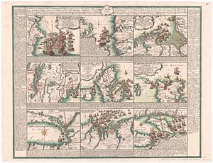
Karte derer englischen unternehmungen zur zee aus denen franzosischen kusten ... = Carte des entrep: anglo:ises par mer sur les...
284.
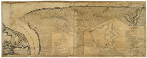
Plan of Niagara with the adjacent country surrendered to the English army under the command of Sr. Willm: Johnson Bart: on the...
285.
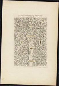
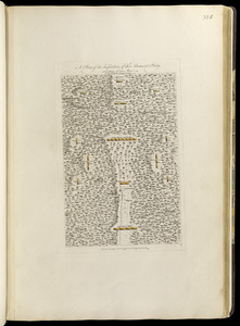
A plan of the disposition of the advanced party consisting of 400 men : to defend the workers in making the road
286.
A plan of the disposition of the advanced party consisting of 400 men : to defend the workers in making the road
287.
A plan of the encampment of the detachment from the little Meadows
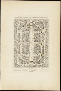
288.
A plan of the encampment of the detachment from the little Meadows
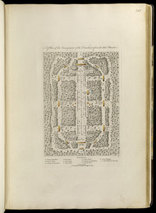
289.
A plan of the line of march of the detachment from the little Meadows
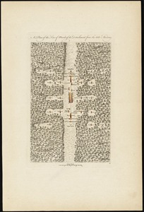
290.
A plan of the line of march of the detachment from the little Meadows
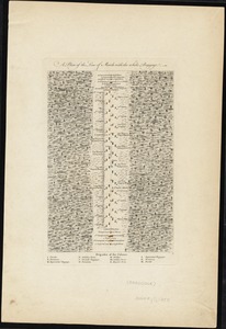
291.
A plan of the line of march with the whole baggage
292.
A plan of the line of march with the whole baggage
293.
Plan of the town of Quebec, the capital of Canada in North America, with the Bason and a part of the adjacent country shewing...
294.
ABC pathfinder railway guide map : eastern division
295.
Automobile map of New England showing the ideal tour
296.
Black in New England 1840
297.
Boston Clinton Fitchburg and Mansfield Framingham Lowell Railroads, and connections
298.
The Boston Globe ski map of northern New England and Canada
299.
A canoeist's guide to New England's rivers
300.
Carte du theatre de la guerre presente en Amerique
‹ Prev
Next ›
1
2
…
11
12
13
14
15
16
17
18
19
…
56
57