Toggle navigation
LMEC Home
Exhibitions
Georeferencing
Tools for Teachers
Collections
My Favorites
Sign Up / Log In
Search
Search the map portal
Map Collection
Map Collection
Map Sets
Search
Search
Search for
Search In
All Fields
Creator
Title
Subject
Place
Search All Digital Collections
Advanced Search
441 Results
My Search
Start Over
More Like
commonwealth:z603vv806
Remove constraint More Like: commonwealth:z603vv806
Filter your Search
Place
North and Central America
367
United States
300
New England
97
Canada
48
New York
44
Middle Atlantic
40
North America
39
Suffolk (county)
38
more
Place
»
Topic
New England--Maps--Early works to 1800
97
Middle Atlantic States--Maps--Early works to 1800
38
United States--History--Revolution, 1775-1783--Maps--Early works to 1800
38
North America--Maps--Early works to 1800
27
Northeastern States--Maps--Early works to 1800
19
Boston (Mass.)--History--Revolution, 1775-1783--Maps--Early works to 1800
18
United States--Maps--Early works to 1800
15
Indians of North America--Maps--Early works to 1800
14
more
Topic
»
Date
Date range begin
–
Date range end
Current results range from
1617
to
1999
View distribution
Creator
Jefferys, Thomas, -1771
38
Faden, William, 1749-1836
36
Le Rouge, Georges-Louis
24
Sayer, Robert, 1725-1794
24
Des Barres, Joseph F. W. (Joseph Frederick Wallet), 1722-1824
22
Jefferys, Thomas, d. 1771
14
Robert Sayer and John Bennett (Firm)
12
Korn, Christoph Heinrich, 1726-1783
10
more
Creator
»
Format
Maps/Atlases
398
Prints
32
Manuscripts
27
Drawings/Illustrations
9
Books
2
Georeferenced
Yes
21
No
420
Collection
American Revolutionary War-Era Maps
386
Richard H. Brown Revolutionary War Map Collection at Mount Vernon
293
Norman B. Leventhal Map & Education Center Collection
89
Boston and New England Maps
37
Mapping Boston Collection
24
MacLean Collection Map Library
15
Maritime Charts and Atlases
15
Sidney R. Knafel Map Collection at Phillips Academy
15
more
Collection
»
Available to use
Creative Commons license
337
No known restrictions
69
Search Constraints
Sort by relevance
relevance
title
date (asc)
date (desc)
Number of results to display per page
20 per page
10
per page
20
per page
50
per page
100
per page
View results as:
grid view
map view
Search Results
21.
Novi Belgii Novaeqve Angliae nec non partis Virginiae Tabula
22.
Pas caerte van Nieu Nederlandt en de Engelsche Virginies van Cabo Cod tot Cabo Canrick
23.
Recens edita totius Novi Belgii in America Septentrionali siti
24.
L'Amerique Septentrionale
25.
Theodolite's pattern, shewing the provinces in North America which were in the respective possessions of England, France &...
26.
Carte de l'Amérique Septle. pour servir à l'intelligence de la guerre entre les Anglois et les insurgents
27.
Carte des Etats-Unis d'Amérique, et du cours du Mississippi : rédigée d'après différentes cartes et relations Anglaises et...
28.
Carte des Etats-Unis de l'Amerique suivant le Traité de Paix de 1783
29.
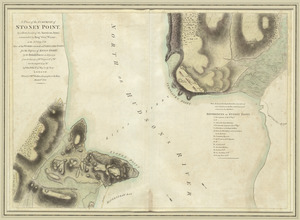
A plan of the surprise of Stoney Point, by a detachment of the American army commanded by Brigr. Genl. Wayne, on the 15th July...
30.
Suite du theatre de la guerre dans l'Amérique Septentrionale y compris le Golfe du Méxique
31.
Théatre de la guerre en Amerique, avec les Isles Antilles : projetté et assujettie aux observations
32.
A map of the most inhabited part of Virginia containing the whole province of Maryland with part of Pensilvania, New Jersey and...
33.
Position der Koenigl;Grosbrittanischen und derer vereinigten provinzial armée in New York und dem Jerseys in Nord America im...
34.
Karte von dem Ostlichen-Stucke von Neu Franckreich oder Canada in America : besonders aber Acadia und Neu Schottland
35.
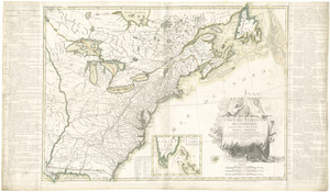
A map of the most inhabited part of New England : containing the provinces of Massachusets Bay and New Hampshire, with the...
36.
A new map of Nova Scotia, and Cape Britain : with the adjacent parts of New England and Canada, composed from a great number of...
37.
Plan des jenigen treffen welches am 8. Sept 1755. zwischen dem Engl. Gen. Johnson, und dem Franz. Gen. Diesckau welcher dabey...
38.
Schauplatz des Kriegs zwischen Engelland und seinen Collonien in America
39.
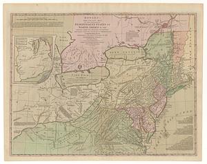
Bowles's new pocket map of the following independent states of North America, viz. Virginia, Maryland, Delaware, Pensylvania,...
40.
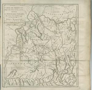
Carte de Kentucke, d'apres les observations actuelles : dediee a l'honorable Congres des Etats-Unis de l'Amerique et a son...
‹ Prev
Next ›
1
2
3
4
5
6
…
22
23