Toggle navigation
LMEC Home
Exhibitions
Georeferencing
Tools for Teachers
Collections
My Favorites
Sign Up / Log In
Search
Search the map portal
Map Collection
Map Collection
Map Sets
Search
Search
Search for
Search In
All Fields
Creator
Title
Subject
Place
Search All Digital Collections
Advanced Search
441 Results
My Search
Start Over
More Like
commonwealth:z603vv806
Remove constraint More Like: commonwealth:z603vv806
Filter your Search
Place
North and Central America
367
United States
300
New England
97
Canada
48
New York
44
Middle Atlantic
40
North America
39
Suffolk (county)
38
more
Place
»
Topic
New England--Maps--Early works to 1800
97
Middle Atlantic States--Maps--Early works to 1800
38
United States--History--Revolution, 1775-1783--Maps--Early works to 1800
38
North America--Maps--Early works to 1800
27
Northeastern States--Maps--Early works to 1800
19
Boston (Mass.)--History--Revolution, 1775-1783--Maps--Early works to 1800
18
United States--Maps--Early works to 1800
15
Indians of North America--Maps--Early works to 1800
14
more
Topic
»
Date
Date range begin
–
Date range end
Current results range from
1617
to
1999
View distribution
Creator
Jefferys, Thomas, -1771
38
Faden, William, 1749-1836
36
Le Rouge, Georges-Louis
24
Sayer, Robert, 1725-1794
24
Des Barres, Joseph F. W. (Joseph Frederick Wallet), 1722-1824
22
Jefferys, Thomas, d. 1771
14
Robert Sayer and John Bennett (Firm)
12
Korn, Christoph Heinrich, 1726-1783
10
more
Creator
»
Format
Maps/Atlases
398
Prints
32
Manuscripts
27
Drawings/Illustrations
9
Books
2
Georeferenced
Yes
21
No
420
Collection
American Revolutionary War-Era Maps
386
Richard H. Brown Revolutionary War Map Collection at Mount Vernon
293
Norman B. Leventhal Map & Education Center Collection
89
Boston and New England Maps
37
Mapping Boston Collection
24
MacLean Collection Map Library
15
Maritime Charts and Atlases
15
Sidney R. Knafel Map Collection at Phillips Academy
15
more
Collection
»
Available to use
Creative Commons license
337
No known restrictions
69
Search Constraints
Sort by relevance
relevance
title
date (asc)
date (desc)
Number of results to display per page
20 per page
10
per page
20
per page
50
per page
100
per page
View results as:
grid view
map view
Search Results
361.
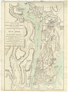
A plan of the operations of the King's army under the command of General Sr. William Howe, K.B. in New York and east New Jersey...
362.
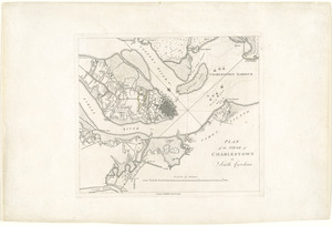
Plan of the siege of Charlestown in South Carolina
363.
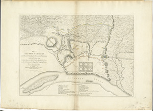
Plan of the siege of Savannah : with the joint attack of the French and Americans on the 9th October 1779 : in which they were...
364.
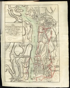
Plan of the situation of the American & British armies, June 15st 1777
365.
A plan of the town of Boston with the intrenchments & ca. of His Majesty's forces in 1775 : from the observations of Lieut....
366.
A plan of the town of Boston, with the intrenchments &c. of His Majestys forces in 1775 : from the observations of Lieut. Page...
367.
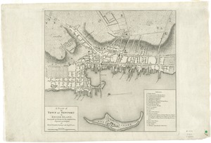
A plan of the town of Newport in Rhode Island
368.
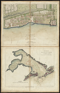
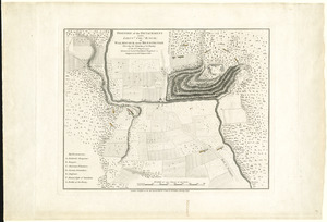
Plan of the town of St. Augustine, the capital of East Florida ; The bay of Espiritu Santo, on the western coast of East Florida
369.
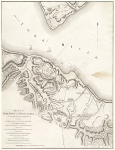
A plan of York Town and Gloucester, in the province of Virginia, shewing the works constructed for the defence of those posts...
370.
Plan von den operationen der Koeniglichen Armee unter dem General Sir William Howe : in Neuyorck und Ost-Neujerseÿ gegen die...
371.
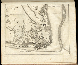
Plan von Quebec
372.
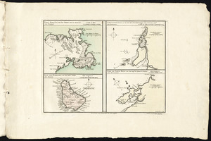
Port, baye cul de sac Royal dans la Martinique -- Isle des Barbades une des Isles Antilles -- Cartagene située sur le Côte de...
373.
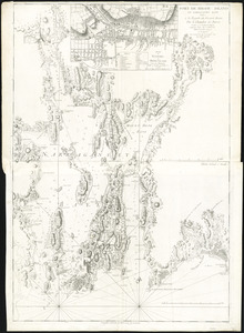
Port de Rhode Island et Narraganset Baye : publié à la requête du Vicomte Howe par le Chevalier des Barres ; traduit de...
374.
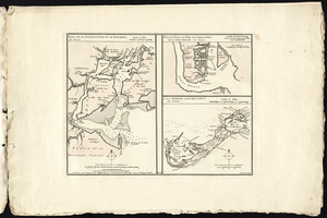
Port de St. Augustin -- Port de la Providence -- La Havane dans l'isle de Cuba -- Baye de Sn. Iago dans l'isle de Cuba -- Port...
375.
Ports de la Nouvelle York et de Pertamboy -- Plan de la ville et du port de Charles Town dans la Caroline Méridionale -- I. de...
376.
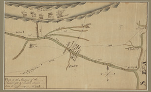
Position of the detachment under Lieut. Col. Baum, at Walmscock near Bennington shewing the attacks of the enemy on the 16th...
377.
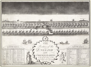
The position of the English and French fleets on the 12th of April 1782 at 10 oclock in the morning
378.
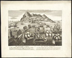
La premiere representation de les X batteries flottantes
379.
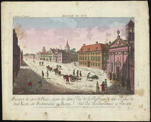
Prospect der grossen plazes gegn der alten Sud Kirche der Presbiterianer zu Boston = : Vuë de la Rue grande vers l'Eglise du...
380.
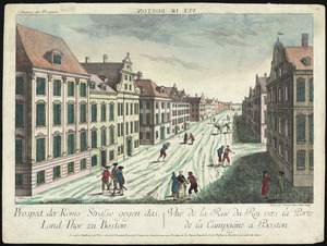
Prospect der König Strasse gegen das land thor zu Boston = : Vuë de la Rue du Roi vers la porte de la campagne a Boston
‹ Prev
Next ›
1
2
…
15
16
17
18
19
20
21
22
23