Toggle navigation
LMEC Home
Exhibitions
Georeferencing
Tools for Teachers
Collections
My Favorites
Sign Up / Log In
Search
Search the map portal
Map Collection
Map Collection
Map Sets
Search
Search
Search for
Search In
All Fields
Creator
Title
Subject
Place
Search All Digital Collections
Advanced Search
312 Results
My Search
Start Over
More Like
commonwealth:z603vv742
Remove constraint More Like: commonwealth:z603vv742
Filter your Search
Place
North and Central America
245
United States
177
North America
35
Canada
33
New York
31
Suffolk (county)
31
Boston
29
Charleston (county)
10
more
Place
»
Topic
North America--Maps--Early works to 1800
20
Boston (Mass.)--History--Revolution, 1775-1783--Maps--Early works to 1800
16
Indians of North America--Maps--Early works to 1800
14
United States--History--Revolution, 1775-1783--Maps--Early works to 1800
13
North America--History--Revolution, 1775-1783--Maps--Early works to 1800
10
United States--Maps--Early works to 1800
10
Vues d'optique
10
Gibraltar--History--Siege, 1779-1783--Maps--Early works to 1800
9
more
Topic
»
Date
Date range begin
–
Date range end
Current results range from
1730
to
1850
View distribution
Creator
Faden, William, 1749-1836
33
Jefferys, Thomas, -1771
31
Le Rouge, Georges-Louis
23
Des Barres, Joseph F. W. (Joseph Frederick Wallet), 1722-1824
21
Sayer, Robert, 1725-1794
21
Robert Sayer and John Bennett (Firm)
11
Korn, Christoph Heinrich, 1726-1783
10
Raspe, Gabriel Nicolaus, 1712-1785
10
more
Creator
»
Format
Maps/Atlases
269
Prints
32
Manuscripts
25
Drawings/Illustrations
9
Books
2
Georeferenced
Yes
12
No
300
Collection
American Revolutionary War-Era Maps
308
Richard H. Brown Revolutionary War Map Collection at Mount Vernon
293
Norman B. Leventhal Map & Education Center Collection
11
MacLean Collection Map Library
5
Boston and New England Maps
4
Maritime Charts and Atlases
2
Newberry Library Collection
2
Urban Maps
2
more
Collection
»
Available to use
Creative Commons license
293
No known restrictions
12
Search Constraints
Sort by relevance
relevance
title
date (asc)
date (desc)
Number of results to display per page
20 per page
10
per page
20
per page
50
per page
100
per page
View results as:
grid view
map view
Search Results
1.
Allgemeine charte von Nord America als den sitz des krieges zwischen den Konigl. Engl. truppen u:den provinzialen
2.
Théatre de la guerre en Amerique, avec les Isles Antilles : projetté et assujettie aux observations
3.
Carte generale des colonies angloises dans l'Amerique Septentrionale pour l'intelligence de la guerre presente : d'apres des...
4.
Karte von Neu England, Neu Yorck und Pensilvanien
5.
Theodolite's pattern, shewing the provinces in North America which were in the respective possessions of England, France &...
6.
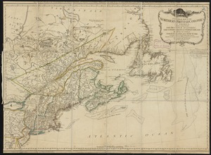
A general map of the northern British Colonies in America : which comprehends the province of Quebec, the government of...
7.
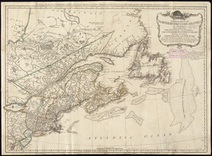
A general map of the northern British colonies in America : which comprehends the province of Quebec, the government of...
8.
A new and accurate map of the present seat of war in North America
9.
A new map of the British colonies in North America, shewing the seat of the present war, taken from the best surveys, compared...
10.
Theatre de la guerre en Amerique
11.
Théatre de la guerre en Amerique, avec les Isles Antilles : projetté et assujettie aux observations
12.
Théatre de la guerre en Amerique, avec les Isles Antilles : projetté et assujettie aux observations
13.
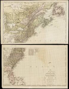
The theatre of war in North America, with the roads, and tables, of the superficial contents, distances, &ca
14.
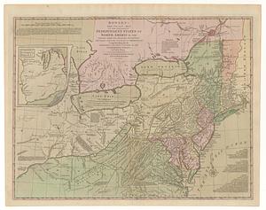
Bowles's new pocket map of the following independent states of North America, viz. Virginia, Maryland, Delaware, Pensylvania,...
15.
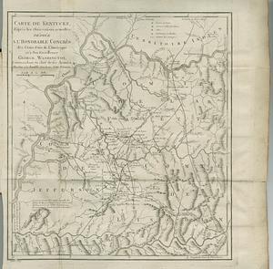
Carte de Kentucke, d'apres les observations actuelles : dediee a l'honorable Congres des Etats-Unis de l'Amerique et a son...
16.
Carte du Canada ou de la Nouvelle France et des decouvertes qui y ont été faites
17.
Carte von America
18.
Copy of a map presented to the Congres [sic]
19.
Cours de l'Ohio depuis sa source jusqu'a sa jonction avec la Riviere d'Ouabache et les pais voisons
20.
Florida from the latest authorities
‹ Prev
Next ›
1
2
3
4
5
…
15
16


![Copy of a map presented to the Congres [sic]](https://bpldcassets.blob.core.windows.net/derivatives/images/commonwealth:z603vn16x/image_thumbnail_300.jpg)

