Toggle navigation
LMEC Home
Exhibitions
Georeferencing
Tools for Teachers
Collections
My Favorites
Sign Up / Log In
Search
Search the map portal
Map Collection
Map Collection
Map Sets
Search
Search
Search for
Search In
All Fields
Creator
Title
Subject
Place
Search All Digital Collections
Advanced Search
69 Results
My Search
Start Over
More Like
commonwealth:z603vq348
Remove constraint More Like: commonwealth:z603vq348
Filter your Search
Place
North and Central America
69
United States
49
New York
48
New Jersey
33
Pennsylvania
10
New England
8
Northeastern United States
7
Middle Atlantic
4
more
Place
»
Topic
New Jersey--Maps--Early works to 1800
34
New York (State)--Maps--Early works to 1800
34
Pennsylvania--Maps--Early works to 1800
10
New Jersey--Administrative and political divisions--Maps--Early works to 1800
9
New England--Maps--Early works to 1800
8
Northeastern States--Maps--Early works to 1800
8
New York (State)--Administrative and political divisions--Maps--Early works to 1800
6
Middle Atlantic States--Maps--Early works to 1800
5
more
Topic
»
Date
Date range begin
–
Date range end
Current results range from
1636
to
1845
View distribution
Creator
Faden, William, 1749-1836
11
Bancker, Gerard, 1740-1799
5
Ratzer, Bernard
5
Sauthier, Claude Joseph
5
Kitchin, Thomas, 1719-1784
4
Le Rouge, Georges-Louis
4
Montrésor, John, 1736-1799
4
Dury, Andrew
3
more
Creator
»
Format
Maps/Atlases
69
Manuscripts
2
Georeferenced
Yes
6
No
63
Collection
American Revolutionary War-Era Maps
54
New York Public Library Collection
27
Norman B. Leventhal Map & Education Center Collection
20
MacLean Collection Map Library
9
Richard H. Brown Revolutionary War Map Collection at Mount Vernon
8
Sidney R. Knafel Map Collection at Phillips Academy
4
Maritime Charts and Atlases
3
Urban Maps
3
more
Collection
»
Available to use
Creative Commons license
38
No known restrictions
18
Search Constraints
Sort by relevance
relevance
title
date (asc)
date (desc)
Number of results to display per page
20 per page
10
per page
20
per page
50
per page
100
per page
View results as:
grid view
map view
Search Results
41.
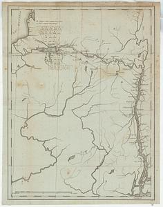
A chorographical map of the Province of New-York in North America, divided into counties, manors, patents and townships :...
42.
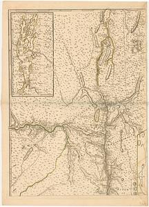
A chorographical map of the Province of New-York in North America, divided into counties, manors, patents and townships :...
43.
Karte von Neu England, Neu Yorck und Pensilvanien : sur Allgemeinen historie der reisen
44.
Lauff des flusses St. Laurentzi von Quebec bis an den See Ontario : 2. bladt
45.
A map of New England and New York
46.
A map of the country of the Five Nations, belonging to the province of New York; and of the lakes near which the nations of far...
47.
A map of the inhabited part of Canada from the French surveys : with the frontiers of New York and New England from the large...
48.
A map of the inhabited part of Canada from the French surveys : with the frontiers of New York and New England from the large...
49.
A map of the province of New York, with part of Pensilvania, and New England
50.
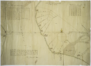
A map of Tottin & Crosfields purchase & the waters adjacent in the state of New-York
51.
Map of western New York state, marking land plots around Lac Oneida
52.
New England and New York
53.
Noua Anglia, Nouum Belgium, et Virginia
54.
Nouvelle Angleterre et Nouvel York
55.
Pas caert van Nieu Nederland, Virginia en Nieu Engelant
56.
Province de New-York en 4. feuilles par Montresor
57.
The southern part of the Province of New York : with part of the adjoining colonies
58.
The state of New York, compiled from the most authentic information, 1796
59.
Map of a tract of land called the Nyack Patent lying within the limits of the town of New Utrecht in the County of Kings
60.
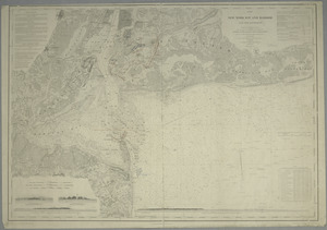
Map of New-York Bay and Harbor and the environs : [with colored manuscript additions to show positions of troops and fleets at...
‹ Prev
Next ›
1
2
3
4