Toggle navigation
LMEC Home
Exhibitions
Georeferencing
Tools for Teachers
Collections
My Favorites
Sign Up / Log In
Search
Search the map portal
Map Collection
Map Collection
Map Sets
Search
Search
Search for
Search In
All Fields
Creator
Title
Subject
Place
Search All Digital Collections
Advanced Search
79 Results
My Search
Start Over
More Like
commonwealth:z603vn885
Remove constraint More Like: commonwealth:z603vn885
Filter your Search
Place
South America
58
Mesoamerica
56
North America
56
North and Central America
51
America
50
Americas
10
Atlantic Ocean
3
Asia
2
more
Place
»
Topic
America--Maps--Early works to 1800
78
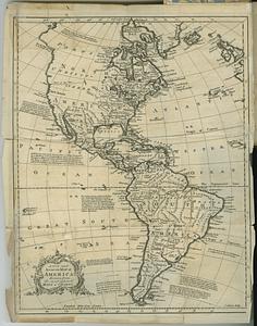
Western Hemisphere--Maps--Early works to 1800
50
North America--Maps--Early works to 1800
3
Pacific Ocean--Maps--Early works to 1800
3
South America--Maps--Early works to 1800
3
World maps--Early works to 1800
3
Asia--Maps--Early works to 1800
2
Atlantic Ocean--Maps--Early works to 1800
2
more
Topic
»
Date
Date range begin
–
Date range end
Current results range from
1520
to
1802
View distribution
Creator
Ortelius, Abraham, 1527-1598
6
Danckerts, Justus, 1635-1701
3
L'Isle, Guillaume de, 1675-1726
3
Speed, John, 1552?-1629
3
Wit, Frederik de.
3
Aa, Pieter van der, 1659-1733
2
Allard, Carel, 1648-ca. 1709
2
Allard, Huych, 1625-1691
2
more
Creator
»
Format
Maps/Atlases
79
Georeferenced
Yes
2
No
77
Collection
Norman B. Leventhal Map & Education Center Collection
58
American Revolutionary War-Era Maps
16
Sidney R. Knafel Map Collection at Phillips Academy
9
MacLean Collection Map Library
6
New York Public Library Collection
4
Mapping Boston Collection
3
Richard H. Brown Revolutionary War Map Collection at Mount Vernon
2
Available to use
No known restrictions
55
Creative Commons license
9
Search Constraints
Sort by relevance
relevance
title
date (asc)
date (desc)
Number of results to display per page
20 per page
10
per page
20
per page
50
per page
100
per page
View results as:
grid view
map view
Search Results
41.
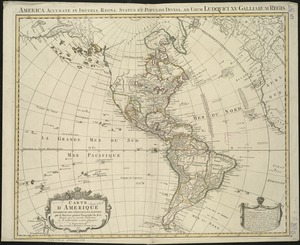
Carte d'Amerique divisées en ses principales parties
42.
Carte du Gouvernement de l'Amerique
43.
Carte von America
44.
A chart of North and South America, including the Atlantic and Pacific Oceans, with the nearest coasts of Europe, Africa and Asia
45.
Chart of the track of the Dolphin, Tamar, Swallow & Endeavour through the South Seas ; & of the track of M. Bougainville round...
46.
The Earth's Western planisphere
47.
La Florida
48.
Mappa fluxus et refluxus rationes in isthmo Americano, in Freto Magellanico, cæterisque Americæ litoribus exhibens
49.
Maris Pacifici (quod vulgo Mar del Zur) cum regionibus circumiacentibus, insulisque in eodem passim sparsis, novissima descriptio
50.
Maris Pacifici (quod vulgo Mar del Zur) cum regionibus circumiacentibus, insulisque in eodem passim sparsis, novissima descriptio
51.
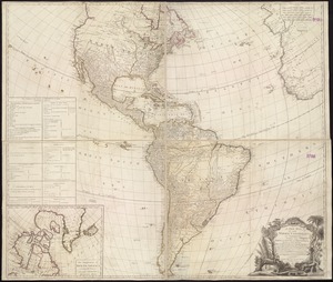
A new and accurate map of America, drawn from the most approv'd maps & charts
52.
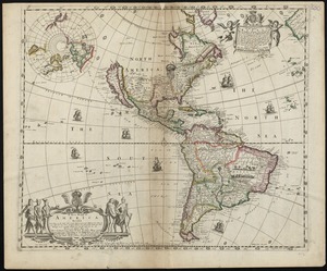
A new general map of America
53.
A new map containing the English Empire Golf of Mexico Caribes Islands Granada Guiana Amazone and Peru
54.
A new map of America from the latest observations
55.
A new map of the whole continent of America, divided into North and South and West Indies : wherein are exactly described the...
56.
A new mapp of America devided according to the best and latest observations and discoveries wherein are described by thear...
57.
A new, plaine, and exact map of America : described by N.I. Visscher, and don into English, enlarged, and corrected, according...
58.
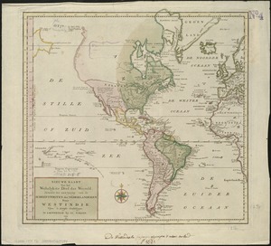
Nieuwe kaart van America uitgegeven te Amsterdam
59.
Nieuwe kaart van het westelykste deel der weereld, dienende tot aanwyzing van de scheepstogten der Nederlanderen naar Westindie...
60.
Noua et accurata totius Americae tabula
‹ Prev
Next ›
1
2
3
4