Toggle navigation
LMEC Home
Exhibitions
Georeferencing
Tools for Teachers
Collections
My Favorites
Sign Up / Log In
Search
Search the map portal
Map Collection
Map Collection
Map Sets
Search
Search
Search for
Search In
All Fields
Creator
Title
Subject
Place
Search All Digital Collections
Advanced Search
154 Results
My Search
Start Over
More Like
commonwealth:z603vm97x
Remove constraint More Like: commonwealth:z603vm97x
Filter your Search
Place
North and Central America
133
United States
72
Canada
22
Saint Lawrence River
11
San Juan
8
Florida
7
Mississippi
7
Quebec
7
more
Place
»
Topic
Manuscript maps--Early works to 1800
138
Nautical charts--Saint Lawrence River--Early works to 1800
8
Saint Lawrence River Valley--Maps--Early works to 1800
7
Saint Lawrence River--Maps--Early works to 1800
7
Añasco (P.R.)--Maps--Early works to 1800
6
Coasts--Florida--Maps--Early works to 1800
6
Coasts--Puerto Rico--Añasco--Maps--Early works to 1800
6
Coasts--Puerto Rico--Mayagüez--Maps--Early works to 1800
6
more
Topic
»
Date
Date range begin
–
Date range end
Current results range from
1613
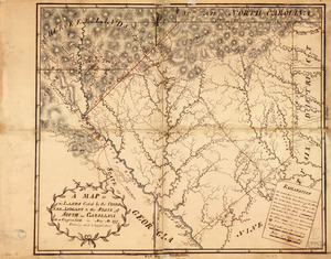
to
1899
View distribution
Creator
Dumont de Montigny
14
Adlum, John, 1759-1836
9
Bingham, William, 1752-1804
9
Des Barres, Joseph F. W. (Joseph Frederick Wallet), 1722-1824
5
De Brahm, John Gerar William, 1717-approximately 1799
4
Jefferys, Thomas, -1771
4
Norman, John, 1748?-1817
4
Real Escuela de Navegación (Cádiz, Spain)
4
more
Creator
»
Format
Maps/Atlases
154
Manuscripts
139
Georeferenced
Yes
2
No
152
Collection
American Revolutionary War-Era Maps
142
Library of Congress Collection
97
Newberry Library Collection
39
Maritime Charts and Atlases
25
Norman B. Leventhal Map & Education Center Collection
16
Urban Maps
8
Boston and New England Maps
4
Harvard Map Collection
1
more
Collection
»
Available to use
Creative Commons license
100
No known restrictions
15
Search Constraints
Sort by relevance
relevance
title
date (asc)
date (desc)
Number of results to display per page
20 per page
10
per page
20
per page
50
per page
100
per page
View results as:
grid view
map view
Search Results
61.
Descripción ychonográfica de la ciudad, puerto y bahía de Santiago de Cuba situado en 20⁰6ʹ de latitud norte y en longd. de...
62.
Dotted line map of Washington, D.C., 1791, before Aug. 19th
63.
Draft of roads in New Jersey
64.
A draught of Lake George, and part of Hudson's River taken September 1756
65.
Fort Edward to Crown Point
66.
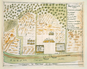
Habitation de l'autheur sur le fleuve
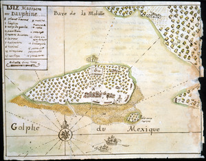
67.
Isle Massacre ou Dauphine
68.
Jefferson, Venango & Armstrong
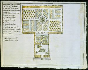
69.
Land ownership map of the William Bingham estate in Potter County, Pennsylvania
70.
Lines run in the Jersies for determining boundaries between that Province & New York
71.
Logement de l'autheur a la Nlle. Orleans
72.
Manuscript survey of a property in Kittery, Maine
73.
Map of part of the city of Washington shewing the situation of the mansion house, grave yard & buildings belonging to Mr....
74.
A map of Potomack and James rivers in North America shewing their several communications with the navigable waters of the new...
75.
Map of the coast of Georgia, bordering on Camden and Glynn counties : showing also the course and soundings of the Alatamaha,...
76.
Map of the country between and bordering the Delaware River and Chesapeake Bay : showing roads to Philadelphia and localities
77.
A Map of the lands ceded by the Cherokee Indians to the State of South-Carolina : at a congress held in May, A.D. 1777;...
78.
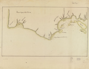
Map showing coast in the regions of Aguadilla, Añasco, and Mayagüez
79.
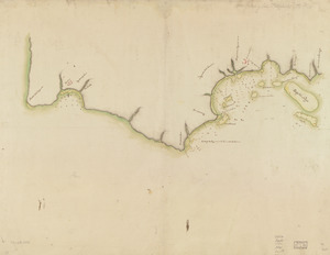
Map showing coast in the regions of Aguadilla, Añasco, and Mayagüez
80.
A map with part of the Florida coast from Cape Blaise to Apalachie : with the boundaries betwixt East & West Floridas, 160...
‹ Prev
Next ›
1
2
3
4
5
6
7
8