Toggle navigation
LMEC Home
Exhibitions
Georeferencing
Tools for Teachers
Collections
My Favorites
Sign Up / Log In
Search
Search the map portal
Map Collection
Map Collection
Map Sets
Search
Search
Search for
Search In
All Fields
Creator
Title
Subject
Place
Search All Digital Collections
Advanced Search
628 Results
My Search
Start Over
More Like
commonwealth:z603vg973
Remove constraint More Like: commonwealth:z603vg973
Filter your Search
Place
North and Central America
583
United States
431
Canada
151
Quebec
73
New York
60
North America
31
Saint Lawrence River
27
West Indies
23
more
Place
»
Topic
United States--Maps
321
United States--History--French and Indian War, 1754-1763--Maps
161
Canada--Maps
55
Elections--United States--Maps
36
Railroads--United States--Maps
34
North America--Maps
30
Saint Lawrence River--Maps
27
West Indies--Maps
24
more
Topic
»
Date
Date range begin
–
Date range end
Current results range from
1750
to
2023
View distribution
Creator
Paullin, Charles Oscar, 1868 or 1869-1944
70
Wright, John Kirtland, 1891-1969
70
Rocque, Mary Ann
24
Jefferys, Thomas, -1771
18
Geological Survey (U.S.)
15
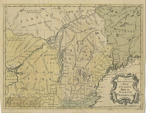
Orme, Robert, -1781
14
Reid, John, 1764?-1828
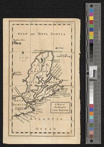
11
Bellin, Jacques Nicolas, 1703-1772
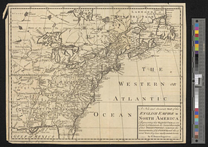
10
more
Creator
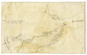
»
Format
Maps/Atlases
625
Manuscripts
13
Prints
3
Books
1
Objects/Artifacts
1
Posters
1
Georeferenced
Yes
77
No
551
Collection
American Revolutionary War-Era Maps
317
Norman B. Leventhal Map & Education Center Collection
314
William L. Clements Library Collection
167
American Antiquarian Society Collection
138
Richard H. Brown Revolutionary War Map Collection at Mount Vernon
4
Boston and New England Maps
3
MacLean Collection Map Library
3
David Judkins Weaver Papers
2
more
Collection
»
Available to use
No known restrictions
240
Creative Commons license
10
Search Constraints
Sort by relevance
relevance
title
date (asc)
date (desc)
Number of results to display per page
20 per page
10
per page
20
per page
50
per page
100
per page
View results as:
grid view
map view
Search Results
81.
Fort Edward to Ticonderoga
82.
Fort Halifax and the Kennebec River : Québec July 25th, 1761
83.
Fort William Henry
84.
French draught of Lake Champlain & Lake George with remarks of an English prisoner who return'd from Quebec to Fort Edward by...
85.
Gabarus Bay
86.
Ein grund-ris von der Festung Duquesne ...
87.
Hudson's River from New York to Albany
88.
Lake Champlain
89.
Lake Megantic and the Chaudière River : Québec July 25th, 1761
90.
Map from Albany to Crown Point
91.
A map of the British and French settlements in North America
92.
Map of the British landings at Louisbourg
93.
A map of the country between Will's Creek & Monongahela River shewing the rout and encampments of the English army, in 1755
94.
A map of the island of Cape Breton
95.
Moosehead Lake and the immediate area to the west : Québec July 25th, 1761
96.
A new and accurate map of the English empire in North America : representing their rightful claim as confirm'd by charters, &...
97.
A new and accurate map of the English empire in North America : representing their rightful claim as confirm'd by charters, and...
98.
A new and accurate map of the present war in North America
99.
Oneida Lake to the Mohawk River
100.
Parish of Batiscant. Parish of St. Pierre Becquet. Parish of Champlain. Parish of Gentilly
‹ Prev
Next ›
1
2
3
4
5
6
7
8
9
…
31
32