Toggle navigation
LMEC Home
Exhibitions
Georeferencing
Tools for Teachers
Collections
My Favorites
Sign Up / Log In
Search
Search the map portal
Map Collection
Map Collection
Map Sets
Search
Search
Search for
Search In
All Fields
Creator
Title
Subject
Place
Search All Digital Collections
Advanced Search
182 Results
My Search
Start Over
More Like
commonwealth:z603vg45b
Remove constraint More Like: commonwealth:z603vg45b
Filter your Search
Place
North and Central America
148
United States
93
New Hampshire
30
Vermont
29
Canada
25
New York
18
North America
17
West Indies
17
more
Place
»
Topic
New Hampshire--Maps
32
Vermont--Maps
29
United States--Maps
21
New England--Maps
17
North America--Maps
17
West Indies--Maps
17
New York (State)--Maps
16
Maine--Maps
15
more
Topic
»
Date
Date range begin
–
Date range end
Current results range from
1750
to
1981
View distribution
Creator
Reid, John, 1764?-1828
11
Farwell, John Whittemore, 1843-1929
9
Bellin, Jacques Nicolas, 1703-1772
8
Kitchin, Thomas, 1719-1784
8
Carleton, Osgood, 1742-1816
6
Tanner, Benjamin, 1775-1848
6
Anderson, Alexander, 1775-1870
5
Gibson, J. (John), active 1750-1792
5
more
Creator
»
Format
Maps/Atlases
182
Manuscripts
12
Georeferenced
Yes
16
No
166
Collection
American Revolutionary War-Era Maps
147
American Antiquarian Society Collection
138
Norman B. Leventhal Map & Education Center Collection
35
Boston and New England Maps
26
William L. Clements Library Collection
7
Applied Geographics, Inc. Records
1
David Judkins Weaver Papers
1
Maritime Charts and Atlases
1
more
Collection
»
Available to use
No known restrictions
35
Creative Commons license
2
Search Constraints
Sort by relevance
relevance
title
date (asc)
date (desc)
Number of results to display per page
20 per page
10
per page
20
per page
50
per page
100
per page
View results as:
grid view
map view
Search Results
41.
Map showing the proposed line of the Manchester Rail Road as petitioned for by S.D. Bell & others
42.
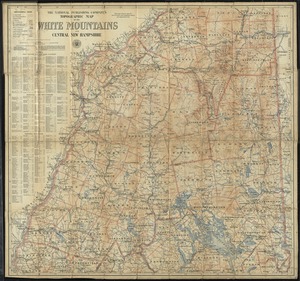
The National Publishing Company's topographic map of the White Mountains and central New Hampshire
43.
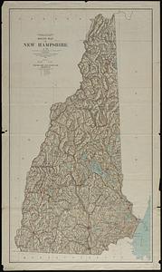
New Hampshire
44.
New Hampshire
45.
New Hampshire by recent survey : made under the supreme authority and published according to law
46.
New-Hampshire : from late survey
47.
Relief map of New Hampshire
48.
The state of New Hampshire
49.
The state of New Hampshire : compiled chiefly from actual surveys
50.
This plan of Kennebeck & Sagadahock Rivers & country adjacent
51.
Topographical map of the province of New Hampshire, including Montresor's survey of the St. Lawrence and the Kennebec route to...
52.
Tri-state trolley map showing Boston & Northern and Old Colony Street Railway Companies' systems and connecting lines
53.
1st. sheet of De Witt's state-map of New York
54.
An accurate map of North America
55.
An accurate map, of the District of Maine : being part of the commonwealth of Massachusetts
56.
An Accurate map of the United States of America. : According to the Treaty of Peace of 1783
57.
An accurate map of the West Indies, : containing the Bahama & Carribe islands, the Great & Little Antilles, with the Leward and...
58.
An accurate map of the West Indies
59.
An Accurate map of the West Indies, with the adjacent coast
60.
An accurate map of the West Indies with the adjacent coast of America
‹ Prev
Next ›
1
2
3
4
5
6
7
…
9
10