Toggle navigation
LMEC Home
Exhibitions
Georeferencing
Tools for Teachers
Collections
My Favorites
Sign Up / Log In
Search
Search the map portal
Map Collection
Map Collection
Map Sets
Search
Search
Search for
Search In
All Fields
Creator
Title
Subject
Place
Search All Digital Collections
Advanced Search
214 Results
My Search
Start Over
More Like
commonwealth:z603vg25v
Remove constraint More Like: commonwealth:z603vg25v
Filter your Search
Place
North and Central America
180
United States
124
Louisiana
36
Southern United States
28
Florida
25
Canada
22
West Indies
19
North America
17
more
Place
»
Topic
Louisiana--Maps
36
Southern States--Maps
29
Florida--Maps
25
United States--Maps
20
West Indies--Maps
19
North America--Maps
17
Canada--Maps
14
Boston (Mass.)--Maps
9
more
Topic
»
Date
Date range begin
–
Date range end
Current results range from
1749
to
1986
View distribution
Creator
Geological Survey (U.S.)
11
Reid, John, 1764?-1828
11
Farwell, John Whittemore, 1843-1929
9
Kitchin, Thomas, 1719-1784
9
United States. Post Office Dept
9
Bellin, Jacques Nicolas, 1703-1772
8
Carleton, Osgood, 1742-1816
6
Tanner, Benjamin, 1775-1848
6
more
Creator
»
Format
Maps/Atlases
214
Manuscripts
12
Georeferenced
Yes
29
No
185
Collection
American Revolutionary War-Era Maps
151
American Antiquarian Society Collection
138
Norman B. Leventhal Map & Education Center Collection
62
William L. Clements Library Collection
11
MacLean Collection Map Library
2
Boston and New England Maps
1
Maritime Charts and Atlases
1
New York Public Library Collection
1
Available to use
No known restrictions
61
Creative Commons license
3
Search Constraints
Sort by relevance
relevance
title
date (asc)
date (desc)
Number of results to display per page
20 per page
10
per page
20
per page
50
per page
100
per page
View results as:
grid view
map view
Search Results
41.
Map of Virginia and West Va., North and part of South Carolina, Maryland and Delaware, showing the situation in these states of...
42.
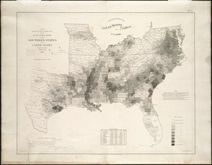
Map showing the distribution of the slave population of the southern states of the United States
43.
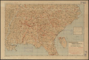
Map third division railway mail service
44.
Military map of the middle and southern states showing the seat of war during the great rebellion in 1861
45.
A new map of the Cherokee nation with the names of the towns & rivers : they are situated on no. lat. from 34 to 36
46.
Perrine's new topographical war map of the southern states : taken from the latest government surveys and official reports
47.
Selected hurricanes affecting the southern United States 1954-1977
48.
Southeast States road map
49.
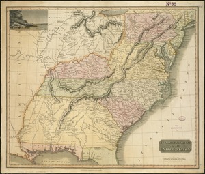
Southern provinces of the United States
50.
Southern States
51.
The United States southern part : from the latest surveys
52.
Where the fight will be centered, if there is one
53.
Baton Rouge
54.
Breton Sound
55.
Carte composée des differens ouvrages de messieurs les ingenieurs qui ont eté à Louisiane, avec les renvois alphabetiques de...
56.
A draught of the river Missisippi. From the Balise to Fort Cavendish : taken in the months of June, July, August, September,...
57.
From Vicksburg to New Orleans
58.
Gallup's map of Louisiana
59.
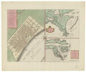
Grondvlakte van Nieuw Orleans, de hoofdstad van Louisiana ; de uitloop van de Rivier Missisippi ; de oostelyke ingang van de...
60.
Louisiana : Chef Menteur sheet
‹ Prev
Next ›
1
2
3
4
5
6
7
…
10
11