Toggle navigation
LMEC Home
Exhibitions
Georeferencing
Tools for Teachers
Collections
My Favorites
Sign Up / Log In
Search
Search the map portal
Map Collection
Map Collection
Map Sets
Search
Search
Search for
Search In
All Fields
Creator
Title
Subject
Place
Search All Digital Collections
Advanced Search
8555 Results
My Search
Start Over
More Like
commonwealth:xg94j1388
Remove constraint More Like: commonwealth:xg94j1388
Filter your Search
Place
North and Central America
5,845
United States
4,769
Massachusetts
2,052
Europe
1,359
Suffolk (county)
1,034
Boston
1,007
Canada
448
Asia
422
more
Place
»
Topic
Boston (Mass.)--Maps
577
United States--Maps
273
Real property--Massachusetts--Boston--Maps
174
Massachusetts--Maps
160
Landowners--Massachusetts--Boston--Maps
132
North America--Maps--Early works to 1800
103
New England--Maps
99
Europe--Maps
78
more
Topic
»
Date
Date range begin
–
Date range end
Current results range from
1482
to
2023
View distribution
Creator
United States. Hydrographic Office
594
O.H. Bailey & Co
148
Des Barres, Joseph F. W. (Joseph Frederick Wallet), 1722-1824
123
United States. Post Office Dept
120
Ptolemy, 2nd cent
100
Walling, Henry Francis, 1825-1888
94
Geological Survey (U.S.)
86
Jefferys, Thomas, -1771
85
more
Creator
»
Format
Maps/Atlases
8,496
Manuscripts
215
Prints
56
Books
36
Objects/Artifacts
10
Drawings/Illustrations
8
Posters
4
Georeferenced
Yes
870
No
7,685
Collection
Norman B. Leventhal Map & Education Center Collection
8,550
Boston and New England Maps
2,204
Urban Maps
1,936
Maritime Charts and Atlases
1,081
American Revolutionary War-Era Maps
620
Boston Redevelopment Authority Collection
87
American Antiquarian Society Collection
4
MacLean Collection Map Library
1
Available to use
No known restrictions
8,409
Creative Commons license
46
Search Constraints
Sort by relevance
relevance
title
date (asc)
date (desc)
Number of results to display per page
20 per page
10
per page
20
per page
50
per page
100
per page
View results as:
grid view
map view
Search Results
21.
Colombie et Guyanes
22.
The good neighbor pictorial map of South America
23.
A map of South America according to the best authorities
24.
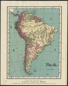
No. 4 : [South America]
25.
Rand, McNally & Co.'s indexed atlas of the world map of South America
26.
South America
27.
South America
28.
South America
29.
South America
30.
South America
31.
South America : reduced from the sheet map
32.
Südamerika
33.
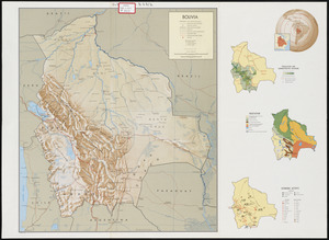
Bolivia
34.
Amérique Méridionale
35.
Map of the European settlements in South America and on the western coast of Africa
36.
Mapa de America sujecto à las observaciones astronomicas
37.
A New map of the whole continent of America, divided into North and South and West Indies. : With a descriptive account of the...
38.
A New map of the whole continent of America, divided into North and South and West Indies. : Wherein are exactly described the...
39.
The 100th anniversary map of Abraham Lincoln's visit to Massachusetts, September 11-23, 1848
40.
1630 shoreline
‹ Prev
Next ›
1
2
3
4
5
6
…
427
428