Toggle navigation
LMEC Home
Exhibitions
Georeferencing
Tools for Teachers
Collections
My Favorites
Sign Up / Log In
Search
Search the map portal
Map Collection
Map Collection
Map Sets
Search
Search
Search for
Search In
All Fields
Creator
Title
Subject
Place
Search All Digital Collections
Advanced Search
394 Results
My Search
Start Over
More Like
commonwealth:x633mn92t
Remove constraint More Like: commonwealth:x633mn92t
Filter your Search
Place
North and Central America
341
United States
217
Canada
73
North America
68
New York
23
Pennsylvania
18
Asia
17
New England
15
more
Place
»
Topic
North America--Maps--Early works to 1800
59
United States--Maps--Early works to 1800
43
Canada--Maps--Early works to 1800
39
Great Lakes Region (North America)--Maps--Early works to 1800
12
New England--Maps--Early works to 1800
12
Maritime Provinces--Maps--Early works to 1800
11
Northeastern States--Maps--Early works to 1800
11
Pennsylvania--Maps--Early works to 1800
11
more
Topic
»
Date
Date range begin
–
Date range end
Current results range from
1623
to
1999
View distribution
Creator
Jefferys, Thomas, -1771
20
Bellin, Jacques Nicolas, 1703-1772
16
Robert Sayer and John Bennett (Firm)
15
Gibson, J. (John), active 1750-1792
14
Carleton, Osgood, 1742-1816
13
Faden, William, 1749-1836
13
Bowles, Carington, 1724-1793
10
Carey, Mathew, 1760-1839
10
more
Creator
»
Format
Maps/Atlases
392
Manuscripts
3
Paintings
3
Ephemera
1
Objects/Artifacts
1
Prints
1
Georeferenced
No
394
Collection
MacLean Collection Map Library
379
American Revolutionary War-Era Maps
339
Norman B. Leventhal Map & Education Center Collection
8
Library and Archives Canada Collection
4
Mapping Boston Collection
3
Maritime Charts and Atlases
2
Richard H. Brown Revolutionary War Map Collection at Mount Vernon
2
Harvard Map Collection
1
Available to use
Creative Commons license
6
No known restrictions
5
Search Constraints
Sort by relevance
relevance
title
date (asc)
date (desc)
Number of results to display per page
20 per page
10
per page
20
per page
50
per page
100
per page
View results as:
grid view
map view
Search Results
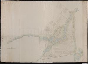
1.
Carte d'une partie de l'Amérique Septentrionale : pour servir à l'intellegence du mémoire sur les prétentions des Anglois...
2.
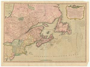
A new and correct map of the British colonies in North America : comprehending eastern Canada with the province of Quebec, New...
3.
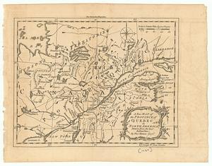
A new map of the province of Quebec in North America : drawn from the best authorities
4.
By order of His Excellency Guy Lord Dorchester... plan of part of the province of Lower Canada containing the country from the...
5.
Plan des terres de Abénaquis et Sokokis du village St-Francois situé dans le comté Buckinghamshire, district des Trois-Rivières...
6.
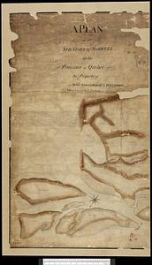
A plan of the seigniory of Sorrell in the province of Quebec the property of Messr Greenswood & Higginson, merchants in London
7.
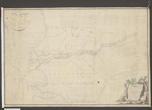
Plan of the west part of the province of Lower Canada from the R.r Sorel upwards, as far as any survey's hitherto been made
8.
Canada orientale nell' America Settentrionale
9.
Carte reduite des costes orientales de l'Amerique septentrionale : 1re. feuille contenant L'Isle Royale, L'Accadie, La Baye...
10.
A chart of the sea coast of New Foundland, New Scotland, New England, New York, New Jersey, with Virginia and Maryland
11.
Karte von dem Ostlichen-Stucke von Neu Franckreich oder Canada in America : besonders aber Acadia und Neu Schottland
12.
A new map of Nova Scotia and Cape Breton Island : with the adjacent parts of New England and Canada composed from a great...
13.
A new map of Nova Scotia, and Cape Britain : with the adjacent parts of New England and Canada, composed from a great number of...
14.
A new map of Nova Scotia, and Cape Britain : with the adjacent parts of New England and Canada, composed from a great number of...
15.
De Noordelyckste Zee Kusten van America van Groenland door de Straet Davis ende Straet Hudson tot Terra Neuf =...
16.
Partie septentrionale des possessions Angloise en Amerique : pour servire d'intelligence à la guerre présente entre les...
17.
Paskaert van de Noordelijckste kuste van America van Groenland door de Straet Davis en de Straet Hudson tot Terra Neuf
18.
1.st sheet of De Witt's state-map of New-York
19.
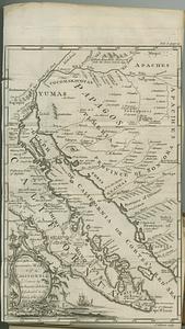
An accurate map of California drawn by the society of Jesuits, & dedicated to the king of Spain
20.
An accurate map of His Majesty's province of New Hampshire in New England, taken from actual surveys of all the inhabited part,...
‹ Prev
Next ›
1
2
3
4
5
…
19
20