Toggle navigation
LMEC Home
Exhibitions
Georeferencing
Tools for Teachers
Collections
My Favorites
Sign Up / Log In
Search
Search the map portal
Map Collection
Map Collection
Map Sets
Search
Search
Search for
Search In
All Fields
Creator
Title
Subject
Place
Search All Digital Collections
Advanced Search
489 Results
My Search
Start Over
More Like
commonwealth:wh249986p
Remove constraint More Like: commonwealth:wh249986p
Filter your Search
Place
North and Central America
486
United States
483
Suffolk (county)
475
Boston
474
Massachusetts
175
South End
61
Roxbury
49
Downtown Boston
40
more
Place
»
Topic
City planning--Massachusetts--Boston--Maps
418
Urban renewal--Massachusetts--Boston--Maps
253
Boston (Mass.)--Maps
132
Land use--Massachusetts--Boston--Maps
102
Buildings--Massachusetts--Boston--Maps
81
South End (Boston, Mass.)--Maps
56
Real property--Massachusetts--Boston--Maps
53
Roxbury (Boston, Mass.)--Maps
45
more
Topic
»
Date
Date range begin
–
Date range end
Current results range from
1835
to
2022
View distribution
Creator
Boston Redevelopment Authority
369
Downtown Waterfront Corporation
10
Victor Gruen Associates
10
Boston (Mass.). Parks and Recreation Department
9
Sasaki Associates
6
Boston (Mass.). Department of Parks
5
Charles A. Maguire and Associates
5
I.M. Pei & Associates
5
more
Creator
»
Format
Maps/Atlases
488
Drawings/Illustrations
3
Manuscripts
1
Prints
1
Georeferenced
Yes
3
No
486
Collection
Boston and New England Maps
481
Urban Maps
461
Boston Redevelopment Authority Collection
439
Norman B. Leventhal Map & Education Center Collection
103
Applied Geographics, Inc. Records
1
David Judkins Weaver Papers
1
Available to use
No known restrictions
486
Creative Commons license
2
Search Constraints
Sort by relevance
relevance
title
date (asc)
date (desc)
Number of results to display per page
20 per page
10
per page
20
per page
50
per page
100
per page
View results as:
grid view
map view
Search Results
321.
Map of the metropolitan district of Boston, Massachusetts : showing the existing public reservations and such new open spaces...
322.
The regional open space system : [Boston, Massachusetts metropolitan area]
323.
Blue Hill Avenue commercial strip
324.
Boston University, Charles River campus master plan
325.
Use of land in Boston
326.
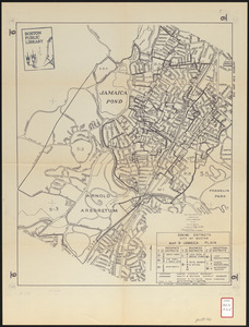
Zoning districts city of Boston map 9 Jamaica Plain
327.
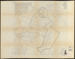
Land ownership maps for land in the Government Center urban renewal project area
328.
Map of Boston inner harbor to accompany report under chapter 93, resolves of 1907, December 1, 1907
329.
Back Bay project no. Mass R-47
330.
Back Bay project no. Mass. R-47 : police signal system, fire alarm system and M.T.A. facilities
331.
Back Bay study
332.
Back Bay study landscape plan
333.
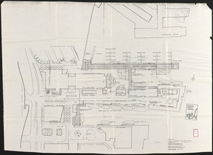
Basement plan of terminal station at Boston, Massachusetts, for the N.Y.N.H & H. and B. & A. railroads
334.
Boston Harbor : challenges and opportunities for the 1980's
335.
Boston thorofare plan existing routes and proposals
336.
Central business district urban renewal area R-82 : sub area boundaries
337.
Columbia Point feasibility survey area
338.
Contract documents for the Waterfront Park, Boston, Massachusetts : planting plan
339.
Copley Square : layout and pavement plan with tree numbers added
340.
DEM/BRA Long Wharf master plan : schematic'
‹ Prev
Next ›
1
2
…
13
14
15
16
17
18
19
20
21
…
24
25