Toggle navigation
LMEC Home
Exhibitions
Georeferencing
Tools for Teachers
Collections
My Favorites
Sign Up / Log In
Search
Search the map portal
Map Collection
Map Collection
Map Sets
Search
Search
Search for
Search In
All Fields
Creator
Title
Subject
Place
Search All Digital Collections
Advanced Search
9058 Results
My Search
Start Over
More Like
commonwealth:wd376807m
Remove constraint More Like: commonwealth:wd376807m
Filter your Search
Place
North and Central America
6,285
United States
5,168
Massachusetts
2,115
Europe
1,396
Suffolk (county)
1,103
Boston
1,071
Canada
463
Asia
438
more
Place
»
Topic
Boston (Mass.)--Maps
594
United States--History--Revolution, 1775-1783--Maps
330
United States--Maps
283
Real property--Massachusetts--Boston--Maps
175
Massachusetts--Maps
163
Landowners--Massachusetts--Boston--Maps
133
New England--Maps
103
North America--Maps--Early works to 1800
103
more
Topic
»
Date
Date range begin
–
Date range end
Current results range from
1482
to
2023
View distribution
Creator
United States. Hydrographic Office
595
O.H. Bailey & Co
148
Des Barres, Joseph F. W. (Joseph Frederick Wallet), 1722-1824
124
United States. Post Office Dept
120
Ptolemy, 2nd cent
100
Walling, Henry Francis, 1825-1888
94
Geological Survey (U.S.)
86
Jefferys, Thomas, -1771
86
more
Creator
»
Format
Maps/Atlases
8,990
Manuscripts
227
Prints
56
Books
36
Drawings/Illustrations
16
Objects/Artifacts
10
Posters
5
Georeferenced
Yes
877
No
8,181
Collection
Norman B. Leventhal Map & Education Center Collection
8,711
Boston and New England Maps
2,248
Urban Maps
2,027
Maritime Charts and Atlases
1,083
American Revolutionary War-Era Maps
978
William L. Clements Library Collection
305
Boston Redevelopment Authority Collection
87
Richard H. Brown Revolutionary War Map Collection at Mount Vernon
19
more
Collection
»
Available to use
No known restrictions
8,558
Creative Commons license
86
Search Constraints
Sort by relevance
relevance
title
date (asc)
date (desc)
Number of results to display per page
20 per page
10
per page
20
per page
50
per page
100
per page
View results as:
grid view
map view
Search Results
7721.
Sketch map of Boston and the Public Library system
7722.
Sketch map of Boston and the Public Library system
7723.
Sketch map of New South Wales showing the localities of the principal minerals 1876
7724.
Sketch map of part of Cassiar District : shewing Atlin Gold Fields B.C. ; to accompany report of Minister of Mines Victoria 1898
7725.
Sketch map of the British coast showing the relative positions of Liverpool, Beaumaris, Moelfra Bay & Point Lynas (taken from...
7726.
Sketch of Boston Harbor and Bay
7727.
Sketch of Charleston Harbor
7728.
Sketch of Charleston Harbor
7729.
Sketch of Charleston Harbor
7730.
Sketch of Guadalupe Island : west coast of Lower California
7731.
A sketch of part of the Island of New York shewing the operations of His Majesty's troops on the 16 Novr. 1776 which terminated...
7732.
Sketch of Pensacola Navy Yard and Fort Pickens from U.S. coast surveys
7733.
Sketch of sea coast of South Carolina and Georgia from Bull's Bay to Ossabaw Sound
7734.
Sketch of sea coast of South Carolina and Georgia from Bull's Bay to Ossabaw Sound
7735.
Sketch of the 11th district of western Tennessee
7736.
Sketch of the Battle of Bunker Hill
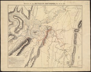
7737.
Sketch of the battles of Chattanooga, Nov. 23-26, 1863
7738.
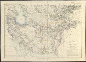
Sketch of the countries between Hindustan and the Caspian Sea
7739.
Sketch of the country illustrating the late engagement in Long Island
7740.
A sketch of the environs of Charlestown in South Carolina
‹ Prev
Next ›
1
2
…
383
384
385
386
387
388
389
390
391
…
452
453