Toggle navigation
LMEC Home
Exhibitions
Georeferencing
Tools for Teachers
Collections
My Favorites
Sign Up / Log In
Search
Search the map portal
Map Collection
Map Collection
Map Sets
Search
Search
Search for
Search In
All Fields
Creator
Title
Subject
Place
Search All Digital Collections
Advanced Search
8939 Results
My Search
Start Over
More Like
commonwealth:wd376704k
Remove constraint More Like: commonwealth:wd376704k
Filter your Search
Place
North and Central America
6,170
United States
5,072
Massachusetts
2,200
Europe
1,396
Suffolk (county)
1,215
Boston
1,188
Canada
450
Asia
438
more
Place
»
Topic
Boston (Mass.)--Maps
752
United States--Maps
282
Massachusetts--Maps
235
Real property--Massachusetts--Boston--Maps
195
City planning--Massachusetts--Boston--Maps
162
Landowners--Massachusetts--Boston--Maps
142
New England--Maps
106
North America--Maps--Early works to 1800
103
more
Topic
»
Date
Date range begin
–
Date range end
Current results range from
1482
to
2023
View distribution
Creator
United States. Hydrographic Office
595
Boston Redevelopment Authority
168
O.H. Bailey & Co
148
Des Barres, Joseph F. W. (Joseph Frederick Wallet), 1722-1824
124
United States. Post Office Dept
120
Ptolemy, 2nd cent
100
Walling, Henry Francis, 1825-1888
95
Geological Survey (U.S.)
92
more
Creator
»
Format
Maps/Atlases
8,878
Manuscripts
217
Prints
56
Books
36
Objects/Artifacts
10
Drawings/Illustrations
8
Posters
5
Ephemera
1
Georeferenced
Yes
894
No
8,045
Collection
Norman B. Leventhal Map & Education Center Collection
8,766
Boston and New England Maps
2,410
Urban Maps
2,148
Maritime Charts and Atlases
1,083
American Revolutionary War-Era Maps
657
Boston Redevelopment Authority Collection
200
David Judkins Weaver Papers
22
Mapping Boston Collection
22
more
Collection
»
Available to use
No known restrictions
8,714
Creative Commons license
73
Search Constraints
Sort by relevance
relevance
title
date (asc)
date (desc)
Number of results to display per page
20 per page
10
per page
20
per page
50
per page
100
per page
View results as:
grid view
map view
Search Results
2601.
Contour plan, Melbourne and suburbs
2602.
Conway Harbour : Port Aylesbury
2603.
Conway, N.H. : 1896
2604.
Cook's literary and historical map of London
2605.
Copia del Rio de Sn. Andres
2606.
Copies of plans of various parts of Brookline and Roxbury
2607.
Copy of an ancient plan belonging to the City (not dated probably about 1738)
2608.
Copy of an old plan belonging to the city
2609.
Copy of part of plan of inner harbor of Boston, showing commissioners' lines
2610.
Corey Hill Terraces, Brookline
2611.
Cornell University campus
2612.
Cornubia, Davonia, Somersetus, Dorcestria, Wiltonia, Glocestria, Monumetha, Glamorgan, Caermarden, Pembroke, Cardigan, Radnor,...
2613.
A correct chart of the North Sea, with the adjacent coasts of Britain, Holland, Germany, Denmark, Norway, the islands of Orkney...
2614.
A correct map of Connecticut from actual survey
2615.
A correct map of Europe divided into its empire, kingdoms &c.
2616.
A correct map of Pensacola Bay showing topography of the coast, Fort Pickens, U.S. Navy Yard, and all other fortifications from...
2617.
A correct map of the African islands of Bourbon, and Mauritius or the Isle of France
2618.
A correct map of the coast of New England
2619.
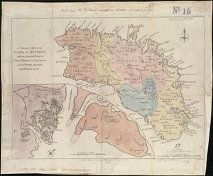
A Correct map of the island of Minorca, with an accurate plan of Fort St. Philip & its environs, and the French approaches and...
2620.
A correct map of the seat of war in Mexico : being a copy of Genl. Arista's map, taken at Resaca de la Palma, with additions...
‹ Prev
Next ›
1
2
…
127
128
129
130
131
132
133
134
135
…
446
447