Toggle navigation
LMEC Home
Exhibitions
Georeferencing
Tools for Teachers
Collections
My Favorites
Sign Up / Log In
Search
Search the map portal
Map Collection
Map Collection
Map Sets
Search
Search
Search for
Search In
All Fields
Creator
Title
Subject
Place
Search All Digital Collections
Advanced Search
9135 Results
My Search
Start Over
More Like
commonwealth:wd376646w
Remove constraint More Like: commonwealth:wd376646w
Filter your Search
Place
North and Central America
6,366
United States
5,282
Massachusetts
2,199
Suffolk (county)
1,470
Boston
1,443
Europe
1,396
Canada
449
Asia
438
more
Place
»
Topic
Boston (Mass.)--Maps
752
City planning--Massachusetts--Boston--Maps
418
United States--Maps
282
Urban renewal--Massachusetts--Boston--Maps
253
Real property--Massachusetts--Boston--Maps
225
Massachusetts--Maps
166
Landowners--Massachusetts--Boston--Maps
144
New England--Maps
104
more
Topic
»
Date
Date range begin
–
Date range end
Current results range from
1482
to
2023
View distribution
Creator
United States. Hydrographic Office
595
Boston Redevelopment Authority
399
O.H. Bailey & Co
148
Des Barres, Joseph F. W. (Joseph Frederick Wallet), 1722-1824
124
United States. Post Office Dept
120
Ptolemy, 2nd cent
100
Walling, Henry Francis, 1825-1888
94
Geological Survey (U.S.)
87
more
Creator
»
Format
Maps/Atlases
9,075
Manuscripts
215
Prints
56
Books
36
Objects/Artifacts
10
Drawings/Illustrations
8
Posters
5
Georeferenced
Yes
885
No
8,250
Collection
Norman B. Leventhal Map & Education Center Collection
8,728
Boston and New England Maps
2,622
Urban Maps
2,404
Maritime Charts and Atlases
1,083
American Revolutionary War-Era Maps
638
Boston Redevelopment Authority Collection
454
Mapping Boston Collection
20
Massachusetts Real Estate Atlases
18
more
Collection
»
Available to use
No known restrictions
8,932
Creative Commons license
70
Search Constraints
Sort by relevance
relevance
title
date (asc)
date (desc)
Number of results to display per page
20 per page
10
per page
20
per page
50
per page
100
per page
View results as:
grid view
map view
Search Results
201.
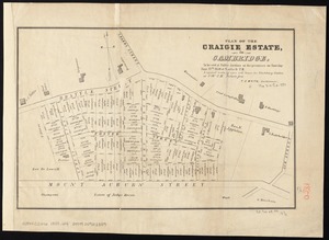
Plan of the Craigie Estate in Cambridge : to be sold at public auction on the premises on Thursday June 27th, 1850 at 4 o'clock...
202.
660 Wakulah St., Roxbury
203.
Allston-Brighton open space plan site inventory
204.
Appleton St. Woonerf
205.
Berkeley Street community garden
206.
Boston Common - Barry Memorial
207.
Boston Common Brewer Fountain - exist. conditions, demolition plan and site plan for comfort station area
208.
Boylston Street : Fenway to Massachusetts Avenue
209.
Boylston Street improvements
210.
Brighton and Allston urban design strategy
211.
Building deficiencies map : Government Center project no. Mass. R-35
212.
Capital Park : Hyde Park ... Boston
213.
Charlestown urban renewal area project no. Mass. R-55 Boston - Suffolk County - Massachusetts delivery parcel plan : parcel...
214.
Charlestown urban renewal project Boston (Suffolk County) Massachusetts Mass. R-55 : topographic map
215.
Charlestown Veterans Memorial, Charlestown, Massachusetts
216.
Circulation plan of parking lot at the corner of VFW Parkway and Spring Street, West Roxbury
217.
Columbia Point development study
218.
Columbia Point updated base maps
219.
Flirtation walk existing conditions plan Charlestown Navy Yard
220.
Flirtation walk schematic planting plan Charlestown Navy Yard
‹ Prev
Next ›
1
2
…
7
8
9
10
11
12
13
14
15
…
456
457