Toggle navigation
LMEC Home
Exhibitions
Georeferencing
Tools for Teachers
Collections
My Favorites
Sign Up / Log In
Search
Search the map portal
Map Collection
Map Collection
Map Sets
Search
Search
Search for
Search In
All Fields
Creator
Title
Subject
Place
Search All Digital Collections
Advanced Search
8627 Results
My Search
Start Over
More Like
commonwealth:w9505r51x
Remove constraint More Like: commonwealth:w9505r51x
Filter your Search
Place
North and Central America
5,865
United States
4,784
Massachusetts
2,052
Europe
1,359
Suffolk (county)
1,034
Boston
1,007
Canada
453
Asia
422
more
Place
»
Topic
Boston (Mass.)--Maps
577
United States--Maps
273
North America--Maps--Early works to 1800
180
Real property--Massachusetts--Boston--Maps
174
Massachusetts--Maps
160
Landowners--Massachusetts--Boston--Maps
132
New England--Maps
99
Europe--Maps
78
more
Topic
»
Date
Date range begin
–
Date range end
Current results range from
1482
to
2023
View distribution
Creator
United States. Hydrographic Office
594
O.H. Bailey & Co
148
Des Barres, Joseph F. W. (Joseph Frederick Wallet), 1722-1824
123
United States. Post Office Dept
120
Ptolemy, 2nd cent
100
Walling, Henry Francis, 1825-1888
94
Jefferys, Thomas, -1771
90
Geological Survey (U.S.)
86
more
Creator
»
Format
Maps/Atlases
8,568
Manuscripts
217
Prints
56
Books
36
Objects/Artifacts
10
Drawings/Illustrations
8
Posters
4
Georeferenced
Yes
872
No
7,755
Collection
Norman B. Leventhal Map & Education Center Collection
8,558
Boston and New England Maps
2,205
Urban Maps
1,936
Maritime Charts and Atlases
1,081
American Revolutionary War-Era Maps
679
Boston Redevelopment Authority Collection
87
New York Public Library Collection
32
Richard H. Brown Revolutionary War Map Collection at Mount Vernon
18
more
Collection
»
Available to use
No known restrictions
8,411
Creative Commons license
110
Search Constraints
Sort by date (asc)
relevance
title
date (asc)
date (desc)
Number of results to display per page
20 per page
10
per page
20
per page
50
per page
100
per page
View results as:
grid view
map view
Search Results
21.
Secunda Affrice tabula continet Affricam & insulae que circa ipsam sunt
22.
Secunda Asie tabula continet Sarmatia ipsius
23.
Secunda Europe tabula
24.
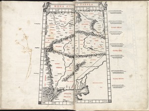
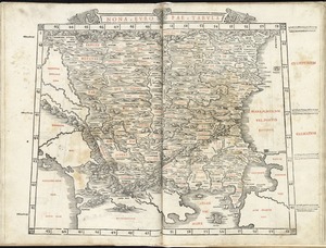
Septima Asia tabula continet Margianam, Bactrianam, Sogdianos, Sacas & Scythiam intra Imaū mōtē
25.
Septima Europa tabula continet Sardininiam & Sicilia insulas
26.
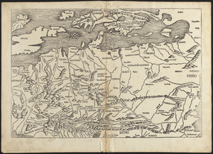
Sexta Asie tabula continet Arabiam, Felice atq[ue] Carmania cu adiacentibus insulis
27.
Sexta Europa tabula continet Italiam
28.
Tercia Europe tabula continet Gallia
29.
Tertia Affrice tabula continet Cyrenainaycam & Egyptum cum adiacentibus insulis
30.
Tertia Asie tabula continet Colchide, Iberia, Albania :& maiorem Armenia
31.
Undecima Asie tabula continet India ext. Gange & Sinas
32.
The world
33.
Europe
34.
Leaves from Liber chronicarum, with views of de Sarmatia regione Europe, Cracovia, Lubeca and Nissa
35.
Decima Asiae tabula
36.
Decima et ultima Europae tabula
37.
Duodecima Asiae tabula
38.
Nona Asiae tabula
39.
Nona Europae tabula
40.
Octava Asiae tabula
‹ Prev
Next ›
1
2
3
4
5
6
…
431
432


![Sexta Asie tabula continet Arabiam, Felice atq[ue] Carmania cu adiacentibus insulis](https://bpldcassets.blob.core.windows.net/derivatives/images/commonwealth:7h14b122w/image_thumbnail_300.jpg)