The world
Item Information
- Title:
- The world
- Description:
-
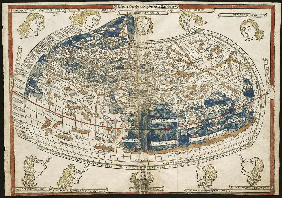
The classical Greek and Roman world view is known to us through the writings of Claudius Ptolemy, a 2nd century A.D. astronomer, mathematician, and geographer who lived in Alexandria, Egypt. Although his original manuscript no longer exists, various copies survived through the Middle Ages. With the advent of the printing press in the late-15th century, it was one the first geographical texts printed. The first printed editions of "Geographia" included a world map and 26 regional maps. These maps depicted the extent of the world as known to the ancient Greeks and Romans, which focused on the lands bordering the Mediterranean -- Europe, northern Africa, and western and southern Asia. Despite the disclosure of New World discoveries, such maps still had a strong influence on the Europeans' geographical concept of the world. Unfortunately for the early explorers, this world image underestimated the Earth's circumference and overestimated the breadth of the Eurasian land mass. While the first printed edition of "Geographia" that included maps was published in Bolgona in 1477, the Ulm edition was the first printed north of the Alps and the first to include wood cut printed maps. New and updated versions of "Geographia" were printed until the mid-19th century.
- Creator:
- Ptolemy, active 2nd century
- Printer:
- Hol, Lienhart
- Engraver:
- Schnitzer, Johannes
- Date:
-
[1482]
- Format:
-
Maps/Atlases
- Location:
-
Boston Public Library
Norman B. Leventhal Map & Education Center - Collection (local):
-
Norman B. Leventhal Map & Education Center Collection
- Subjects:
-
World maps
- Places:
-
World
- Extent:
- 1 map : hand col. ; 40 x 56 cm.
- Terms of Use:
-
No known copyright restrictions.
No known restrictions on use.
- Publisher:
-
Ulm :
Lienhart Hol
- Scale:
-
Scale [ca. 1:35,000,000]
- Language:
-
Latin
- Notes:
-
Prime meridian: Ferro.
Title supplied by cataloger.
At head of map: Insculptum est per Iohane Schnitzer de Armszheim.
Engraved on wood with place names in moveable type.
Includes names of places and natural features.
In margin: notes on latitude.
Appears in the author's Geographia. Ulm : Lienhart Hol, 16 July 1482.
Includes ill. of windheads.
Cataloging, conservation, and digitization made possible in part by The National Endowment for the Humanities: Exploring the human endeavor.
Text in Latin.
Cataloging, conservation, and digitization made possible in part by The National Endowment for the Humanities: Exploring the human endeavor.
Atlas scanned by Internet Archive http://www.archive.org/details/cosmographia00ptol
- Notes (date):
-
This date is inferred.
- Notes (exhibitions):
-
Exhibited: "Journeys of the Imagination" organized by the Norman B. Leventhal Map Center at the Boston Public Library, 2006.
Exhibited: "Regions and Seasons: Mapping Climate through History" organized by the Norman B. Leventhal Map Center at the Boston Public Library, 2017.
- Identifier:
-
05_01_000200
- Call #:
-
G1005 .P7 1482
- Barcode:
-
30000003117916


