Toggle navigation
LMEC Home
Exhibitions
Georeferencing
Tools for Teachers
Collections
My Favorites
Sign Up / Log In
Search
Search the map portal
Map Collection
Map Collection
Map Sets
Search
Search
Search for
Search In
All Fields
Creator
Title
Subject
Place
Search All Digital Collections
Advanced Search
8803 Results
My Search
Start Over
More Like
commonwealth:tt44pw386
Remove constraint More Like: commonwealth:tt44pw386
Filter your Search
Place
North and Central America
6,098
United States
5,020
Massachusetts
2,106
Europe
1,359
Suffolk (county)
1,283
Boston
1,256
Canada
448
Asia
422
more
Place
»
Topic
Boston (Mass.)--Maps
740
United States--Maps
273
Real property--Massachusetts--Boston--Maps
251
City planning--Massachusetts--Boston--Maps
216
Landowners--Massachusetts--Boston--Maps
169
Massachusetts--Maps
163
Urban renewal--Massachusetts--Boston--Maps
124
North America--Maps--Early works to 1800
103
more
Topic
»
Date
Date range begin
–
Date range end
Current results range from
1482
to
2023
View distribution
Creator
United States. Hydrographic Office
594
Boston Redevelopment Authority
221
O.H. Bailey & Co
148
Des Barres, Joseph F. W. (Joseph Frederick Wallet), 1722-1824
124
United States. Post Office Dept
120
Ptolemy, 2nd cent
100
Walling, Henry Francis, 1825-1888
94
Geological Survey (U.S.)
87
more
Creator
»
Format
Maps/Atlases
8,744
Manuscripts
215
Prints
56
Books
36
Objects/Artifacts
10
Drawings/Illustrations
8
Posters
4
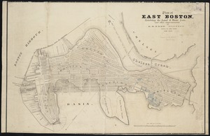
Georeferenced
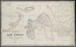
Yes
885
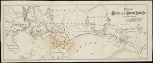
No
7,918
Collection
Norman B. Leventhal Map & Education Center Collection
8,575
Boston and New England Maps
2,389
Urban Maps
2,118
Maritime Charts and Atlases
1,081
American Revolutionary War-Era Maps
638
Boston Redevelopment Authority Collection
255
Massachusetts Real Estate Atlases
38
Mapping Boston Collection
20
more
Collection
»
Available to use
No known restrictions
8,581
Creative Commons license
69
Search Constraints
Sort by relevance
relevance
title
date (asc)
date (desc)
Number of results to display per page
20 per page
10
per page
20
per page
50
per page
100
per page
View results as:
grid view
map view
Search Results
101.
Plan of the South Cove
102.
A rough and inaccurate sketch of the streets of Boston as they are supposed to have been first laid out & the owners of the...
103.
Plan for the occupation of flats owned by the Commonwealth in Boston Harbor
104.
Atlas of the city of Boston : South Boston
105.
Atlas of the city of Boston : South Boston
106.
Atlas of the county of Suffolk, Massachusetts, vol. 3 : including South Boston and Dorchester
107.
Atlas of the city of Boston : East Boston
108.
Atlas of the county of Suffolk, Massachusetts, vol. 4 : including East Boston, city of Chelsea, Revere and Winthrop
109.
General plan for Columbus Park, Strandway, South Boston
110.
Plan of South Boston
111.
Plan of the proposed docks at South Boston
112.
South Boston
113.
A plan of a survey of Noddles Island
114.
Plan of Boston Land Co's land in Boston & Revere
115.
Plan of East Boston
116.
Plan of East Boston : exhibiting the land & water lots and other improvements
117.
Plan of East Boston showing the land and water lots sold and unsold : also all buildings and other improvements
118.
Plan of estate of the Boston Land Co. and surroundings
119.
Plan of Orient Heights, Boston, Mass
120.
Plan of property of the National Dock & Warehouse Co. East Boston
‹ Prev
Next ›
1
2
3
4
5
6
7
8
9
10
…
440
441