Toggle navigation
LMEC Home
Exhibitions
Georeferencing
Tools for Teachers
Collections
My Favorites
Sign Up / Log In
Search
Search the map portal
Map Collection
Map Collection
Map Sets
Search
Search
Search for
Search In
All Fields
Creator
Title
Subject
Place
Search All Digital Collections
Advanced Search
8786 Results
My Search
Start Over
More Like
commonwealth:tt44pw229
Remove constraint More Like: commonwealth:tt44pw229
Filter your Search
Place
North and Central America
6,017
United States
4,934
Massachusetts
2,089
Europe
1,396
Suffolk (county)
1,136
Boston
1,109
Canada
449
Asia
438
more
Place
»
Topic
Boston (Mass.)--Maps
607
United States--Maps
282
Real property--Massachusetts--Boston--Maps
253
Landowners--Massachusetts--Boston--Maps
169
Massachusetts--Maps
163
City planning--Massachusetts--Boston--Maps
118
North America--Maps--Early works to 1800
103
New England--Maps
102
more
Topic
»
Date
Date range begin
–
Date range end
Current results range from
1482
to
2023
View distribution
Creator
United States. Hydrographic Office
595
O.H. Bailey & Co
148
Des Barres, Joseph F. W. (Joseph Frederick Wallet), 1722-1824
123
United States. Post Office Dept
120
Boston Redevelopment Authority
119
Ptolemy, 2nd cent
100
Walling, Henry Francis, 1825-1888
94
Geological Survey (U.S.)
87
more
Creator
»
Format
Maps/Atlases
8,726
Manuscripts
215
Prints
56
Books
36
Objects/Artifacts
10
Drawings/Illustrations
8
Posters
5
Georeferenced
Yes
870
No
7,916
Collection
Norman B. Leventhal Map & Education Center Collection
8,695
Boston and New England Maps
2,288
Urban Maps
2,078
Maritime Charts and Atlases
1,083
American Revolutionary War-Era Maps
616
Boston Redevelopment Authority Collection
142
Massachusetts Real Estate Atlases
36
Applied Geographics, Inc. Records
1
Available to use
No known restrictions
8,608
Creative Commons license
47
Search Constraints
Sort by relevance
relevance
title
date (asc)
date (desc)
Number of results to display per page
20 per page
10
per page
20
per page
50
per page
100
per page
View results as:
grid view
map view
Search Results
2501.
Fishing grounds on the Atlantic coast of North America
2502.
Fishing grounds out of Boston : NLSECO marine diesel oil engines ; built by New London Ship & Engine Co., Groton, Conn
2503.
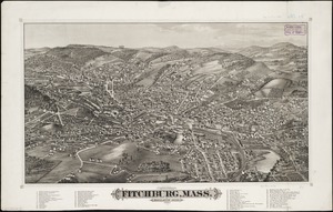
Fitchburg, Mass : population 14,000, 1882
2504.
Fitton Bay (Peel Id.) from the survey of Captain F.W. Beechey, R.N. 1827 ; Coffin Group by officers of the U.S. Ship Plymouth,...
2505.
Fitz globe
2506.
Flamm's new map of Baltimore and vicinity
2507.
Flandria
2508.
Flathead National Forest, Montana
2509.
Flemington : New Jersey
2510.
Flirtation walk existing conditions plan Charlestown Navy Yard
2511.
Flirtation walk schematic planting plan Charlestown Navy Yard
2512.
Flood progression map : 9" SLR
2513.
Flood progression map : 21" SLR
2514.
Flood progression map : 36" SLR
2515.
Florence
2516.
La Florida
2517.
Florida called by ye French Louisiana &c
2518.
Florida from the latest authorities
2519.
Florida gebiet
2520.
La Floride, suivant les nouvelles observations de Messrs. de l'Academie des Sciences, etc : augmentées de Nouveau
‹ Prev
Next ›
1
2
…
122
123
124
125
126
127
128
129
130
…
439
440