Toggle navigation
LMEC Home
Exhibitions
Georeferencing
Tools for Teachers
Collections
My Favorites
Sign Up / Log In
Search
Search the map portal
Map Collection
Map Collection
Map Sets
Search
Search
Search for
Search In
All Fields
Creator
Title
Subject
Place
Search All Digital Collections
Advanced Search
8792 Results
My Search
Start Over
More Like
commonwealth:tt44pv58g
Remove constraint More Like: commonwealth:tt44pv58g
Filter your Search
Place
North and Central America
6,036
United States
4,956
Massachusetts
2,076
Europe
1,388
Suffolk (county)
1,193
Boston
1,166
Canada
449
Asia
436
more
Place
»
Topic
Boston (Mass.)--Maps
602
United States--Maps
279
Real property--Massachusetts--Boston--Maps
253
City planning--Massachusetts--Boston--Maps
172
Landowners--Massachusetts--Boston--Maps
169
Massachusetts--Maps
161
North America--Maps--Early works to 1800
103
New England--Maps
101
more
Topic
»
Date
Date range begin
–
Date range end
Current results range from
1482
to
2023
View distribution
Creator
United States. Hydrographic Office
595
Boston Redevelopment Authority
174
O.H. Bailey & Co
148
Des Barres, Joseph F. W. (Joseph Frederick Wallet), 1722-1824
123
United States. Post Office Dept
120
Ptolemy, 2nd cent
100
Walling, Henry Francis, 1825-1888
94
Geological Survey (U.S.)
86
more
Creator
»
Format
Maps/Atlases
8,733
Manuscripts
215
Prints
56
Books
36
Objects/Artifacts
10
Drawings/Illustrations
8
Posters
4
Georeferenced
Yes
871
No
7,921
Collection
Norman B. Leventhal Map & Education Center Collection
8,641
Boston and New England Maps
2,338
Urban Maps
2,102
Maritime Charts and Atlases
1,083
American Revolutionary War-Era Maps
616
Boston Redevelopment Authority Collection
203
Massachusetts Real Estate Atlases
35
Applied Geographics, Inc. Records
2
more
Collection
»
Available to use
No known restrictions
8,614
Creative Commons license
48
Search Constraints
Sort by relevance
relevance
title
date (asc)
date (desc)
Number of results to display per page
20 per page
10
per page
20
per page
50
per page
100
per page
View results as:
grid view
map view
Search Results
3621.
A map of Amherst with a view of the college and Mount Pleasant Institution
3622.
Map of an exploring expedition to the Rocky Mountains in the year 1842 and to Oregon & north California in the years 1843-44
3623.
Map of Anacostia River in the District of Columbia : from survey authorized and directed by Joint Resolution of Cnogress, Apr....
3624.
Map of Andersonville, Sumter Co., Georgia
3625.
Map of Arizona Territory
3626.
Map of Arkansas : from government and other authentic sources
3627.
Map of Armstrong Co. Pennsylvania
3628.
Map of Aroostook County, Maine
3629.
Map of Atlantic & Pacific Rail Road
3630.
Map of Augusta County, Virginia
3631.
Map of Australia, compiled from the nautical surveys, made by order of The Admiralty and other authentic documents
3632.
Map of Baldwinville and Winchendon rail road routes
3633.
Map of Bar Harbor, Maine
3634.
Map of Bath, Maine
3635.
Map of battles on Bull Run, near Manassas, on the line of Fairfax & Prince William Counties, in Virginia, fought between the...
3636.
Map of Bennington County, Vermont
3637.
[Map of Berkshire County]
3638.
A map of Berkshire County Mass
3639.
Map of Beverly
3640.
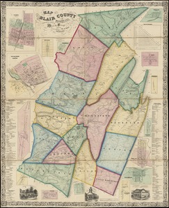
Map of Blair County, Pennsylvania : from special surveys
‹ Prev
Next ›
1
2
…
178
179
180
181
182
183
184
185
186
…
439
440


![[Map of Berkshire County]](https://bpldcassets.blob.core.windows.net/derivatives/images/commonwealth:wd376641h/image_thumbnail_300.jpg)