Toggle navigation
LMEC Home
Exhibitions
Georeferencing
Tools for Teachers
Collections
My Favorites
Sign Up / Log In
Search
Search the map portal
Map Collection
Map Collection
Map Sets
Search
Search
Search for
Search In
All Fields
Creator
Title
Subject
Place
Search All Digital Collections
Advanced Search
8736 Results
My Search
Start Over
More Like
commonwealth:st74cw92q
Remove constraint More Like: commonwealth:st74cw92q
Filter your Search
Place
North and Central America
5,967
United States
4,865
Massachusetts
2,078
Europe
1,396
Suffolk (county)
1,045
Boston
1,018
Canada
450
Asia
438
more
Place
»
Topic
Boston (Mass.)--Maps
586
United States--Maps
282
Real property--Massachusetts--Boston--Maps
175
Massachusetts--Maps
162
Landowners--Massachusetts--Boston--Maps
133
North America--Maps--Early works to 1800
105
New England--Maps
102
Europe--Maps
79
more
Topic
»
Date
Date range begin
–
Date range end
Current results range from
1482
to
2023
View distribution
Creator
United States. Hydrographic Office
595
O.H. Bailey & Co
148
Des Barres, Joseph F. W. (Joseph Frederick Wallet), 1722-1824
126
United States. Post Office Dept
120
Ptolemy, 2nd cent
100
Walling, Henry Francis, 1825-1888
94
Jefferys, Thomas, -1771
90
Geological Survey (U.S.)
86
more
Creator
»
Format
Maps/Atlases
8,676
Manuscripts
220
Prints
56
Books
36
Objects/Artifacts
10
Drawings/Illustrations
8
Posters
5
Georeferenced
Yes
871
No
7,865
Collection
Norman B. Leventhal Map & Education Center Collection
8,694
Boston and New England Maps
2,232
Urban Maps
2,023
Maritime Charts and Atlases
1,088
American Revolutionary War-Era Maps
656
Boston Redevelopment Authority Collection
87
MacLean Collection Map Library
17
Richard H. Brown Revolutionary War Map Collection at Mount Vernon
9
more
Collection
»
Available to use
No known restrictions
8,553
Creative Commons license
70
Search Constraints
Sort by relevance
relevance
title
date (asc)
date (desc)
Number of results to display per page
20 per page
10
per page
20
per page
50
per page
100
per page
View results as:
grid view
map view
Search Results
1.
Virginiae partis australis et Floridae partis orientalis, interjacentium[que] regionum nova descriptio
2.
A new map of Carolina
3.
Virginiae item et Floridae Americae provinciarum, nova descriptio
4.
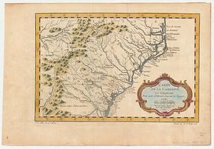
Carte des deux Carolines et de la Géorgie
5.
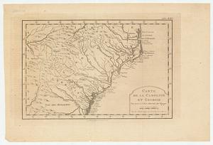
Carte de la Caroline et Georgie : pour servir à l'histoire générale des voyages
6.
Carte de la Caroline et Georgie : pour servir à l'histoire générale des voyages
7.
A map of the seat of war in the southern part of Virginia, North Carolina, and the northern part of South Carolina
8.
Partie meridionale des possessions angloise en Amerique
9.
A chart of South Carolina and Georgia
10.
A chart of South Carolina and Georgia
11.
A chart of South Carolina and Georgia
12.
A chart of South Carolina and Georgia
13.
A map of South Carolina and a part of Georgia : containing the whole sea-coast; all the islands, inlets, rivers, creeks,...
14.
An accurate map of North and South Carolina with their Indian frontiers, shewing in a distinct manner all the mountains,...
15.
Carolina
16.
Chart of the coast of America from Cape Hateras to Cape Roman
17.
Chart of the coast of America from Cape Hateras to Cape Roman
18.
Chart of the coast of America from Cape Hateras to Cape Roman
19.
Chart of the coast of America from Cape Hateras to Cape Roman
20.
A New description of Carolina
‹ Prev
Next ›
1
2
3
4
5
…
436
437
![Virginiae partis australis et Floridae partis orientalis, interjacentium[que] regionum nova descriptio](https://bpldcassets.blob.core.windows.net/derivatives/images/commonwealth:6t053p120/image_thumbnail_300.jpg)