Toggle navigation
LMEC Home
Exhibitions
Georeferencing
Tools for Teachers
Collections
My Favorites
Sign Up / Log In
Search
Search the map portal
Map Collection
Map Collection
Map Sets
Search
Search
Search for
Search In
All Fields
Creator
Title
Subject
Place
Search All Digital Collections
Advanced Search
513 Results
My Search
Start Over
More Like
commonwealth:q524nf16p
Remove constraint More Like: commonwealth:q524nf16p
Filter your Search
Place
North and Central America
452
United States
326
New York
41
District of Columbia
30
Washington
29
Florida
19
Canada
17
Alabama
15
more
Place
»
Topic
Manuscript maps--Early works to 1800
92
Washington (D.C.)--Maps
31
Manuscript maps
21
Gulf Coast (U.S.)--Maps, Manuscript--Early works to 1800
12
Fortification--New York (State)--New York--Maps--Early works to 1800
11
New York (N.Y.)--Buildings, structures, etc--Maps, Manuscript--Early works to 1800
9
New York (N.Y.)--Maps, Manuscript--Early works to 1800
8
Saratoga Campaign, N.Y., 1777--Maps, Manuscript--Early works to 1800
8
more
Topic
»
Date
Date range begin
–
Date range end
Current results range from
1700
to
1926
View distribution
Creator
Hills, John, (Surveyor)
18
Montrésor, John, 1736-1799
16
Bingham, William, 1752-1804
12
Adlum, John, 1759-1836
10
Washington, George, 1732-1799
9
Faden, William, 1749-1836
7
Morgan, Benjamin, (Draftsman)
7
Wangenheim, Friedrich Adam Julius von
7
more
Creator
»
Format
Maps/Atlases
511
Manuscripts
475
Objects/Artifacts
2
Georeferenced
Yes
13
No
500
Collection
American Revolutionary War-Era Maps
484
Library of Congress Collection
480
Maritime Charts and Atlases
30
Norman B. Leventhal Map & Education Center Collection
29
Urban Maps
19
William L. Clements Library Collection
2
MacLean Collection Map Library
1
New York Public Library Collection
1
Available to use
Creative Commons license
481
No known restrictions
29
Search Constraints
Sort by relevance
relevance
title
date (asc)
date (desc)
Number of results to display per page
20 per page
10
per page
20
per page
50
per page
100
per page
View results as:
grid view
map view
Search Results
101.
Descripción de la costa de la Luciana y entrada en el Río de Micisipi con sus sondas y bajos, nuebamte. correjido y enmendado...
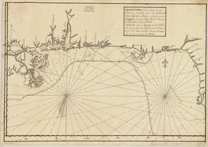
102.
Descripcion de la costa de Tierra Firme desde el Cavo de la Agusa hasta la Barra de Palmas diga de la Trinidad : Con todas las...
103.
Descripcion de la costa de Tierra Firme desde el Rio de la Empalizada hasta Cavo de Clara : Por las latitudes y longitudes de...
104.
Descripcion de las costas, islas placeres, i bajos delas, Indias Occidentales
105.
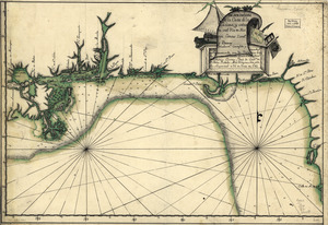
Descripción ychonográfica de la ciudad, puerto y bahía de Santiago de Cuba situado en 20⁰6ʹ de latitud norte y en longd. de...
106.
Descripsión de la costa de la Luciana y entrada en el Río de Micisipi con sus zondas y bajos, nuebamente corregidos y...
107.
Descripsión de la costa de la Luciana y entrada en el Río de Micisipi con sus zonds. y baxos, nuebamte. correjido y enmendo...
108.
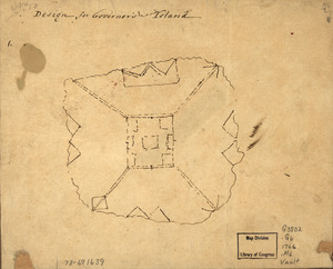
Design for Governor's Island
109.
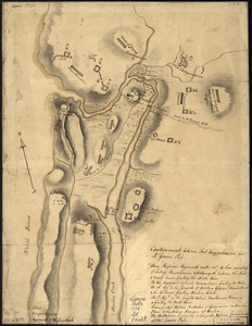
Disposition of British troops, with fortifications north of Fort Knipehausen, i.e. Fort Washington to Fort Independence
110.
Done by order of His excellency Montagu Wilmot, Esq. Governor and Commander in Chief of Nova Scotia, &c., &., &
111.
Dotted line map of Washington, D.C., 1791, before Aug. 19th
112.
Draft of roads in New Jersey
113.
Draft of the lands disputed by Philipse Patent against Beekmans & Rambaults
114.
A draught of Delaware Bay
115.
A draught of Lake George, and part of Hudson's River taken September 1756
116.
Dto de Baton Rouge
117.
E. Sugar Creek, Bradford Co
118.
Eight survey tracts along the Kanawha River, W.Va : showing land granted to George Washington and others
119.
The encampment & position of the army under His Excy. Lt. Gl: Burgoyne : at Swords's and Freeman's Farms on Hudsons River near...
120.
The encampment & position of the army under His Excy. Lt. Gl: Burgoyne : at Swords's and Freeman's Farms on Hudsons River near...
‹ Prev
Next ›
1
2
3
4
5
6
7
8
9
10
…
25
26