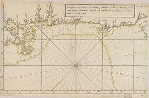
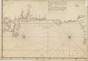
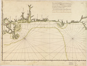
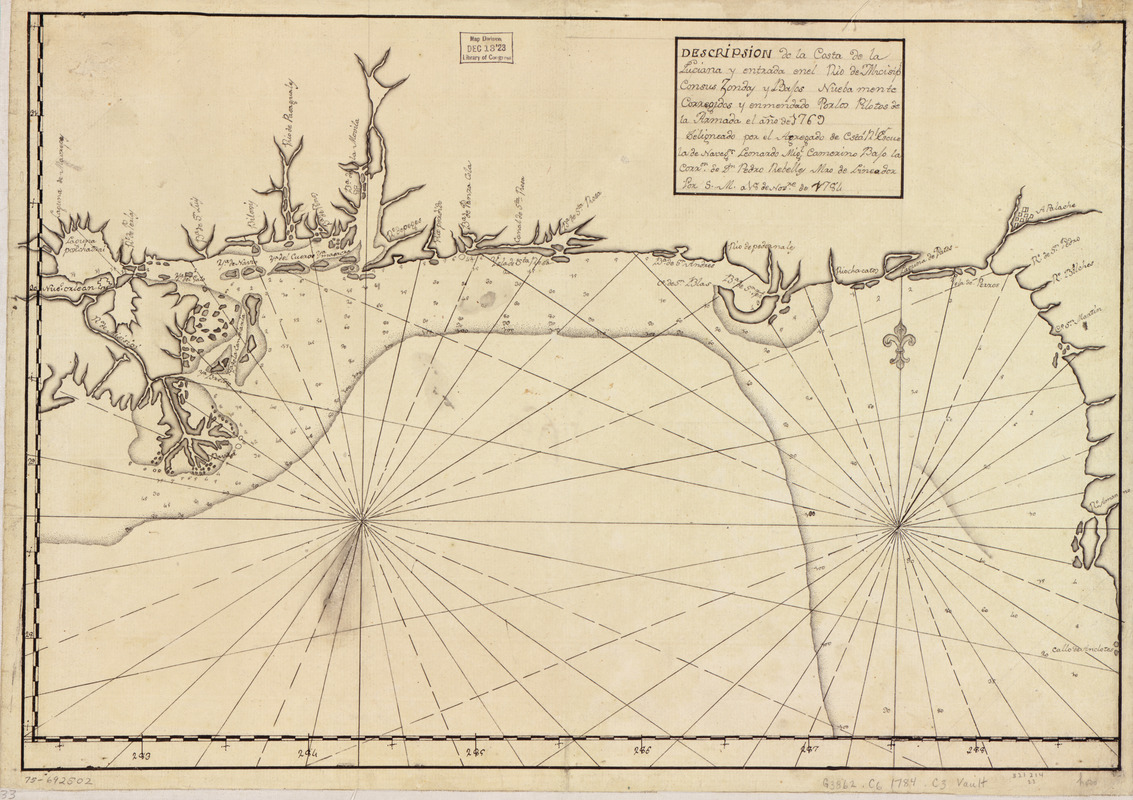
Descripsión de la costa de la Luciana y entrada en el Río de Micisipi con sus zondas y bajos, nuebamente corregidos y enmendado por los pilotos de la Armada, el año de 1769
This map is also available in American Revolutionary Geographies Online (ARGO), a collections portal especially built for material relating to the American Revolutionary War Era. Visit ARGO to learn more about this item and explore the historical geography of North America in the late eighteenth century.
Item Information
- Title:
- Descripsión de la costa de la Luciana y entrada en el Río de Micisipi con sus zondas y bajos, nuebamente corregidos y enmendado por los pilotos de la Armada, el año de 1769
- Creator:
- Camerino, Leonardo Miguel
- Name on Item:
-
Deligneado por el agregado de esta Rl. Escuela de Navegón. Leonardo Migl. Camerino bajo la corrón. de Dn. Pedro Rebelles, mro. delineador por S. M. a 18 de novre. de 1784
- Date:
-
[1784]
- Format:
-
Maps/Atlases
Manuscripts
- Location:
- Library of Congress Geography and Map Division
- Collection (local):
-
Library of Congress Collection
- Subjects:
-
Gulf Coast (U.S.)--Maps, Manuscript--Early works to 1800
- Places:
-
Florida
Alabama
Louisiana
Mississippi
- Extent:
- 1 manuscript map 36 x 54 cm.
- Terms of Use:
-
No known copyright restrictions.
This work is licensed for use under a Creative Commons Attribution Non-Commercial Share Alike License (CC BY-NC-SA).

- Scale:
-
Scale ca. 1:1,330,000
- Language:
-
Spanish
- Catalog Record:
-
https://lccn.loc.gov/75692502
- Notes:
-
Manuscript, pen-and-ink.
Watermarks: J. Kool; and, Strasburg fleur-de-lis.
Order number annotated in pencil in lower right margin: 321214/23.
Printed label describing the map mounted on verso.
Depths shown by soundings.
Shows Gulf Coast from Mississippi River Delta to Anclote Keys, Florida.
Mounted on cloth backing.
- Notes (date):
-
This date is inferred.
- Notes (citation):
-
LC Luso-Hispanic World, 834
LC Maps of North America, 1750-1789, 1613
- Identifier:
-
lh000834