Toggle navigation
LMEC Home
Exhibitions
Georeferencing
Tools for Teachers
Collections
My Favorites
Sign Up / Log In
Search
Search the map portal
Map Collection
Map Collection
Map Sets
Search
Search
Search for
Search In
All Fields
Creator
Title
Subject
Place
Search All Digital Collections
Advanced Search
532 Results
My Search
Start Over
More Like
commonwealth:q524nd00k
Remove constraint More Like: commonwealth:q524nd00k
Filter your Search
Place
North and Central America
467
United States
328
New York
41
Canada
26
Florida
20
Mississippi
18
Alabama
17
Chatham (county)
16
more
Place
»
Topic
Manuscript maps--Early works to 1800
138
Manuscript maps
21
Gulf Coast (U.S.)--Maps, Manuscript--Early works to 1800
12
Fortification--New York (State)--New York--Maps--Early works to 1800
11
New York (N.Y.)--Buildings, structures, etc--Maps, Manuscript--Early works to 1800
9
New York (N.Y.)--Maps, Manuscript--Early works to 1800
8
Saratoga Campaign, N.Y., 1777--Maps, Manuscript--Early works to 1800
8
Coasts--Florida--Maps--Early works to 1800
7
more
Topic
»
Date
Date range begin
–
Date range end
Current results range from
1700
to
1899
View distribution
Creator
Hills, John, (Surveyor)
18
Montrésor, John, 1736-1799
16
Dumont de Montigny
14
Bingham, William, 1752-1804
12
Adlum, John, 1759-1836
10
Washington, George, 1732-1799
9
Faden, William, 1749-1836
7
Morgan, Benjamin, (Draftsman)
7
more
Creator
»
Format
Maps/Atlases
530
Manuscripts
526
Objects/Artifacts
2
Georeferenced
Yes
6
No
526
Collection
American Revolutionary War-Era Maps
527
Library of Congress Collection
485
Newberry Library Collection
39
Maritime Charts and Atlases
32
Urban Maps
17
British Library Collection
5
Boston and New England Maps
4
Norman B. Leventhal Map & Education Center Collection
3
Available to use
Creative Commons license
490
No known restrictions
3
Search Constraints
Sort by relevance
relevance
title
date (asc)
date (desc)
Number of results to display per page
20 per page
10
per page
20
per page
50
per page
100
per page
View results as:
grid view
map view
Search Results
221.
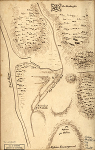
Fort Washington & vicinity
222.
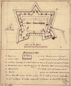
Fort-Griswold
223.
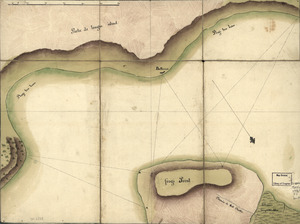
Frog's Point avec batteries de Partie de Longue Island
224.
From Battle of Brandywine
225.
Ft. Provost in 1781
226.
A general plan of Annapolis Royal
227.
Gov. Tryon's expedition to Danbury, 1777
228.
El Guarico, alias, el cavo Frances, es una de las colonias y puertos qe. poseen los Franceses en la parte occidental de la Ysla...
229.
Havana : Vera Cruz
230.
Indiana Fort Wayne : ms. map of Fort Wayne said to have been made on July 18, 1795, for General Anthony Wayne
231.
The Investiture of Charleston, S.C. by the English army, in 1780 : With the position of each corps
232.
Lake Champlain and Lake George, and the country between the Hudson and the lakes on the west, and Connecticut River on the east
233.
Lord Cornwallis surrender, 1781
234.
A map containing part of the Provinces of New York and New Jersey
235.
A map, Middlesex County
236.
Map of a part of west-Florida : overlay down
237.
Map of a part of west-Florida : overlay up
238.
Map of a route through south west Pennsylvania from Fort Loudon, Franklin Co. to Fort Pitt, Pittsburgh
239.
Map of Alexandria, Virginia
240.
Map of British outposts between Burlington and New Bridge, New Jersey, December 1776
‹ Prev
Next ›
1
2
…
8
9
10
11
12
13
14
15
16
…
26
27