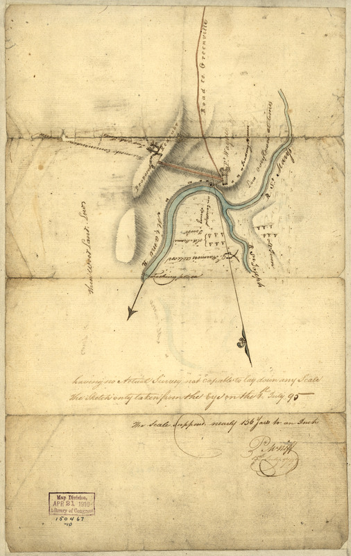
Indiana Fort Wayne : ms. map of Fort Wayne said to have been made on July 18, 1795, for General Anthony Wayne
This map is also available in American Revolutionary Geographies Online (ARGO), a collections portal especially built for material relating to the American Revolutionary War Era. Visit ARGO to learn more about this item and explore the historical geography of North America in the late eighteenth century.
Item Information
- Title:
- Indiana Fort Wayne : ms. map of Fort Wayne said to have been made on July 18, 1795, for General Anthony Wayne
- Creator:
- Neff, P. M.
- Name on Item:
-
by P.M. Neff
- Date:
-
1795
- Format:
-
Maps/Atlases
Manuscripts
- Location:
- Library of Congress Geography and Map Division
- Collection (local):
-
Library of Congress Collection
- Subjects:
-
Fort Wayne (Ind.)--Maps, Manuscript
- Places:
-
Allen (county)Fort Wayne
- Extent:
- 1 ms. map : col. ; 33 x 21 cm.
- Terms of Use:
-
No known copyright restrictions.
This work is licensed for use under a Creative Commons Attribution Non-Commercial Share Alike License (CC BY-NC-SA).

- Scale:
-
Scale [ca. 1:5,616]
- Language:
-
English
- Catalog Record:
-
https://lccn.loc.gov/2007629021
- Notes:
-
Pen-and-ink and watercolors.
Mounted on cloth backing.
"Fort Wayne ... the first American post, built in 1794 and named for Anthony Wayne after his victory at Fallen Timbers, was located across the St. Marys from the old Miami village of Kekionga and the remains of old Fort Miami, at the present intersection of Clay and Berry streets"--Ency. of Historic Forts, p. 281-282.
- Identifier:
-
ct001619


