Toggle navigation
LMEC Home
Exhibitions
Georeferencing
Tools for Teachers
Collections
My Favorites
Sign Up / Log In
Search
Search the map portal
Map Collection
Map Collection
Map Sets
Search
Search
Search for
Search In
All Fields
Creator
Title
Subject
Place
Search All Digital Collections
Advanced Search
498 Results
My Search
Start Over
More Like
commonwealth:q524nb37t
Remove constraint More Like: commonwealth:q524nb37t
Filter your Search
Place
North and Central America
437
United States
311
New York
40
Philadelphia
26
Philadelphia (county)
26
Florida
19
Pennsylvania
18
Canada
17
more
Place
»
Topic
Manuscript maps--Early works to 1800
92
Manuscript maps
21
Philadelphia (Pa.)--Maps--Early works to 1800
21
Gulf Coast (U.S.)--Maps, Manuscript--Early works to 1800
12
Fortification--New York (State)--New York--Maps--Early works to 1800
11
New York (N.Y.)--Buildings, structures, etc--Maps, Manuscript--Early works to 1800
9
New York (N.Y.)--Maps, Manuscript--Early works to 1800
8
Saratoga Campaign, N.Y., 1777--Maps, Manuscript--Early works to 1800
8
more
Topic
»
Date
Date range begin
–
Date range end
Current results range from
1689
to
1899
View distribution
Creator
Hills, John, (Surveyor)
19
Montrésor, John, 1736-1799
16
Bingham, William, 1752-1804
12
Adlum, John, 1759-1836
10
Washington, George, 1732-1799
9
Faden, William, 1749-1836
8
Morgan, Benjamin, (Draftsman)
7
Wangenheim, Friedrich Adam Julius von
7
more
Creator
»
Format
Maps/Atlases
496
Manuscripts
476
Objects/Artifacts
2
Georeferenced
Yes
7
No
491
Collection
American Revolutionary War-Era Maps
496
Library of Congress Collection
480
Maritime Charts and Atlases
32
Urban Maps
19
Norman B. Leventhal Map & Education Center Collection
6
MacLean Collection Map Library
4
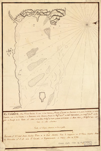
Richard H. Brown Revolutionary War Map Collection at Mount Vernon
4
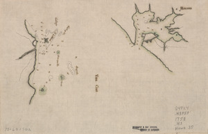
New York Public Library Collection
3
more
Collection
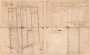
»
Available to use
Creative Commons license
488
No known restrictions
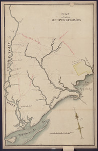
6
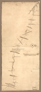
Search Constraints
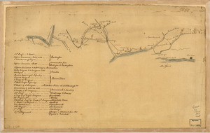
Sort by relevance
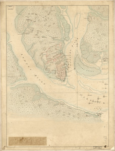
relevance
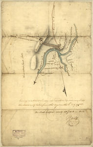
title
date (asc)
date (desc)
Number of results to display per page
20 per page
10
per page
20
per page
50
per page
100
per page
View results as:
grid view
map view
Search Results
121.
From Battle of Brandywine
122.
Ft. Provost in 1781
123.
A general plan of Annapolis Royal
124.
Gov. Tryon's expedition to Danbury, 1777
125.
El Guarico, alias, el cavo Frances, es una de las colonias y puertos qe. poseen los Franceses en la parte occidental de la Ysla...
126.
Havana : Vera Cruz
127.
Indiana Fort Wayne : ms. map of Fort Wayne said to have been made on July 18, 1795, for General Anthony Wayne
128.
The Investiture of Charleston, S.C. by the English army, in 1780 : With the position of each corps
129.
Jefferson, Venango & Armstrong
130.
Lake Champlain and Lake George, and the country between the Hudson and the lakes on the west, and Connecticut River on the east
131.
Land ownership map of the William Bingham estate in Potter County, Pennsylvania
132.
Lines run in the Jersies for determining boundaries between that Province & New York
133.
Lord Cornwallis surrender, 1781
134.
A map containing part of the Provinces of New York and New Jersey
135.
A map, Middlesex County
136.
Map of a part of west-Florida : overlay down
137.
Map of a part of west-Florida : overlay up
138.
Map of a route through south west Pennsylvania from Fort Loudon, Franklin Co. to Fort Pitt, Pittsburgh
139.
Map of Alexandria, Virginia
140.
Map of British outposts between Burlington and New Bridge, New Jersey, December 1776
‹ Prev
Next ›
1
2
3
4
5
6
7
8
9
10
11
…
24
25