Toggle navigation
LMEC Home
Exhibitions
Georeferencing
Tools for Teachers
Collections
My Favorites
Sign Up / Log In
Search
Search the map portal
Map Collection
Map Collection
Map Sets
Search
Search
Search for
Search In
All Fields
Creator
Title
Subject
Place
Search All Digital Collections
Advanced Search
503 Results
My Search
Start Over
More Like
commonwealth:q524nb358
Remove constraint More Like: commonwealth:q524nb358
Filter your Search
Place
North and Central America
442
United States
316
New York
40
Philadelphia
31
Philadelphia (county)
31
Florida
19
Pennsylvania
19
Canada
17
more
Place
»
Topic
Manuscript maps--Early works to 1800
92
Manuscript maps
21
Philadelphia (Pa.)--Maps--Early works to 1800
21
Gulf Coast (U.S.)--Maps, Manuscript--Early works to 1800
12
Fortification--New York (State)--New York--Maps--Early works to 1800
11
New York (N.Y.)--Buildings, structures, etc--Maps, Manuscript--Early works to 1800
9
New York (N.Y.)--Maps, Manuscript--Early works to 1800
8
Saratoga Campaign, N.Y., 1777--Maps, Manuscript--Early works to 1800
8
more
Topic
»
Date
Date range begin
–
Date range end
Current results range from
1689
to
1899
View distribution
Creator
Hills, John, (Surveyor)
19
Montrésor, John, 1736-1799
16
Bingham, William, 1752-1804
12
Adlum, John, 1759-1836
10
Faden, William, 1749-1836
9
Washington, George, 1732-1799
9
Morgan, Benjamin, (Draftsman)
7
Wangenheim, Friedrich Adam Julius von
7
more
Creator
»
Format
Maps/Atlases
501
Manuscripts
476
Objects/Artifacts
2
Georeferenced
Yes
7
No
496
Collection
American Revolutionary War-Era Maps
501
Library of Congress Collection
480
Maritime Charts and Atlases
32
Urban Maps
19
Norman B. Leventhal Map & Education Center Collection
7
Richard H. Brown Revolutionary War Map Collection at Mount Vernon
7
MacLean Collection Map Library
4
New York Public Library Collection
4
more
Collection
»
Available to use
Creative Commons license
492
No known restrictions
7
Search Constraints
Sort by relevance
relevance
title
date (asc)
date (desc)
Number of results to display per page
20 per page
10
per page
20
per page
50
per page
100
per page
View results as:
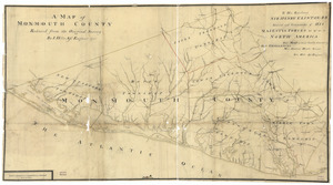
grid view
map view
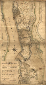
Search Results
141.
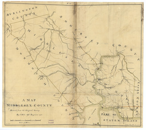
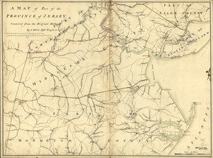
A map, Middlesex County
142.
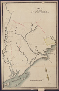
Map of a part of west-Florida : overlay down
143.
Map of a part of west-Florida : overlay up
144.
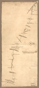
Map of a route through south west Pennsylvania from Fort Loudon, Franklin Co. to Fort Pitt, Pittsburgh
145.
Map of Alexandria, Virginia
146.
Map of British outposts between Burlington and New Bridge, New Jersey, December 1776
147.
Map of coast from southern Florida to central New Jersey
148.
Map of defenses of New York Island from Fort Washington to Fort Independence, with redoubts, etc. planned between
149.
Map of Gen. Sullivan's march from Easton to the Senaca & Cayuga countries
150.
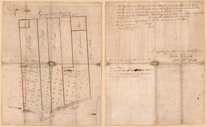
Map of Las Ormigas Grant, Sabine and DeSoto Parishes, Louisiana
151.
Map of military lots, tracts, patents, etc. in western Allegany and Garrett Counties, Maryland
152.
Map of Missouri River and vicinity from Saint Charles, Missouri, to Mandan villages of North Dakota : used by Meriwether Lewis...
153.
Map of Mobile Bay
154.
A map of Monmouth County
155.
Map of Orange and Rockland counties area of New York
156.
A map of part of New-York Island showing a plan of Fort Washington : now call'd Ft. Kniphausen with the rebels lines on the...
157.
Map of part of the city of Washington shewing the situation of the mansion house, grave yard & buildings belonging to Mr....
158.
A map of part of the province of Jersey
159.
A map of Potomack and James rivers in North America shewing their several communications with the navigable waters of the new...
160.
Map of Queens Village or Lloyd Neck in Queens County on the north side of Long Island in the Province (now State) of New York....
‹ Prev
Next ›
1
2
…
4
5
6
7
8
9
10
11
12
…
25
26