Toggle navigation
LMEC Home
Exhibitions
Georeferencing
Tools for Teachers
Collections
My Favorites
Sign Up / Log In
Search
Search the map portal
Map Collection
Map Collection
Map Sets
Search
Search
Search for
Search In
All Fields
Creator
Title
Subject
Place
Search All Digital Collections
Advanced Search
480 Results
My Search
Start Over
More Like
commonwealth:q524n7600
Remove constraint More Like: commonwealth:q524n7600
Filter your Search
Place
North and Central America
416
United States
292
New York
40
Florida
19
Canada
17
Alabama
15
Chatham (county)
15
Savannah
13
more
Place
»
Topic
Manuscript maps--Early works to 1800
92
Manuscript maps
21
Gulf Coast (U.S.)--Maps, Manuscript--Early works to 1800
12
Fortification--New York (State)--New York--Maps--Early works to 1800
11
New York (N.Y.)--Buildings, structures, etc--Maps, Manuscript--Early works to 1800
9
New York (N.Y.)--Maps, Manuscript--Early works to 1800
8
Saratoga Campaign, N.Y., 1777--Maps, Manuscript--Early works to 1800
8
Coasts--Florida--Maps--Early works to 1800
7
more
Topic
»
Date
Date range begin
–
Date range end
Current results range from
1700
to
1899
View distribution
Creator
Hills, John, (Surveyor)
18
Montrésor, John, 1736-1799
16
Bingham, William, 1752-1804
12
Adlum, John, 1759-1836
10
Washington, George, 1732-1799
9
Faden, William, 1749-1836
7
Morgan, Benjamin, (Draftsman)
7
Wangenheim, Friedrich Adam Julius von
7
more
Creator
»
Format
Maps/Atlases
478
Manuscripts
475
Objects/Artifacts
2
Georeferenced
Yes
5
No
475
Collection
American Revolutionary War-Era Maps
480
Library of Congress Collection
480
Maritime Charts and Atlases
31
Urban Maps
15
Available to use
Creative Commons license
480
Search Constraints
Sort by date (asc)
relevance
title
date (asc)
date (desc)
Number of results to display per page
20 per page
10
per page
20
per page
50
per page
100
per page
View results as:
grid view
map view
Search Results
81.
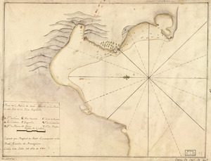
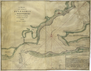
A plan of the harbour of Pensacola in West-Florida
82.
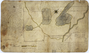
The above plan is a discription of a new township containing the quantity of seven and a half mile of land & water, granted by...
83.
Cantonment of the forces in North America 11th. Octr. 1765
84.
Chart of the sea coast from latitude 27⁰00ʹ00ʺ to 27⁰20ʹ00ʺ, with Little Inlet & River into Hillsborough River ; Chart of the...
85.
Chart of the sea coast from lattde. 26⁰20ʹ00ʺ to 26⁰ & 40ʹ00ʺ with the head of Sharkshead River ; Chart of New Inlet ; Chart of...
86.
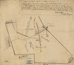
Colchester, May the: 6:th: Day: A.D.: 1765
87.
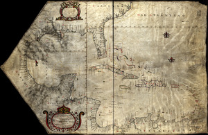
Descripcion de las costas, islas placeres, i bajos delas, Indias Occidentales
88.
A Sketch of the harbour of St. Iago de Cuba
89.
Special chart of Cape Florida belonging to the 13th section
90.
Special chart of Muskito Inlet
91.
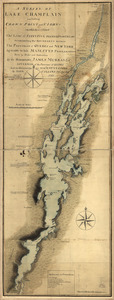
A survey of Lake Champlain including Crown Point and St. Iohn's : on which is fixed the line of forty five degrees north...
92.
The above plan is a discription of a new township called Royalsborough in the county of Cumberland : bounded southeasterly on...
93.
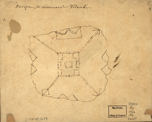
Design for Governor's Island
94.
Plan of Governor's, Kennedy's, and Brown's Islan[ds] and Red Hook together with part of the Bay and soundings : shewing the...
95.
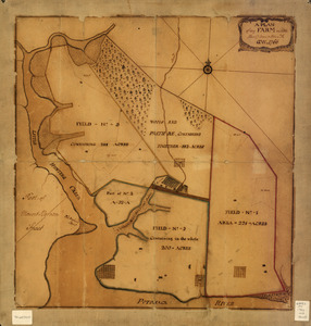
A plan of my farm on Little Huntg. Creek & Potomk. R
96.
River of Ohio
97.
Cantonment of His Majesty's forces in N. America : according to the disposition now made & to be compleated as soon as...
98.
Map showing the west shore of the North or Hudson River
99.
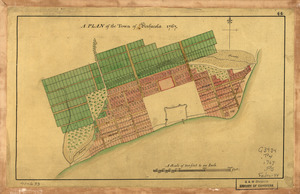
A Plan of the town of Pensacola, 1767
100.
Plano de la Bahía de Ocoa situado en la banda del sur de la Ysla Española
‹ Prev
Next ›
1
2
3
4
5
6
7
8
9
…
23
24

![Chart of the sea coast from latitude 27⁰00ʹ00ʺ to 27⁰20ʹ00ʺ, with Little Inlet & River into Hillsborough River ; Chart of the sea coast from latitude 26⁰40ʹ00ʺ to [27⁰]00ʹ00ʺ, the Leech Shoal & Hillsborough River](https://bpldcassets.blob.core.windows.net/derivatives/images/commonwealth:q524nd97p/image_thumbnail_300.jpg)


![Plan of Governor's, Kennedy's, and Brown's Islan[ds] and Red Hook together with part of the Bay and soundings](https://bpldcassets.blob.core.windows.net/derivatives/images/commonwealth:q524nj614/image_thumbnail_300.jpg)