Toggle navigation
LMEC Home
Exhibitions
Georeferencing
Tools for Teachers
Collections
My Favorites
Sign Up / Log In
Search
Search the map portal
Map Collection
Map Collection
Map Sets
Search
Search
Search for
Search In
All Fields
Creator
Title
Subject
Place
Search All Digital Collections
Advanced Search
8704 Results
My Search
Start Over
More Like
commonwealth:q524n3673
Remove constraint More Like: commonwealth:q524n3673
Filter your Search
Place
North and Central America
5,927
United States
4,845
Massachusetts
2,079
Europe
1,396
Suffolk (county)
1,047
Boston
1,020
Canada
449
Asia
438
more
Place
»
Topic
Boston (Mass.)--Maps
587
United States--Maps
282
Real property--Massachusetts--Boston--Maps
175
Massachusetts--Maps
162
Landowners--Massachusetts--Boston--Maps
133
North America--Maps--Early works to 1800
103
New England--Maps
102
World maps
82
more
Topic
»
Date
Date range begin
–
Date range end
Current results range from
1482
to
2023
View distribution
Creator
United States. Hydrographic Office
595
O.H. Bailey & Co
148
Des Barres, Joseph F. W. (Joseph Frederick Wallet), 1722-1824
123
United States. Post Office Dept
120
Ptolemy, 2nd cent
100
Walling, Henry Francis, 1825-1888
94
Geological Survey (U.S.)
86
Jefferys, Thomas, -1771
85
more
Creator
»
Format
Maps/Atlases
8,644
Manuscripts
218
Prints
56
Books
36
Objects/Artifacts
10
Drawings/Illustrations
8
Posters
5
Georeferenced
Yes
868
No
7,836
Collection
Norman B. Leventhal Map & Education Center Collection
8,701
Boston and New England Maps
2,235
Urban Maps
2,024
Maritime Charts and Atlases
1,083
American Revolutionary War-Era Maps
616
Boston Redevelopment Authority Collection
88
Sidney R. Knafel Map Collection at Phillips Academy
2
Available to use
No known restrictions
8,555
Creative Commons license
50
Search Constraints
Sort by relevance
relevance
title
date (asc)
date (desc)
Number of results to display per page
20 per page
10
per page
20
per page
50
per page
100
per page
View results as:
grid view
map view
Search Results
3341.
Manitoba
3342.
Manitoba : map showing disposition of lands
3343.
Manitoba : map showing disposition of lands
3344.
Manitoba : map showing disposition of lands
3345.
Mansfield, Massachusetts : 1888
3346.
Manufacturing center of Lynn, Mass : 1879
3347.
[Manuscript map of coast from Maine to Delaware]
3348.
[Manuscript map of New England and eastern Canada, showing the routes of Champlain's voyage]
3349.
Manuscript map of the United States
3350.
Manuscript maps of U.S. states
3351.
Manuscript maps of U.S. states, possibly drawn by a schoolchild
3352.
Manuscript plan of the Bulfinch Triangle, Boston, MA : [text]
3353.
Manuscript plan of the Bulfinch Triangle, Boston, MA : [sheet 2]
3354.
Manuscript plan of the Bulfinch Triangle, Boston, MA : [sheet 1]
3355.
Manuscript survey of a property in Kittery, Maine
3356.
A map & chart of the bays harbours post roads and settlements in Passamaquoddy & Machias with the large island of Grand Manan
3357.
Map & profiles of the Vt. Central and Vt. and Canada Railroads
3358.
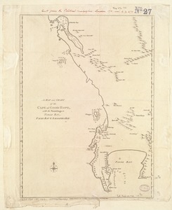
A Map and chart of the Cape of Good Hope, with the soundings in Table Bay, False Bay and Saldanha Bay
3359.
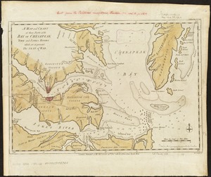
A map and chart of those parts of the Bay of Chesapeak, York and James Rivers which are at present the seat of war
3360.
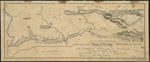
Map and profile of the Champlain Canal as made from Lake Champlain to the Hudson River and surveyed thence to the tide at...
‹ Prev
Next ›
1
2
…
164
165
166
167
168
169
170
171
172
…
435
436


![[Manuscript map of coast from Maine to Delaware]](https://bpldcassets.blob.core.windows.net/derivatives/images/commonwealth:x633f976h/image_thumbnail_300.jpg)
![[Manuscript map of New England and eastern Canada, showing the routes of Champlain's voyage]](https://bpldcassets.blob.core.windows.net/derivatives/images/commonwealth:qb98n8061/image_thumbnail_300.jpg)