Toggle navigation
LMEC Home
Exhibitions
Georeferencing
Tools for Teachers
Collections
My Favorites
Sign Up / Log In
Search
Search the map portal
Map Collection
Map Collection
Map Sets
Search
Search
Search for
Search In
All Fields
Creator
Title
Subject
Place
Search All Digital Collections
Advanced Search
529 Results
My Search
Start Over
More Like
commonwealth:pc28d128q
Remove constraint More Like: commonwealth:pc28d128q
Filter your Search
Place
North and Central America
526
United States
523
Suffolk (county)
516
Boston
515
Massachusetts
207
Roxbury
58
South End
49
Dorchester
46
more
Place
»
Topic
City planning--Massachusetts--Boston--Maps
418
Urban renewal--Massachusetts--Boston--Maps
253
Boston (Mass.)--Maps
137
Land use--Massachusetts--Boston--Maps
101
Buildings--Massachusetts--Boston--Maps
91
Real property--Massachusetts--Boston--Maps
75
Roxbury (Boston, Mass.)--Maps
54
Parks--Massachusetts--Boston--Maps
49
more
Topic
»
Date
Date range begin
–
Date range end
Current results range from
1831
to
2017
View distribution
Creator
Boston Redevelopment Authority
370
Bromley, George Washington
12
Bromley, Walter Scott
12
Downtown Waterfront Corporation
10
G.W. Bromley & Co.
10
Victor Gruen Associates
10
Boston (Mass.). Department of Parks
7
Boston (Mass.). Park Commissioners
7
more
Creator
»
Format
Maps/Atlases
528
Drawings/Illustrations
3
Manuscripts
2
Prints
1
Georeferenced
Yes
7
No
522
Collection
Boston and New England Maps
506
Urban Maps
487
Boston Redevelopment Authority Collection
441
Norman B. Leventhal Map & Education Center Collection
135
Massachusetts Real Estate Atlases
8
Applied Geographics, Inc. Records
1
Available to use
No known restrictions
519
Creative Commons license
1
Search Constraints
Sort by relevance
relevance
title
date (asc)
date (desc)
Number of results to display per page
20 per page
10
per page
20
per page
50
per page
100
per page
View results as:
grid view
map view
Search Results
241.
Land use New York streets - South Cove 1953
242.
Locality map
243.
Long Wharf DEM/BRA master plan : master plan scheme
244.
Long Wharf DEM/BRA master plan : proposed dredging scheme
245.
Long Wharf phase II illustrative plan
246.
Longwood Medical Area
247.
Map of Boston naval shipyard, Boston, Mass. showing conditions on Jan. 1, 1966
248.
Marketplace Center : topographical survey plan
249.
Mass pike air rights study
250.
Mattapan project : building deficiencies
251.
Mattapan project : property map
252.
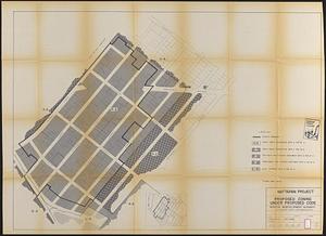
Mattapan project : proposed zoning under proposed code
253.
Mattapan project : right-of-way adjustment plan
254.
Mattapan project : land use and disposition plan
255.
Mattapan project : existing zoning under proposed code
256.
Mattapan project : existing land use
257.
Mattapan project : proposed zoning
258.
Mattapan project : existing zoning
259.
Midtown area plan for the public realm
260.
Midtown improvement area
‹ Prev
Next ›
1
2
…
9
10
11
12
13
14
15
16
17
…
26
27