Toggle navigation
LMEC Home
Exhibitions
Georeferencing
Tools for Teachers
Collections
My Favorites
Sign Up / Log In
Search
Search the map portal
Map Collection
Map Collection
Map Sets
Search
Search
Search for
Search In
All Fields
Creator
Title
Subject
Place
Search All Digital Collections
Advanced Search
481 Results
My Search
Start Over
More Like
commonwealth:n5841g89v
Remove constraint More Like: commonwealth:n5841g89v
Filter your Search
Place
North and Central America
481
United States
478
Suffolk (county)
375
Boston
373
Massachusetts
257
Roxbury
44
Dorchester
31
Middlesex (county)
30
more
Place
»
Topic
Real property--Massachusetts--Boston--Maps
253
Landowners--Massachusetts--Boston--Maps
169
Boston (Mass.)--Maps
142
Buildings--Massachusetts--Boston--Maps
125
City planning--Massachusetts--Boston--Maps
118
Urban renewal--Massachusetts--Boston--Maps
77
Roxbury (Boston, Mass.)--Maps
45
Land tenure--Massachusetts--Boston--Maps
37
more
Topic
»
Date
Date range begin
–
Date range end
Current results range from
1798
to
2023
View distribution
Creator
Boston Redevelopment Authority
122
Bromley, George Washington
79
Bromley, Walter Scott
79
G.W. Bromley & Co.
57
Hopkins, Griffith Morgan, Jr.
27
Geo. H. Walker & Co.
23
Wadsworth, Alexander, 1806-1898
19
Lamb, George
16
more
Creator
»
Format
Maps/Atlases
480
Manuscripts
4
Drawings/Illustrations
1
Georeferenced
Yes
11
No
470
Collection
Boston and New England Maps
328
Urban Maps
325
Norman B. Leventhal Map & Education Center Collection
230
Massachusetts Real Estate Atlases
143
Boston Redevelopment Authority Collection
132
American Revolutionary War-Era Maps
1
Applied Geographics, Inc. Records
1
Available to use
No known restrictions
336
Creative Commons license
2
Search Constraints
Sort by relevance
relevance
title
date (asc)
date (desc)
Number of results to display per page
20 per page
10
per page
20
per page
50
per page
100
per page
View results as:
grid view
map view
Search Results
221.
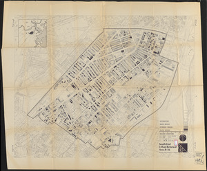
South End urban renewal area R-56 : building conditions
222.
South End urban renewal area R-56 : building conditions
223.
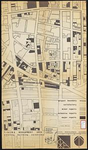
T-N.E.M.C. development area existing building condition
224.
View of the South End
225.
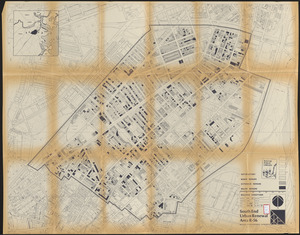
Washington Park urban renewal area : building deficiencies
226.
Washington Park urban renewal area : building deficiencies
227.
Washington Park urban renewal area : building conditions
228.
Washington Park urban renewal area r-24 : buildings with deficiencies
229.
Washington Park urban renewal area r-24 : building condition
230.
Washington Street corridor : South Cove to Forest Hills
231.
Allston-Brighton open space plan site inventory
232.
Brighton and Allston urban design strategy
233.
Brighton park : Brighton district
234.
Map of Brookline and vicinity
235.
North Harvard project area : location map
236.
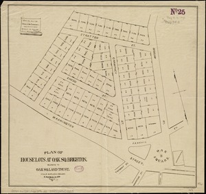
Plan of house lots at Oak Sq. Brighton : belonging to Oak Sq. Land Trust
237.
Plan of house lots in the village of Brighton : upon a part of the well known Winship Estate ... to be sold by public auction...
238.
Plan of the town of Brighton
239.
Topographic map of Brighton and Allston
240.
Atlas, city of Everett, Middlesex County, Massachusetts
‹ Prev
Next ›
1
2
…
8
9
10
11
12
13
14
15
16
…
24
25