Toggle navigation
LMEC Home
Exhibitions
Georeferencing
Tools for Teachers
Collections
My Favorites
Sign Up / Log In
Search
Search the map portal
Map Collection
Map Collection
Map Sets
Search
Search
Search for
Search In
All Fields
Creator
Title
Subject
Place
Search All Digital Collections
Advanced Search
117 Results
My Search
Start Over
More Like
commonwealth:kk91fq66h
Remove constraint More Like: commonwealth:kk91fq66h
Filter your Search
Place
North and Central America
114
United States
99
Boston
49
Suffolk (county)
49
Massachusetts
41
New York
26
Boston Harbor
21
Charleston (county)
14
more
Place
»
Topic
Boston (Mass.)--Maps--Early works to 1800
49
Boston Harbor (Mass.)--Maps--Early works to 1800
19
New York (N.Y.)--Maps--Early works to 1800
18
Charleston (S.C.)--Maps--Early works to 1800
13
Saint Augustine (Fla.)--Maps--Early works to 1800
8
New York Harbor (N.Y. and N.J.)--Maps--Early works to 1800
7
Bunker Hill, Battle of, Boston, Mass., 1775--Maps--Early works to 1800
6
Louisbourg (N.S.)--Maps--Early works to 1800
6
more
Topic
»
Date
Date range begin
–
Date range end
Current results range from
1672
to
1879
View distribution
Creator
Jefferys, Thomas, -1771
10
Sayer, Robert, 1725-1794
9
Bellin, Jacques Nicolas, 1703-1772
7
George, III, King of Great Britain, 1738-1820
5
George, IV, King of Great Britain, 1762-1830
5
Bonner, John, ca. 1643-1726
4
Montrésor, John, 1736-1799
4
Ratzer, Bernard
4
more
Creator
»
Format
Maps/Atlases
117
Manuscripts
10
Georeferenced
Yes
8
No
109
Collection
American Revolutionary War-Era Maps
95
Norman B. Leventhal Map & Education Center Collection
69
Boston and New England Maps
39
Urban Maps
32
Maritime Charts and Atlases
16
Richard H. Brown Revolutionary War Map Collection at Mount Vernon
15
Library of Congress Collection
9
Mapping Boston Collection
8
more
Collection
»
Available to use
No known restrictions
67
Creative Commons license
43
Search Constraints
Sort by relevance
relevance
title
date (asc)
date (desc)
Number of results to display per page
20 per page
10
per page
20
per page
50
per page
100
per page
View results as:
grid view
map view
Search Results
81.
A draught of Boston Harbor by Capt. Cyprian Southake
82.
Die gegend um Boston
83.
Grundriss von der Stadt Boston und ihren Gegenden
84.
Grundriss von der stadt Boston und ihren gegenden
85.
Hafen von Boston
86.
A map of 100 miles round Boston
87.
Map of the environs of Boston
88.
A map of the most inhabited part of New England : containing the provinces of Massachusets Bay and New Hampshire, with the...
89.
A map of the most inhabited part of New England : containing the provinces of Massachusets Bay and New Hampshire, with the...
90.
A new and accurate plan of the town of Boston in New England : A new plan of Boston Harbor from an actual survey
91.
A new and correct plan of the town of Boston
92.
A New Plan of ye Great Town of BOSTON in New England in AMERICA with the many Additionall Buildings & New Streets to the Year,...
93.
A new plan of ye great town of Boston in New England in America, with the many additionall buildings & new streets to the year...
94.
A new plan of ye great town of Boston in New England in America, with the many additionall [sic] buildings, & new streets, to...
95.
Plan de Boston
96.
Plan de Boston
97.
Plan de la ville de Boston
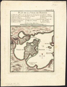
98.
Plan de la ville de Boston
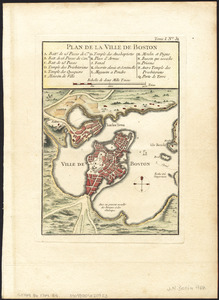
99.
Plan de la ville de Boston
100.
Plan de la ville de Boston et ses environs
‹ Prev
Next ›
1
2
3
4
5
6


![A new plan of ye great town of Boston in New England in America, with the many additionall [sic] buildings, & new streets, to the year, 1769](https://bpldcassets.blob.core.windows.net/derivatives/images/commonwealth:3f462v50z/image_thumbnail_300.jpg)