Toggle navigation
LMEC Home
Exhibitions
Georeferencing
Tools for Teachers
Collections
My Favorites
Sign Up / Log In
Search
Search the map portal
Map Collection
Map Collection
Map Sets
Search
Search
Search for
Search In
All Fields
Creator
Title
Subject
Place
Search All Digital Collections
Advanced Search
8195 Results
My Search
Start Over
More Like
commonwealth:js956m38f
Remove constraint More Like: commonwealth:js956m38f
Filter your Search
Place
North and Central America
4,912
United States
3,602
Suffolk (county)
1,026
Boston
999
Europe
964
Canada
427
France
269
Massachusetts
249
more
Place
»
Topic
Boston (Mass.)--Maps
574
United States--Maps
270
Real property--Massachusetts--Boston--Maps
174
Massachusetts--Maps
160
Landowners--Massachusetts--Boston--Maps
132
North America--Maps--Early works to 1800
103
New England--Maps
99
Europe--Maps
79
more
Topic
»
Date
Date range begin
–
Date range end
Current results range from
1482
to
2023
View distribution
Creator
United States. Hydrographic Office
357
O.H. Bailey & Co
148
Des Barres, Joseph F. W. (Joseph Frederick Wallet), 1722-1824
123
United States. Post Office Dept
120
Ptolemy, 2nd cent
100
Walling, Henry Francis, 1825-1888
94
Jefferys, Thomas, -1771
84
Geological Survey (U.S.)
82
more
Creator
»
Format
Maps/Atlases
8,136
Manuscripts
215
Prints
51
Books
36
Objects/Artifacts
10
Drawings/Illustrations
8
Posters
4
Georeferenced
Yes
869
No
7,326
Collection
Norman B. Leventhal Map Center Collection
8,182
Boston and New England Maps
2,184
Urban Maps
1,925
Maritime Charts and Atlases
750
American Revolutionary War-Era Maps
616
Boston Redevelopment Authority Collection
86
Mapping Boston Collection
19
Sidney R. Knafel Map Collection at Phillips Academy
13
Available to use
No known restrictions
8,022
Creative Commons license
65
Search Constraints
Sort by date (asc)
relevance
title
date (asc)
date (desc)
Number of results to display per page
20 per page
10
per page
20
per page
50
per page
100
per page
View results as:
grid view
map view
Search Results
7241.
Atlas of the city of Boston : South Boston : from actual surveys and official plans
7242.
Atlas of the North Shore : Beverly to Magnolia, Essex Co. Mass. : from official plans and records and actual surveys
7243.
Atlas of the town of Brookline, Norfolk County, Massachusetts : from actual surveys and official plans
7244.
Blue Hills Reservation
7245.
Carte ethnographique de l'Epire du Nord en 1913 = Chartis ethnografikos tis Voreiou Ipeirou to 1913
7246.
The city of Binghamton, Broome Co., N.Y : as extended May 19th, 1908
7247.
Daily Mail map of the battlefields of France
7248.
Deutsch Österreich nach den forderungen des friedensentwurfes der entente
7249.
Electoral votes for President in 1916 and for Congress in 1918 : make your guess for 1920
7250.
Elihu Geer sons' new map of the city of Hartford, Connecticut
7251.
Europe, Africa and the Far East
7252.
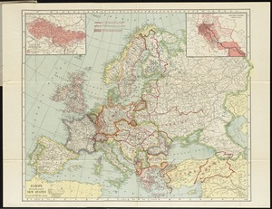
Europe showing the proposed new states
7253.
Industrial map of New England
7254.
J.M.E. Riedel's new street number guide map of Fort Wayne
7255.
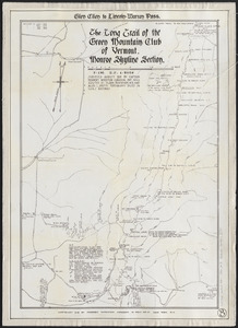
The Long Trail of the Green Mountain Club of Vermont : Monroe Skyline section : Glen Ellen to Lincoln-Warren Pass
7256.
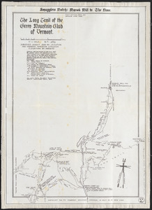
The Long Trail of the Green Mountain Club of Vermont : Smuggler's Notch: Morse's Mill to the Nose
7257.
Manchester, N.H
7258.
Map of Arkansas : from government and other authentic sources
7259.
Map of city of Schenectady and village of Scotia, 1917
7260.
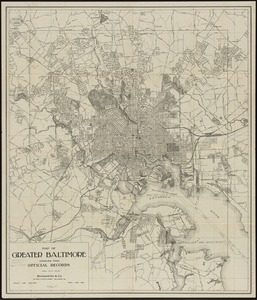
Map of greater Baltimore, compiled from official records : area 91.93 sq. mi
‹ Prev
Next ›
1
2
…
359
360
361
362
363
364
365
366
367
…
409
410