Carte ethnographique de l'Epire du Nord en 1913 = Chartis ethnografikos tis Voreiou Ipeirou to 1913
Item Information
- Title:
- Carte ethnographique de l'Epire du Nord en 1913 = Chartis ethnografikos tis Voreiou Ipeirou to 1913
- Issuing body:
- Greece. Stratos
- Cartographer:
- Botzaris, Dimitrios, 1808-1892
- Name on Item:
-
G.Q.G. Hellénique le 26 juillet 1919, le chef du 2ème Bureau Lt-Colonel Botzaris ; vu le chef d'Etat-Major, colonel Pangalos ; j'approuve et ordonne l'impression, Général Paraskevopoulo, cant. en chef l'Armée hellénique
- Date:
-
[1919]
- Format:
-
Maps/Atlases
- Location:
-
Boston Public Library
Norman B. Leventhal Map & Education Center - Collection (local):
-
Norman B. Leventhal Map & Education Center Collection
- Subjects:
-
Epirus (Greece and Albania)--Maps
Ethnography--Epirus (Greece and Albania)--Maps
- Places:
-
Epirus (area)
- Extent:
- 1 map : color ; 80 x 67 cm, on sheet 103 x 72 cm
- Terms of Use:
-
No known copyright restrictions.
No known restrictions on use.
- Publisher:
-
Thessalonikē :
Lith. Pana & Sia.
- Scale:
-
Scale 1:200,000
- Language:
-
French
Greek, Modern (1453-)
- Notes:
-
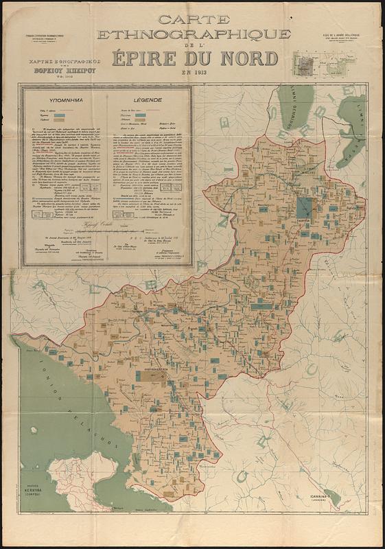
A work of cartographic propaganda submitted to the Paris Peace Conference (1919) as part of a successful lobbying campaign to have the region awarded to Greece.
Prime meridian: [Ferro?].
Indicates Greek and Albanian populations in cities and towns.
Shows the boundaries of Northern Epirus, with a blue line separating a northern region inhabited almost exclusively by Albanians.
Includes explanatory text and location map.
- Notes (date):
-
This date is inferred.
- Notes (language):
-
In French and Greek.
- Identifier:
-
06_01_017829
- Call #:
-
G6831.E1 1913 .G74
- Barcode:
-
39999085963211


