Toggle navigation
LMEC Home
Exhibitions
Georeferencing
Tools for Teachers
Collections
My Favorites
Sign Up / Log In
Search
Search the map portal
Map Collection
Map Collection
Map Sets
Search
Search
Search for
Search In
All Fields
Creator
Title
Subject
Place
Search All Digital Collections
Advanced Search
9021 Results
My Search
Start Over
More Like
commonwealth:js956j09k
Remove constraint More Like: commonwealth:js956j09k
Filter your Search
Place
North and Central America
6,248
United States
5,131
Massachusetts
2,098
Europe
1,396
Suffolk (county)
1,068
Boston
1,036
Canada
463
Asia
438
more
Place
»
Topic
Boston (Mass.)--Maps
595
United States--History--Revolution, 1775-1783--Maps
330
United States--Maps
283
Real property--Massachusetts--Boston--Maps
175
Massachusetts--Maps
163
Landowners--Massachusetts--Boston--Maps
133
New England--Maps
104
North America--Maps--Early works to 1800
103
more
Topic
»
Date
Date range begin
–
Date range end
Current results range from
1482
to
2023
View distribution
Creator
United States. Hydrographic Office
595
O.H. Bailey & Co
148
Des Barres, Joseph F. W. (Joseph Frederick Wallet), 1722-1824
124
United States. Post Office Dept
120
Ptolemy, 2nd cent
100
Walling, Henry Francis, 1825-1888
94
Geological Survey (U.S.)
86
Jefferys, Thomas, -1771
86
more
Creator
»
Format
Maps/Atlases
8,956
Manuscripts
219
Prints
56
Books
36
Drawings/Illustrations
13
Objects/Artifacts
10
Posters
5
Georeferenced
Yes
872
No
8,149
Collection
Norman B. Leventhal Map & Education Center Collection
8,695
Boston and New England Maps
2,232
Urban Maps
2,022
Maritime Charts and Atlases
1,083
American Revolutionary War-Era Maps
942
William L. Clements Library Collection
305
Boston Redevelopment Authority Collection
87
Maps from AAS
8
more
Collection
»
Available to use
No known restrictions
8,555
Creative Commons license
52
Search Constraints
Sort by relevance
relevance
title
date (asc)
date (desc)
Number of results to display per page
20 per page
10
per page
20
per page
50
per page
100
per page
View results as:
grid view
map view
Search Results
241.
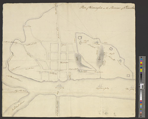
Plan of Wilmington in the province of Nth: Carolina
242.
Plan von dem schiff-bauplatz bei Hallifax in Neuscholland
243.
Plan von Halifax in Nord-America
244.
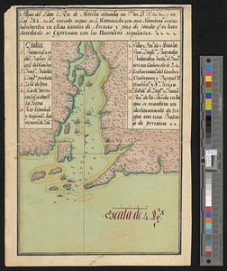
Plano del lago o rio de Movila situada su pta. en lt. N 30.10 en logd. 284.40 ms. Sacado se a consido consus nombres costas...
245.
Plano del puerto de Panzacola en el qe. se manifiestan las marchas, campamentos y ataque de las tropas Espanolas : al mando del...
246.
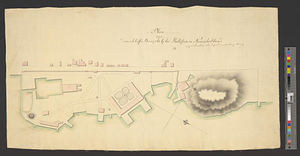
Portsmouth
247.
Portsmouth and Norfolk
248.
Position of the army near Iron Hill
249.
Position of the troops under Earl Cornwallis on the 28 and 29th September 1781; when the enemy first appeared
250.
Positions of the British troops between the Hudson River and the Bronx River at Valentine's Hill
251.
The principal part of the province of New Jersey shewing the road and distances to the several towns between the North River...
252.
Progress of the British army from Elk River to Philadelphia, 1777
253.
Proposed fortifications for Savannah
254.
Proposed redoubt at Canoe Place
255.
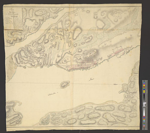
Providence and Newport
256.
The Rahway River valley, ca. 1780
257.
Reconnoissance des ouvrages de Ouët Point : etablis pour couvrir et assurer la communication des états du nord avec ceux du...
258.
Region between Westchester Creek and the Bronx River
259.
The road from New Bridge and Hackinsack to Burlington
260.
A rough draught of New Haven fort
‹ Prev
Next ›
1
2
…
9
10
11
12
13
14
15
16
17
…
451
452