Toggle navigation
LMEC Home
Exhibitions
Georeferencing
Tools for Teachers
Collections
My Favorites
Sign Up / Log In
Search
Search the map portal
Map Collection
Map Collection
Map Sets
Search
Search
Search for
Search In
All Fields
Creator
Title
Subject
Place
Search All Digital Collections
Advanced Search
322 Results
My Search
Start Over
More Like
commonwealth:j38608711
Remove constraint More Like: commonwealth:j38608711
Filter your Search
Place
North America
171
North and Central America
130
United States
58
Canada
39
Virginia
32
New England
28
Massachusetts
17
Maryland
14
more
Place
»
Topic
North America--Maps--Early works to 1800
180
Canada--Maps--Early works to 1800
41
Virginia--Maps--Early works to 1800
32
New England--Maps--Early works to 1800
22
United States--Maps--Early works to 1800
19
Great Britain--Colonies--America--Maps--Early works to 1800
16
Maryland--Maps--Early works to 1800
15
World maps--Early works to 1800
13
more
Topic
»
Date
Date range begin
–
Date range end
Current results range from
1482
to
1990
View distribution
Creator
Jefferys, Thomas, -1771
19
Sayer, Robert, 1725-1794
15
Bellin, Jacques Nicolas, 1703-1772
14
Mitchell, John, 1711-1768
13
Moll, Herman, d. 1732
12
Anville, Jean Baptiste Bourguignon d', 1697-1782
9
Hinton, John, -1781
7
Kitchin, Thomas, 1718-1784
7
more
Creator
»
Format
Maps/Atlases
322
Manuscripts
4
Books
1
Georeferenced
Yes
14
No
308
Collection
American Revolutionary War-Era Maps
182
Norman B. Leventhal Map Center Collection
148
Sidney R. Knafel Map Collection at Phillips Academy
87
New York Public Library Collection
36
Richard H. Brown Revolutionary War Map Collection at Mount Vernon
25
Mapping Boston Collection
9
Library and Archives Canada Collection
8
New-York Historical Society Collection
5
more
Collection
»
Available to use
No known restrictions
144
Creative Commons license
79
Search Constraints
Sort by relevance
relevance
title
date (asc)
date (desc)
Number of results to display per page
20 per page
10
per page
20
per page
50
per page
100
per page
View results as:
grid view
map view
Search Results
21.
Carte de la Virginie et du Maryland
22.
Carte des environs du Fort Pitt et de la nouvelle province Indiana : dediée a M. Franklin
23.
A draught of Virginia from the Capes to York in York River and to Kuiquotan or Hamton in James River
24.
A map of the country between Will's Creek & Monongahela River shewing the rout and encampments of the English army in 1755
25.
A map of the country between Will's Creek & Monongahela River shewing the rout and encampments of the English army in 1755
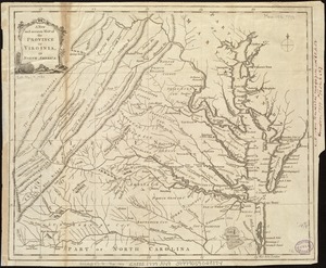
26.
A map of the most inhabited part of Virginia containing the whole province of Maryland : with part of Pensilvania, New Jersey...
27.
A map of the most inhabited part of Virginia containing the whole province of Maryland with part of Pensilvania, New Jersey and...
28.
A map of the most inhabited part of Virginia containing the whole province of Maryland with part of Pensilvania, New Jersey and...
29.
A map of the seat of war in the southern part of Virginia, North Carolina, and the northern part of South Carolina
30.
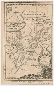
Map of the western parts of the colony of Virginia
31.
Map of the western parts of the colony of Virginia, as far as the Mississipi
32.
MAP of the Western parts of the COLONY of VIRGINIA, as far as the Mississipi
33.
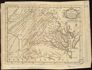
A map of Virginia and Maryland
34.
A new and accurate map of the province of Virginia in North America
35.
A New and accurate map of Virginia : and part of Maryland and Pennsylvania
36.
A new map of Virginia from the best authorities
37.
A new map of Virginia, Mary-land and the improved parts of Penn-sylvania & New Jersey
38.
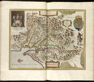
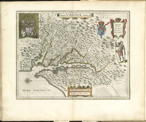
Nova Virginiae tabula
39.
Nova Virginiae tabula
40.
A plan of the entrance of Chesapeak Bay, with James and York Rivers : wherein are shown the respective positions (in the...
‹ Prev
Next ›
1
2
3
4
5
6
…
16
17