Toggle navigation
LMEC Home
Exhibitions
Georeferencing
Tools for Teachers
Collections
My Favorites
Sign Up / Log In
Search
Search the map portal
Map Collection
Map Collection
Map Sets
Search
Search
Search for
Search In
All Fields
Creator
Title
Subject
Place
Search All Digital Collections
Advanced Search
224 Results
My Search
Start Over
More Like
commonwealth:hq37vv40p
Remove constraint More Like: commonwealth:hq37vv40p
Filter your Search
Place
North and Central America
181
United States
152
New England
100
Northeastern United States
43
Middle Atlantic
37
Canada
27
Massachusetts
27
New York
23
more
Place
»
Topic
New England--Maps--Early works to 1800
97
Northeastern States--Maps--Early works to 1800
46
Middle Atlantic States--Maps--Early works to 1800
38
Canada--Maps--Early works to 1800
14
New York (State)--Maps--Early works to 1800
14
North America--Maps--Early works to 1800
13
World maps--Early works to 1800
13
Massachusetts--Maps--Early works to 1800
10
more
Topic
»
Date
Date range begin
–
Date range end
Current results range from
1482
to
1999
View distribution
Creator
Jefferys, Thomas, -1771
11
Evans, Lewis, 1700?-1756
8
Jefferys, Thomas, d. 1771
8
Bowles, Carington, 1724-1793
7
Bellin, Jacques Nicolas, 1703-1772
6
Sayer, Robert, 1725-1794
6
Lodge, John, -1796
5
Ortelius, Abraham, 1527-1598
5
more
Creator
»
Format
Maps/Atlases
224
Manuscripts
3
Books
1
Georeferenced
Yes
19
No
205
Collection
American Revolutionary War-Era Maps
113
Sidney R. Knafel Map Collection at Phillips Academy
87
Norman B. Leventhal Map & Education Center Collection
85
Boston and New England Maps
30
Mapping Boston Collection
28
MacLean Collection Map Library
17
Maritime Charts and Atlases
15
New York Public Library Collection
14
more
Collection
»
Available to use
No known restrictions
60
Creative Commons license
58
Search Constraints
Sort by relevance
relevance
title
date (asc)
date (desc)
Number of results to display per page
20 per page
10
per page
20
per page
50
per page
100
per page
View results as:
grid view
map view
Search Results
81.
Part of North America : comprehending the course of Ohio, New England, New York, New Jersey, Pennsylvania, Maryland, Virginia,...
82.
Partie occidentale de la Virginie, Pensylvanie, Maryland, et Caroline septle. la Rivière d'Ohio, et toutes celles qui s'y...
83.
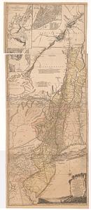
La Pensilvania, la Nuova York, il Jersey Settentrio[na]le : con la parte occidentale del Connecticut, Massachusset-s-bay e...
84.
Pensylvania Nova Jersey et Nova York cum Regionibus ad Fluvium Delaware in America sitis
85.
Position der Koenigl;Grosbrittanischen und derer vereinigten provinzial armée in New York und dem Jerseys in Nord America im...
86.
The provinces of New York and New Jersey : with part of Pensilvania, and the Province of Quebec
87.
The provinces of New York and New Jersey; with part of Pensilvania, and the province of Quebec
88.
Virginia, Maryland, Pennsilvania, east & west New Jarsey
89.
An Accurate map of New Hampshire in New England, from a late survey
90.
An accurate map of Rhode Island, part of Connecticut and Massachusets, shewing Admiral Arbuthnot's station in blocking up...
91.
An accurate map of the four New England states : shewing in a distinct manner all the mountains, forts, rivers, swamps,...
92.
An actual survey of the sea coast from New York to the I. Cape Brition : with tables of the direct and thwart courses &...
93.
Bowles's map of the seat of war in New England, comprehending the provinces of Massachusets Bay, and New Hampshire : with the...
94.
Bowles's new pocket map of the most inhabited part of New England : comprehending the provinces of Massachusets Bay and New...
95.
Carta particolare della nuoua Belgia è parte della nuoua Anglia
96.
Carte de la Nouvelle Angleterre, comprenant les etats de Massachusets Bay, N. Hamp Shire, Connecticut et Rhode Island
97.
Carte d'une partie de l'Amérique Septentrionale : pour servir à l'intellegence du mémoire sur les prétentions des Anglois...
98.
Carte generale du Canada ou Nouvelle France
99.
A chart of the coast of America from New found Land to Cape Cod
100.
A chart of the coast of New England from the South Shoal to Cape Sable including Georges Bay from Holland & actual surveys
‹ Prev
Next ›
1
2
3
4
5
6
7
8
9
…
11
12


![La Pensilvania, la Nuova York, il Jersey Settentrio[na]le](https://bpldcassets.blob.core.windows.net/derivatives/images/commonwealth:z603vq53g/image_thumbnail_300.jpg)