Toggle navigation
LMEC Home
Exhibitions
Georeferencing
Tools for Teachers
Collections
My Favorites
Sign Up / Log In
Search
Search the map portal
Map Collection
Map Collection
Map Sets
Search
Search
Search for
Search In
All Fields
Creator
Title
Subject
Place
Search All Digital Collections
Advanced Search
8853 Results
My Search
Start Over
More Like
commonwealth:cj82m568c
Remove constraint More Like: commonwealth:cj82m568c
Filter your Search
Place
North and Central America
6,080
United States
4,926
Massachusetts
2,080
Europe
1,397
Suffolk (county)
1,046
Boston
1,019
Canada
540
Asia
438
more
Place
»
Topic
Boston (Mass.)--Maps
586
United States--Maps
284
Real property--Massachusetts--Boston--Maps
175
Massachusetts--Maps
163
United States--History--French and Indian War, 1754-1763--Maps
162
Landowners--Massachusetts--Boston--Maps
133
New England--Maps
104
North America--Maps--Early works to 1800
103
more
Topic
»
Date
Date range begin
–
Date range end
Current results range from
1482
to
2023
View distribution
Creator
United States. Hydrographic Office
595
O.H. Bailey & Co
148
Des Barres, Joseph F. W. (Joseph Frederick Wallet), 1722-1824
123
United States. Post Office Dept
120
Ptolemy, 2nd cent
100
Jefferys, Thomas, -1771
98
Walling, Henry Francis, 1825-1888
94
Geological Survey (U.S.)
86
more
Creator
»
Format
Maps/Atlases
8,792
Manuscripts
215
Prints
57
Books
36
Objects/Artifacts
10
Drawings/Illustrations
8
Posters
5
Georeferenced
Yes
869
No
7,984
Collection
Norman B. Leventhal Map & Education Center Collection
8,694
Boston and New England Maps
2,233
Urban Maps
2,023
Maritime Charts and Atlases
1,083
American Revolutionary War-Era Maps
774
William L. Clements Library Collection
149
Boston Redevelopment Authority Collection
87
Richard H. Brown Revolutionary War Map Collection at Mount Vernon
5
more
Collection
»
Available to use
No known restrictions
8,553
Creative Commons license
52
Search Constraints
Sort by relevance
relevance
title
date (asc)
date (desc)
Number of results to display per page
20 per page
10
per page
20
per page
50
per page
100
per page
View results as:
grid view
map view
Search Results
7441.
A sectional map of Massachusetts, engraved expressly for Chapin's farm advertiser, 1871 : including the proposed Massachusetts...
7442.
Sectional map of the northern portion of Vancouver Island
7443.
Sectional map of the Old Colony Railroad South Shore, Nantasket Beach and Plymouth lines
7444.
Sections of soundings made by order of the Harbor Committee of 1852
7445.
Secunda Affrice tabula continet Affricam & insulae que circa ipsam sunt
7446.
Secunda Africae tabula
7447.
Secunda Asiae tabula
7448.
Secunda Asie tabula continet Sarmatia ipsius
7449.
Secunda Europae tabula
7450.
Secunda Europe tabula
7451.
Segusiani : partie du dioecese et archevesche de Lyon : Le Bas Forez et Beaujolois : eslectons de Roanne et de Villefranche
7452.
Segusiani : partie du dioese et archevche de Lyon : le Lyonnois et le haut forez : eslections de Lyon, de St. Chamont, et de...
7453.
Selected hurricanes affecting the southern United States 1954-1977
7454.
Senones : Evesché d'Auxerre : Comté et Ballge d'Auxerre : Eslectons. de Clamecy, de Gien, de la Charité, et de Vezelay
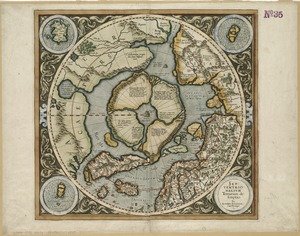
7455.
Septentrionalium terrarum descriptio
7456.
Septima Asia tabula continet Margianam, Bactrianam, Sogdianos, Sacas & Scythiam intra Imaū mōtē
7457.
Septima Asiae tabula
7458.
Septima Europa tabula continet Sardininiam & Sicilia insulas
7459.
Septima Europae tabula
7460.
Ser. Reg. Caroli Gustavi victoriolus e Sialandia disccssus facta pace Rothschildenli d. 5 Martij 1658 ; Ser. Reg. Sueciæ...
‹ Prev
Next ›
1
2
…
369
370
371
372
373
374
375
376
377
…
442
443