Toggle navigation
LMEC Home
Exhibitions
Georeferencing
Tools for Teachers
Collections
My Favorites
Sign Up / Log In
Search
Search the map portal
Map Collection
Map Collection
Map Sets
Search
Search
Search for
Search In
All Fields
Creator
Title
Subject
Place
Search All Digital Collections
Advanced Search
8769 Results
My Search
Start Over
More Like
commonwealth:cj82m2577
Remove constraint More Like: commonwealth:cj82m2577
Filter your Search
Place
North and Central America
5,992
United States
4,914
Massachusetts
2,083
Europe
1,396
Suffolk (county)
1,048
Boston
1,021
Canada
470
Asia
438
more
Place
»
Topic
Boston (Mass.)--Maps
588
United States--Maps
330
Real property--Massachusetts--Boston--Maps
175
Massachusetts--Maps
164
Landowners--Massachusetts--Boston--Maps
133
New England--Maps
127
North America--Maps--Early works to 1800
103
Europe--Maps
79
more
Topic
»
Date
Date range begin
–
Date range end
Current results range from
1482
to
2023
View distribution
Creator
United States. Hydrographic Office
595
O.H. Bailey & Co
148
Des Barres, Joseph F. W. (Joseph Frederick Wallet), 1722-1824
123
United States. Post Office Dept
120
Ptolemy, 2nd cent
100
Walling, Henry Francis, 1825-1888
94
Geological Survey (U.S.)
87
Jefferys, Thomas, -1771
86
more
Creator
»
Format
Maps/Atlases
8,709
Manuscripts
215
Prints
56
Books
36
Objects/Artifacts
10
Drawings/Illustrations
8
Posters
5
Georeferenced
Yes
873
No
7,896
Collection
Norman B. Leventhal Map & Education Center Collection
8,704
Boston and New England Maps
2,239
Urban Maps
2,023
Maritime Charts and Atlases
1,083
American Revolutionary War-Era Maps
674
Boston Redevelopment Authority Collection
87
American Antiquarian Society Collection
29
William L. Clements Library Collection
16
more
Collection
»
Available to use
No known restrictions
8,560
Creative Commons license
53
Search Constraints
Sort by relevance
relevance
title
date (asc)
date (desc)
Number of results to display per page
20 per page
10
per page
20
per page
50
per page
100
per page
View results as:
grid view
map view
Search Results
7201.
Real estate on Milk & Oliver Sts. belonging to the Boston Mang. Co. & Merrimack Mang. Co. to be sold on Friday, March 15th 1844...
7202.
Rebel line of works at Blakely captured by the Army of West Miss., April 9, 1865
7203.
Recens edita totius Novi Belgii, in America Septentrionali siti
7204.
Recens elaborata mappa geographica regni Brasiliae in America Meridionali maxime celebris
7205.
Recentis Romae ichnographia et hypsographia sive planta et facies ad magnificentiam qua sub Alexandro VII P.M. urbs ipsa...
7206.
Recentissima novi orbis sive Americae septentrionalis et meridionalis tabula
7207.
Recentissima novi orbis sive Americae septentrionalis et meridionalis tabula
7208.
Recentissima novi orbis, sive Americae Septentrionalis et Meridionalis tabula
7209.
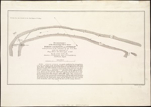
Reconnaissance of the battle field at Bull Run, Va., fought July 21, 1861
7210.
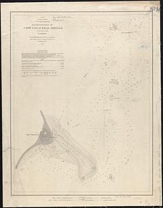
Reconnoissance of Cape Canaveral Shoals on the eastern coast of Florida
7211.
A reconnoissance of the Minnay Sotor Watapāh; or St. Peter's River to its sources : made in the year 1835
7212.
Reconnoissance of the Mississippi River below Forts Jackson and St. Philip : made previous to the reduction by the U.S. Fleet,...
7213.
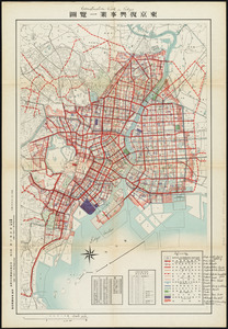
Reconstruction work in Tokyo
7214.
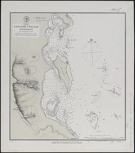
Red Sea, Safájah Island anchorages : from a British survey in 1872
7215.
Red Sea, Strait of Jubal
7216.
Red Sea, Suez Bay : from British surveys in 1870, corrected to 1872
7217.
Reg Manning's table-top argu-map of the world
7218.
Region embraced in the operations of the armies against Richmond and Petersburg
7219.
Region embraced in the operations of the armies against Richmond and Petersburg
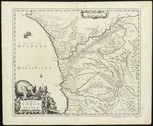
7220.
Regna Congo et Angola
‹ Prev
Next ›
1
2
…
357
358
359
360
361
362
363
364
365
…
438
439