Toggle navigation
LMEC Home
Exhibitions
Georeferencing
Tools for Teachers
Collections
My Favorites
Sign Up / Log In
Search
Search the map portal
Map Collection
Map Collection
Map Sets
Search
Search
Search for
Search In
All Fields
Creator
Title
Subject
Place
Search All Digital Collections
Advanced Search
471 Results
My Search
Start Over
More Like
commonwealth:bv73fh39r
Remove constraint More Like: commonwealth:bv73fh39r
Filter your Search
Place
North and Central America
468
United States
465
Suffolk (county)
458
Boston
457
Massachusetts
158
South End
49
Roxbury
47
Downtown Boston
40
more
Place
»
Topic
City planning--Massachusetts--Boston--Maps
418
Urban renewal--Massachusetts--Boston--Maps
253
Boston (Mass.)--Maps
122
Land use--Massachusetts--Boston--Maps
101
Buildings--Massachusetts--Boston--Maps
81
Real property--Massachusetts--Boston--Maps
49
Roxbury (Boston, Mass.)--Maps
43
South End (Boston, Mass.)--Maps
42
more
Topic
»
Date
Date range begin
–
Date range end
Current results range from
1835
to
2003
View distribution
Creator
Boston Redevelopment Authority
370
Downtown Waterfront Corporation
10
Victor Gruen Associates
10
Boston (Mass.). Parks and Recreation Department
8
Sasaki Associates
6
Boston (Mass.). Department of Parks
5
Charles A. Maguire and Associates
5
I.M. Pei & Associates
5
more
Creator
»
Format
Maps/Atlases
470
Drawings/Illustrations
3
Manuscripts
1
Prints
1
Georeferenced
Yes
2
No
469
Collection
Boston and New England Maps
463
Urban Maps
449
Boston Redevelopment Authority Collection
439
Norman B. Leventhal Map & Education Center Collection
85
David Judkins Weaver Papers
1
Available to use
No known restrictions
470
Search Constraints
Sort by relevance
relevance
title
date (asc)
date (desc)
Number of results to display per page
20 per page
10
per page
20
per page
50
per page
100
per page
View results as:
grid view
map view
Search Results
441.
Downtown Boston
442.
Index map of watersheds showing sanitary districts and bacteriological sampling stations
443.
A land ownership map for the Longwood Medical Area as of January 1980
444.
Massachusetts highway program for 1965
445.
The Massachusetts interstate highway program
446.
Massachusetts outdoor recreation plan 1966 : public outdoor recreation areas
447.
Master highway plan metropolitan Boston showing the Massachusetts turnpike, route 128 (circumferential highway), Boston central...
448.
Mother Brook recreation study
449.
Neighborhood boundaries 1980
450.
New public library building, Boston, Mass. : 1/4 inch scale drawing for foundations of columns at Dartmouth Street entrance
451.
Off-street parking inventory within Boston proper
452.
Plan of the route of pipes from Jamaica Pond, in Roxbury to the reservoir, in Boston
453.
Port facilities at Boston, MA
454.
Public open space city of Boston
455.
Public outdoor recreation master plan
456.
Relationship between selected recreation sites and public transportation facilities Boston metropolitan area 1971
457.
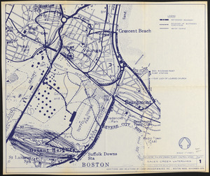
Revere, Sales Creek - flood control study
458.
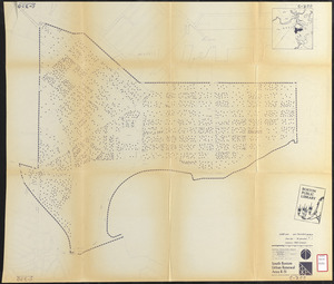
Roxbury
459.
South Boston urban renewal area R-51 : existing population density
460.
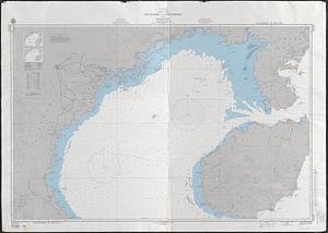
South China Sea, Gulf of Tonkin, Vietnam--China, C'ua Nhuong to Leizhou Bandao including Hainan Dao
‹ Prev
Next ›
1
2
…
19
20
21
22
23
24