Toggle navigation
LMEC Home
Exhibitions
Georeferencing
Tools for Teachers
Collections
My Favorites
Sign Up / Log In
Search
Search the map portal
Map Collection
Map Collection
Map Sets
Search
Search
Search for
Search In
All Fields
Creator
Title
Subject
Place
Search All Digital Collections
Advanced Search
425 Results
My Search
Start Over
More Like
commonwealth:8336pn34t
Remove constraint More Like: commonwealth:8336pn34t
Filter your Search
Place
North and Central America
369
United States
231
Canada
93
North America
80
New York
24
Pennsylvania
19
Asia
17
Great Lakes Region
16
more
Place
»
Topic
Canada--Maps--Early works to 1800
79
North America--Maps--Early works to 1800
71
United States--Maps--Early works to 1800
55
Great Lakes Region (North America)--Maps--Early works to 1800
17
Pennsylvania--Maps--Early works to 1800
12
New England--Maps--Early works to 1800
11
Northeastern States--Maps--Early works to 1800
11
New York (State)--Maps--Early works to 1800
9
more
Topic
»
Date
Date range begin
–
Date range end
Current results range from
1618
to
1999
View distribution
Creator
Bellin, Jacques Nicolas, 1703-1772
25
Jefferys, Thomas, -1771
20
Robert Sayer and John Bennett (Firm)
16
Faden, William, 1749-1836
14
Gibson, J. (John), active 1750-1792
14
Carleton, Osgood, 1742-1816
13
Bowles, Carington, 1724-1793
10
Carey, Mathew, 1760-1839
10
more
Creator
»
Format
Maps/Atlases
423
Manuscripts
5
Paintings
3
Ephemera
1
Objects/Artifacts
1
Prints
1
Georeferenced
Yes
1
No
424
Collection
MacLean Collection Map Library
379
American Revolutionary War-Era Maps
365
Norman B. Leventhal Map & Education Center Collection
26
Library and Archives Canada Collection
8
New York Public Library Collection
3
Richard H. Brown Revolutionary War Map Collection at Mount Vernon
3
Boston Athenaeum, Cartographic Collection
1
Harvard Map Collection
1
more
Collection
»
Available to use
No known restrictions
26
Creative Commons license
10
Search Constraints
Sort by relevance
relevance
title
date (asc)
date (desc)
Number of results to display per page
20 per page
10
per page
20
per page
50
per page
100
per page
View results as:
grid view
map view
Search Results
61.
Carte minéralogique, où l'on voit la nature des terreins du Canada et de la Louisiane
62.
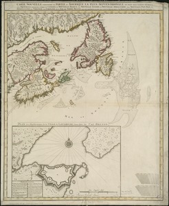
Carte nouvelle contenant la partie d'Amerique la plus septentrionale, ou sont exactement dêcrites les provinces suivantes...
63.
Cours du fleuve St. Laurent : deuxieme feuille : depuis Quebec jusqu'au havre des Papinachouas
64.
Cours du fleuve St. Laurent : premiere feuille : contenant depuis le Lac Ontario jusqu'a Quebec
65.
Cours du fleuve St. Laurent : troisieme feuille : depuis le mont Camille jusqu'a l'isle d'Anticosti
66.
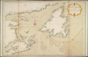
Golphe de Saint Laurent, contenant l'Isle de Terreneuve, Detroit de Belle-Isle, entrée du Fleuve St. Laurent, Isle Royale, et...
67.
A map of Canada and the north part of Louisiana with the adjacent countrys
68.
A map of part of Canada for the use of His Majesty's Secretary of State, compiled in the Surveyor Generals Office, pursuant to...
69.
A map of the British and French dominions in North America : with the roads, distances, limits, and extent of the settlements,...
70.
Map of the United States in North America : with the British, French and Spanish dominions adjoining, according to the treaty...
71.
A New and correct map of the British colonies in North America comprehending eastern Canada with the province of Quebec, New...
72.
A new chart of the coast of New England, Nova Scotia, New France or Canada, with the islands of Newfoundld. Cape Breton St....
73.
A new map of North America
74.
A New map of North America with the West India Islands : divided according to the preliminary articles of peace, signed at...
75.
A new map of Nova Scotia and Cape Breton Island : with the adjacent parts of New England and Canada composed from a great...
76.
A new map of the United States of North America with the British dominions on that continent &c
77.
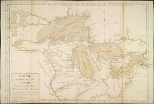
Partie occidentale du Canada contenant les lacs Ontario, Huron, Erié, et Lac Superieur
78.
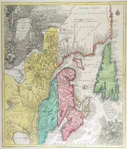
Partie orientale de la Nouvelle France ou du Canada : avec l'isle de Terre-Neuve et de Nouvelle Escosse, Acadie et Nouv....
79.
Partie orientale de la Nouvelle France ou du Canada
80.
Partie orientale de la Nouvelle France ou du Canada
‹ Prev
Next ›
1
2
3
4
5
6
7
8
…
21
22