Toggle navigation
LMEC Home
Exhibitions
Georeferencing
Tools for Teachers
Collections
My Favorites
Sign Up / Log In
Search
Search the map portal
Map Collection
Map Collection
Map Sets
Search
Search
Search for
Search In
All Fields
Creator
Title
Subject
Place
Search All Digital Collections
Advanced Search
8778 Results
My Search
Start Over
More Like
commonwealth:8336h366x
Remove constraint More Like: commonwealth:8336h366x
Filter your Search
Place
North and Central America
6,009
United States
4,906
Massachusetts
2,149
Europe
1,396
Suffolk (county)
1,047
Boston
1,020
Canada
450
Asia
438
more
Place
»
Topic
Boston (Mass.)--Maps
590
United States--Maps
282
Massachusetts--Maps
235
Real property--Massachusetts--Boston--Maps
175
Landowners--Massachusetts--Boston--Maps
133
New England--Maps
104
North America--Maps--Early works to 1800
103
Europe--Maps
79
more
Topic
»
Date
Date range begin
–
Date range end
Current results range from
1482
to
2023
View distribution
Creator
United States. Hydrographic Office
595
O.H. Bailey & Co
148
Des Barres, Joseph F. W. (Joseph Frederick Wallet), 1722-1824
123
United States. Post Office Dept
120
Ptolemy, 2nd cent
100
Walling, Henry Francis, 1825-1888
95
Geological Survey (U.S.)
93
Jefferys, Thomas, -1771
85
more
Creator
»
Format
Maps/Atlases
8,717
Manuscripts
217
Prints
56
Books
36
Objects/Artifacts
10
Drawings/Illustrations
8
Posters
5
Ephemera
1
Georeferenced
Yes
879
No
7,899
Collection
Norman B. Leventhal Map & Education Center Collection
8,739
Boston and New England Maps
2,281
Urban Maps
2,024
Maritime Charts and Atlases
1,083
American Revolutionary War-Era Maps
643
Boston Redevelopment Authority Collection
90
Applied Geographics, Inc. Records
20
David Judkins Weaver Papers
20
more
Collection
»
Available to use
No known restrictions
8,597
Creative Commons license
51
Search Constraints
Sort by relevance
relevance
title
date (asc)
date (desc)
Number of results to display per page
20 per page
10
per page
20
per page
50
per page
100
per page
View results as:
grid view
map view
Search Results
861.
Battles of Mexico : survey of the line of operations of the U.S. Army, under command of Major General Winfield Scott, on the...
862.
Bauzonenplan von Frankfurt a. M : zur polizeiverordnung betreffend das bauen in der aufsenstadt Frankfurt a. M. vom 8 April 1910
863.
Bavariae Palatinatus vulgo die Ober-Pfaltz in subjacentes ejusdem praefecturas accuratissime divisus
864.
Bavariae pars inferior cum insertis et adjacentibus regionibus non solum in ejusdem ditiones generales sed etiam in earundem...
865.
Bavariae pars superior cum insertis et adjacentibus regionibus non solum in ejusdem ditiones genrales sed etiam in earundem...
866.
Bay Bulls
867.
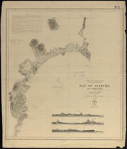
Bay of Avatcha and approaches
868.
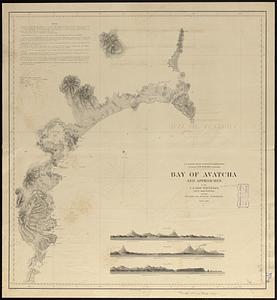
Bay of Avatcha and approaches
869.
Bay of Chaleurs
870.
Bay of Massefao, island of Tutuila ; Bay of Fagaitui, island of Tutuila ; Sketch of Aluau Bay, 1839 ; Sketch of Anuu Island, 1839
871.
Bay of Massefao, island of Tutuila ; Bay of Fagaitui, island of Tutuila ; Sketch of Aluau Bay, 1839 ; Tutuila Isld., approaches...
872.
[Bay of Seven Islands]
873.
Bay State Street Ry. Co's lines and connections
874.
The Bear Garden, the Globe Theatre
875.
La Beauce
876.
Beaufort Harbor and coast line between Charleston S.C. and Savanna Ga : with 5 mile distance lines in circles round Beaufort...
877.
Becket
878.
Becket, Mass
879.
Beddington, Surrey : plan of Croydon sewage farm
880.
Bedford Co., Pa
‹ Prev
Next ›
1
2
…
40
41
42
43
44
45
46
47
48
…
438
439


![[Bay of Seven Islands]](https://bpldcassets.blob.core.windows.net/derivatives/images/commonwealth:7h149v48t/image_thumbnail_300.jpg)


