Toggle navigation
LMEC Home
Exhibitions
Georeferencing
Tools for Teachers
Collections
My Favorites
Sign Up / Log In
Search
Search the map portal
Map Collection
Map Collection
Map Sets
Search
Search
Search for
Search In
All Fields
Creator
Title
Subject
Place
Search All Digital Collections
Advanced Search
8726 Results
My Search
Start Over
More Like
commonwealth:8049g967k
Remove constraint More Like: commonwealth:8049g967k
Filter your Search
Place
North and Central America
5,957
United States
4,865
Massachusetts
2,080
Europe
1,396
Suffolk (county)
1,046
Boston
1,019
Canada
458
Asia
438
more
Place
»
Topic
Boston (Mass.)--Maps
586
United States--Maps
282
Real property--Massachusetts--Boston--Maps
175
Massachusetts--Maps
162
Landowners--Massachusetts--Boston--Maps
133
North America--Maps--Early works to 1800
104
New England--Maps
102
Europe--Maps
79
more
Topic
»
Date
Date range begin
–
Date range end
Current results range from
1482
to
2023
View distribution
Creator
United States. Hydrographic Office
595
O.H. Bailey & Co
148
Des Barres, Joseph F. W. (Joseph Frederick Wallet), 1722-1824
123
United States. Post Office Dept
120
Ptolemy, 2nd cent
100
Walling, Henry Francis, 1825-1888
94
Geological Survey (U.S.)
86
Jefferys, Thomas, -1771
86
more
Creator
»
Format
Maps/Atlases
8,666
Manuscripts
216
Prints
56
Books
36
Objects/Artifacts
10
Drawings/Illustrations
8
Posters
5
Georeferenced
Yes
869
No
7,857
Collection
Norman B. Leventhal Map & Education Center Collection
8,701
Boston and New England Maps
2,233
Urban Maps
2,023
Maritime Charts and Atlases
1,086
American Revolutionary War-Era Maps
640
Boston Redevelopment Authority Collection
87
New York Public Library Collection
10
MacLean Collection Map Library
9
more
Collection
»
Available to use
No known restrictions
8,554
Creative Commons license
66
Search Constraints
Sort by relevance
relevance
title
date (asc)
date (desc)
Number of results to display per page
20 per page
10
per page
20
per page
50
per page
100
per page
View results as:
grid view
map view
Search Results
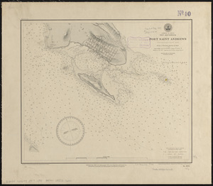
2061.
Dominion of Canada, New Brunswick, Port Saint Andrews (Passamaquoddy Bay) : from a British survey in 1844
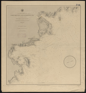
2062.
Dominion of Canada, Nova Scotia - south coast, Port Mouton and Liverpool Bay : from a British survey in 1861-62
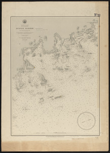
2063.
Dominion of Canada, Nova Scotia, Beaver Harbor : from a British survey in 1857
2064.
Dominion of Canada, Nova Scotia, Country Harbor : from a British survey in 1855
2065.
Dominion of Canada, Nova Scotia, Guysborough Harbor (Chedabucto Bay) : from a British survey in 1850
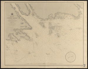
2066.
Dominion of Canada, Nova Scotia, Ship Harbor and adjacent anchorages : from a British survey in 1854
2067.
Dominion of Canada, Nova Scotia, Whitehaven : from a British survey in 1855
2068.
Dominion of Canada, Prince Edward Island, Hillsborough Bay and Charlottetown Harbor : from British surveys in 1842 & 43
2069.
Door County, Wis.
2070.
Douglas County, Wis.
2071.
Dover & Foxcroft : Piscataquis Co. Maine, 1878
2072.
Dover, Delaware : 1885
2073.
Downtown district of Manhattan
2074.
Downtown flood progression, 36 inches sea level rise
2075.
A draft of the Golden & adjacent Islands, with part of ye Isthmus of Darien as it was taken by Capt. Ienefer where ye Scots...
2076.
Drake's silver map : British Museum
2077.
A draught of Boston Harbor by Capt. Cyprian Southake
2078.
A draught of New York from the Hook to New York Town
2079.
A draught of St. John's harbour : with the soundings
2080.
A draught of the Bay of Honda
‹ Prev
Next ›
1
2
…
100
101
102
103
104
105
106
107
108
…
436
437