Toggle navigation
LMEC Home
Exhibitions
Georeferencing
Tools for Teachers
Collections
My Favorites
Sign Up / Log In
Search
Search the map portal
Map Collection
Map Collection
Map Sets
Search
Search
Search for
Search In
All Fields
Creator
Title
Subject
Place
Search All Digital Collections
Advanced Search
8711 Results
My Search
Start Over
More Like
commonwealth:8049g902r
Remove constraint More Like: commonwealth:8049g902r
Filter your Search
Place
North and Central America
5,942
United States
4,859
Massachusetts
2,079
Europe
1,396
Suffolk (county)
1,046
Boston
1,019
Canada
449
Asia
438
more
Place
»
Topic
Boston (Mass.)--Maps
586
United States--Maps
282
Real property--Massachusetts--Boston--Maps
175
Massachusetts--Maps
162
Landowners--Massachusetts--Boston--Maps
133
North America--Maps--Early works to 1800
103
New England--Maps
102
Europe--Maps
79
more
Topic
»
Date
Date range begin
–
Date range end
Current results range from
1482
to
2023
View distribution
Creator
United States. Hydrographic Office
595
O.H. Bailey & Co
148
Des Barres, Joseph F. W. (Joseph Frederick Wallet), 1722-1824
124
United States. Post Office Dept
120
Ptolemy, 2nd cent
100
Walling, Henry Francis, 1825-1888
94
Geological Survey (U.S.)
86
Jefferys, Thomas, -1771
85
more
Creator
»
Format
Maps/Atlases
8,651
Manuscripts
220
Prints
56
Books
36
Objects/Artifacts
10
Drawings/Illustrations
8
Posters
5
Georeferenced
Yes
870
No
7,841
Collection
Norman B. Leventhal Map & Education Center Collection
8,694
Boston and New England Maps
2,233
Urban Maps
2,023
Maritime Charts and Atlases
1,083
American Revolutionary War-Era Maps
632
Boston Redevelopment Authority Collection
87
Richard H. Brown Revolutionary War Map Collection at Mount Vernon
5
Library of Congress Collection
4
more
Collection
»
Available to use
No known restrictions
8,552
Creative Commons license
60
Search Constraints
Sort by relevance
relevance
title
date (asc)
date (desc)
Number of results to display per page
20 per page
10
per page
20
per page
50
per page
100
per page
View results as:
grid view
map view
Search Results
2201.
The estate of the Brookline Land Company : June 20, 1860
2202.
États Unis
2203.
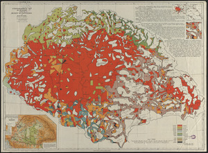
Ethnographical map of Hungary based on the density of population
2204.
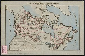
Ethnographische karte von Britisch America : verbreitung der indianer
2205.
Europ, and the cheife cities contayned therin, described; with the habits of most kingdoms now in use
2206.
Europa : teatro de operaciones de los ejercitos beligerantes
2207.
Europa
2208.
Europa exactissime descripta
2209.
Europae
2210.
Europae
2211.
Das Europäische Russland
2212.
Europam sive Celticam veterem
2213.
Europe
2214.
Europe
2215.
Europe
2216.
Europe : a pictorial map
2217.
Europe
2218.
Europe
2219.
Europe, Africa and the Far East
2220.
L'Europe de 1914
‹ Prev
Next ›
1
2
…
107
108
109
110
111
112
113
114
115
…
435
436