Toggle navigation
LMEC Home
Exhibitions
Georeferencing
Tools for Teachers
Collections
My Favorites
Sign Up / Log In
Search
Search the map portal
Map Collection
Map Collection
Map Sets
Search
Search
Search for
Search In
All Fields
Creator
Title
Subject
Place
Search All Digital Collections
Advanced Search
8940 Results
My Search
Start Over
More Like
commonwealth:8049g889d
Remove constraint More Like: commonwealth:8049g889d
Filter your Search
Place
North and Central America
6,111
United States
4,937
Massachusetts
2,083
Europe
1,396
Suffolk (county)
1,046
Boston
1,019
Canada
507
Asia
441
more
Place
»
Topic
Boston (Mass.)--Maps
586
United States--Maps
282
North America--Maps--Early works to 1800
240
Real property--Massachusetts--Boston--Maps
175
Massachusetts--Maps
162
Landowners--Massachusetts--Boston--Maps
133
New England--Maps
102
New England--Maps--Early works to 1800
97
more
Topic
»
Date
Date range begin
–
Date range end
Current results range from
1482
to
2023
View distribution
Creator
United States. Hydrographic Office
595
O.H. Bailey & Co
148
Des Barres, Joseph F. W. (Joseph Frederick Wallet), 1722-1824
123
United States. Post Office Dept
120
Ptolemy, 2nd cent
100
Jefferys, Thomas, -1771
96
Walling, Henry Francis, 1825-1888
94
Sayer, Robert, 1725-1794
88
more
Creator
»
Format
Maps/Atlases
8,880
Manuscripts
220
Prints
56
Books
36
Objects/Artifacts
10
Drawings/Illustrations
8
Posters
5
Georeferenced
Yes
876
No
8,064
Collection
Norman B. Leventhal Map & Education Center Collection
8,728
Boston and New England Maps
2,244
Urban Maps
2,023
Maritime Charts and Atlases
1,086
American Revolutionary War-Era Maps
818
MacLean Collection Map Library
102
Boston Redevelopment Authority Collection
87
New York Public Library Collection
36
more
Collection
»
Available to use
No known restrictions
8,559
Creative Commons license
150
Search Constraints
Sort by relevance
relevance
title
date (asc)
date (desc)
Number of results to display per page
20 per page
10
per page
20
per page
50
per page
100
per page
View results as:
grid view
map view
Search Results
5681.
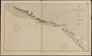
North America, west coast of Central America, Ocos River to San Juan del Sur
5682.
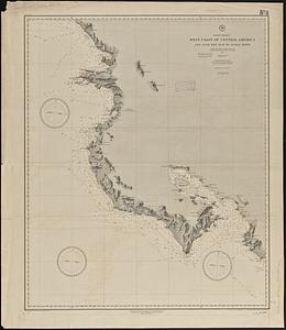
North America, west coast of Central America, San Juan del Sur to Judas Point
5683.
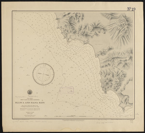
North America, west coast of lower California, Blanca and Falsa Bays : from a survey in 1887 by the officers of the U.S.S....
5684.
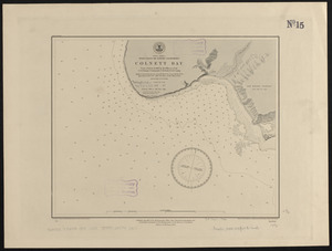
North America, west coast of lower California, Colnett Bay : from a survey in 1886 by the officers of the U.S.S. Ranger,...
5685.
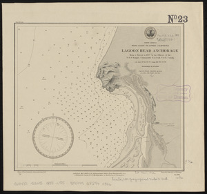
North America, west coast of lower California, Lagoon Head Anchorage : from a survey in 1887 by the officers of the U.S.S....
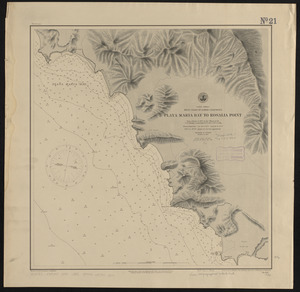
5686.
North America, west coast of lower California, Playa Maria Bay to Rosalia Point : from a survey in 1887 by the officers of the...
5687.
North America, west coast of lower California, Rosario Bay and Sacramento Reef : from a survey in 1887 by the officers of the...
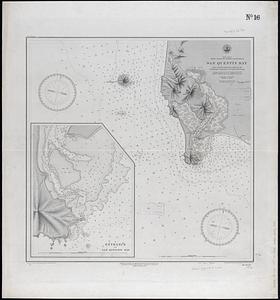
5688.
North America, west coast of lower California, San Quentin Bay : from a survey in 1886 by the officers of the U.S.S. Ranger,...
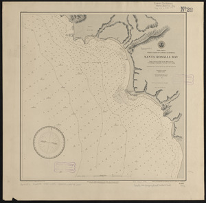
5689.
North America, west coast of lower California, Santa Rosalia Bay : from a survey in 1887 by the officers of the U.S.S. Ranger,...
5690.
North America, west coast of lower California, Soledad Bay and Santo Tomas Anchorage : from a survey in 1886 by the officers of...
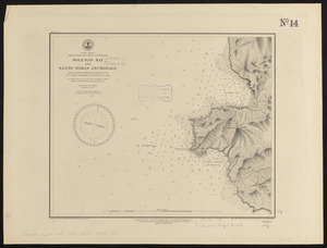
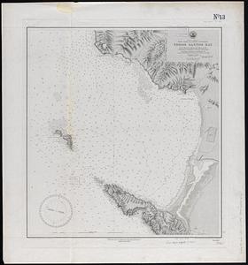
5691.
North America, west coast of lower California, Todos Santos Bay : from a survey in 1886 by the officers of the U.S.S. Ranger,...
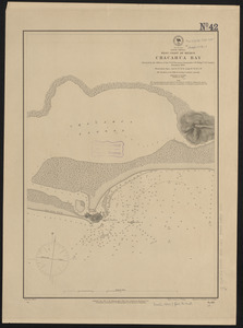
5692.
North America, west coast of Mexico, Chacahua Bay
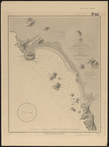
5693.
North America, west coast of Mexico, Chamela Bay
5694.
North America, west coast of Mexico, Chamela Bay to Maldonado : surveyed by the officers of the U.S.S. Tuscarora in 1878-9 and...
5695.
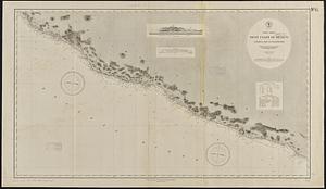
North America, west coast of Mexico, eastern shore of the Gulf of California, harbor of Altata
5696.
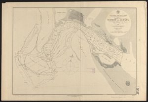
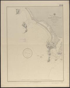
North America, west coast of Mexico, harbor of Mazatlan : from British surveys in 1828 & 1863 corrected for the latest information
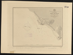
5697.
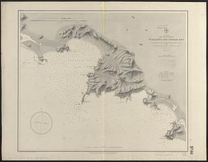
North America, west coast of Mexico, Port San Blas : from a British survey in 1822, corrected for the latest information, 1887
5698.
North America, west coast of Mexico, Tenacatita and Navidad Bays : surveyed by the officers of the U.S.S. Ranger, Commander...
5699.
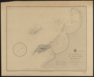
North America, west coast of Newfoundland, Cow Head Harbor and White Rock Bay : from French surveys in 1857 & 1881
5700.
North America, west coast, ports on the west coast of Lower California : from British surveys in 1847, with additions by Comdr....
‹ Prev
Next ›
1
2
…
281
282
283
284
285
286
287
288
289
…
446
447