Toggle navigation
LMEC Home
Exhibitions
Georeferencing
Tools for Teachers
Collections
My Favorites
Sign Up / Log In
Search
Search the map portal
Map Collection
Map Collection
Map Sets
Search
Search
Search for
Search In
All Fields
Creator
Title
Subject
Place
Search All Digital Collections
Advanced Search
8709 Results
My Search
Start Over
More Like
commonwealth:7h149z785
Remove constraint More Like: commonwealth:7h149z785
Filter your Search
Place
North and Central America
5,940
United States
4,858
Massachusetts
2,078
Europe
1,396
Suffolk (county)
1,060
Boston
1,033
Canada
449
Asia
438
more
Place
»
Topic
Boston (Mass.)--Maps
586
United States--Maps
282
Real property--Massachusetts--Boston--Maps
175
Massachusetts--Maps
162
Landowners--Massachusetts--Boston--Maps
133
North America--Maps--Early works to 1800
103
New England--Maps
102
Europe--Maps
79
more
Topic
»
Date
Date range begin
–
Date range end
Current results range from
1482
to
2023
View distribution
Creator
United States. Hydrographic Office
595
O.H. Bailey & Co
148
Des Barres, Joseph F. W. (Joseph Frederick Wallet), 1722-1824
123
United States. Post Office Dept
120
Ptolemy, 2nd cent
100
Walling, Henry Francis, 1825-1888
94
Geological Survey (U.S.)
86
Jefferys, Thomas, -1771
85
more
Creator
»
Format
Maps/Atlases
8,634
Manuscripts
227
Prints
59
Books
36
Drawings/Illustrations
20
Objects/Artifacts
10
Posters
5
Georeferenced
Yes
869
No
7,840
Collection
Norman B. Leventhal Map & Education Center Collection
8,694
Boston and New England Maps
2,233
Urban Maps
2,023
Maritime Charts and Atlases
1,082
American Revolutionary War-Era Maps
630
Boston Redevelopment Authority Collection
87
Richard H. Brown Revolutionary War Map Collection at Mount Vernon
8
British Library Collection
7
Available to use
No known restrictions
8,552
Creative Commons license
62
Search Constraints
Sort by relevance
relevance
title
date (asc)
date (desc)
Number of results to display per page
20 per page
10
per page
20
per page
50
per page
100
per page
View results as:
grid view
map view
Search Results
1.
A view of Boston from Dorchester neck : Long Island open on the north side of Nicks Mate Island ; Boston from Willis Creek
2.
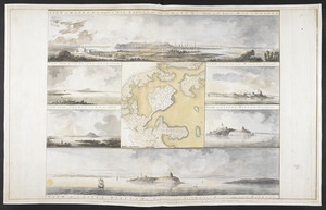
Cape Poge bearing S 52°E, distant 2 miles : Sandy Point bearing W S W distant four miles ; Gay Head bearing N E 1/4 E and...
3.
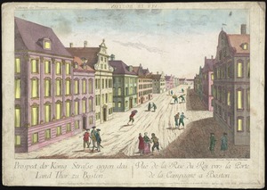
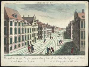
Prospect der König Strasse gegen das land thor zu Boston = Vuë de la Rue du Roi vers la porte de la campagne a Boston
4.
A view of Boston taken on the road to Dorchester
5.
[Boston Neck, with the British lines and John Hancock's house]
6.
[Cambridge with Washington's headquarters]
7.
[Charlestown Promontory, the ruins of the town after the Battle of Bunker Hill and General Howe's encampment]
8.
[Dorchester Neck]
9.
[Noddle Island and the Mill Pond]
10.
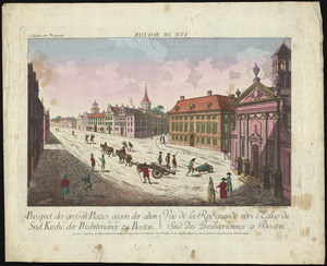
Prospect der grossen plazes gegn der alten Sud Kirche der Presbiterianer zu Boston = : Vuë de la Rue grande vers l'Eglise du...
11.
Prospect der König Strasse gegen das land thor zu Boston = : Vuë de la Rue du Roi vers la porte de la campagne a Boston
12.
VIEW of BOSTON the Capital of NEW ENGLAND from Col. HATCH's House on the Road to DORCHESTER = VIEW FROM DORCHESTER NECK = VIEW...
13.
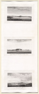
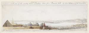
A View of the country round Boston taken from Beacon hill : shewing the Lines, Ridouts & Different Encampments of the Rebels...
14.
[View of the country round Boston taken from Beacon hill]
15.
[View of the country round Boston taken from Beacon hill]
16.
[View of the country round Boston taken from Beacon hill]
17.
[View of the country round Boston taken from Beacon hill]
18.
[View of the country round Boston taken from Beacon hill]
19.
The 100th anniversary map of Abraham Lincoln's visit to Massachusetts, September 11-23, 1848
20.
1630 shoreline
‹ Prev
Next ›
1
2
3
4
5
…
435
436


![[Boston Neck, with the British lines and John Hancock's house]](https://bpldcassets.blob.core.windows.net/derivatives/images/commonwealth:dz010v61c/image_thumbnail_300.jpg)
![[Cambridge with Washington's headquarters]](https://bpldcassets.blob.core.windows.net/derivatives/images/commonwealth:dz010v63x/image_thumbnail_300.jpg)
![[Charlestown Promontory, the ruins of the town after the Battle of Bunker Hill and General Howe's encampment]](https://bpldcassets.blob.core.windows.net/derivatives/images/commonwealth:dz010v65g/image_thumbnail_300.jpg)
![[Dorchester Neck]](https://bpldcassets.blob.core.windows.net/derivatives/images/commonwealth:dz010v59b/image_thumbnail_300.jpg)
![[Noddle Island and the Mill Pond]](https://bpldcassets.blob.core.windows.net/derivatives/images/commonwealth:dz010v671/image_thumbnail_300.jpg)
![[View of the country round Boston taken from Beacon hill]](https://bpldcassets.blob.core.windows.net/derivatives/images/commonwealth:6108vv93v/image_thumbnail_300.jpg)
![[View of the country round Boston taken from Beacon hill]](https://bpldcassets.blob.core.windows.net/derivatives/images/commonwealth:6108vv97z/image_thumbnail_300.jpg)
![[View of the country round Boston taken from Beacon hill]](https://bpldcassets.blob.core.windows.net/derivatives/images/commonwealth:6108vv95d/image_thumbnail_300.jpg)
![[View of the country round Boston taken from Beacon hill]](https://bpldcassets.blob.core.windows.net/derivatives/images/commonwealth:6108vv99h/image_thumbnail_300.jpg)
![[View of the country round Boston taken from Beacon hill]](https://bpldcassets.blob.core.windows.net/derivatives/images/commonwealth:6108vw01b/image_thumbnail_300.jpg)

