[View of the country round Boston taken from Beacon hill]
![[View of the country round Boston taken from Beacon hill]](https://bpldcassets.blob.core.windows.net/derivatives/images/commonwealth:6108vv97z/image_access_800.jpg)
This map is also available in American Revolutionary Geographies Online (ARGO), a collections portal especially built for material relating to the American Revolutionary War Era. Visit ARGO to learn more about this item and explore the historical geography of North America in the late eighteenth century.
Item Information
- Title:
- [View of the country round Boston taken from Beacon hill]
- Description:
-
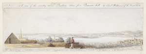
View from Boston looking north, with Royal Irish camp, steeple of Old North Church (Christ Church) and rooftops of North Boston in the foreground, HMS Symmetry sailing on Charles River beyond, and rebel redoubts, enemy lines and camps, Charlestown, Bunker Hill, General Howe's camp and Mystic River seen across the river in the background
Richard Williams, a British lieutenant stationed in Boston during the siege, created these watercolor landscapes of the Boston countryside. In his journal, he described Boston as "well built." But he observed that Boston suffered from neglect and had "grass growing in every street." Williams drew five landscape views providing a panoramic perspective from Beacon Hill. The fourth scene features North Boston with the ruins of Charlestown, which burned during the Battle of Bunker Hill.
- Artist:
- Williams, Richard, active 1750-1776
- Former owner:
- George, III, King of Great Britain, 1738-1820
- Donor:
- George, IV, King of Great Britain, 1762-1830
- Date:
-
[1775?]
- Format:
-
Drawings/Illustrations
Manuscripts
- Genre:
-
Views
- Location:
- British Library
- Collection (local):
-
British Library Collection
- Subjects:
-
Sieges--Massachusetts--Boston--Pictorial works--Early works to 1800
Boston (Mass.)--Pictorial works--Early works to 1800
- Places:
-
Suffolk (county)Boston
- Extent:
- 1 drawing : ink and watercolour ; sheet 17 x 48 cm
- Terms of Use:
-
No known copyright restrictions.
This work is licensed for use under a Creative Commons Attribution Non-Commercial Share Alike License (CC BY-NC-SA).

- Language:
-
English
- Catalog Record:
-
http://explore.bl.uk/BLVU1:LSCOP-ALL:BLL01016556887
- Notes:
-
Key below.
Titled ‘A drawn View of the Country round Boston, taken from Beacon Hill: by Lieut. Williams, in six pieces’ in the Catalogue of the Maps, Prints, Drawings, etc., forming the geographical and topographical collection attached to the Library of his late Majesty King George the third, etc., London, 1829.
Titled 'A colored panoramic "view of the country round Boston, taken from Beacon Hill; by Lieut. Richard Williams, of the Royal Welsh Fuziliers, shewing the lines, redoubts, and different encampments of the rebels; also those of his Majesty's troops under the command of H.E. Lieut.-Gen. Gage, Governor of Massachusett's Bay, &c.;" dedicated to Col. James of the Royal Artillery' in the Catalogue of the manuscript maps, charts, and plans, and of the topographical drawings in the British Museum, London, 1844-1861.
No. 4 of six sheets individually numbered by the artist, depicting the area around Boston as seen from the city during the siege after the Battle of Bunker Hill (June 1775). Signed with initials on plate no. 4: 'R.W.f:'. Title on plate no. 1 and dedication and production details on plates no. 2-4: 'shewing the Lines, Ridouts & Different Encampments of the Rebels also those of his Majesty's Troops under the command of his Excellency Lieut. General Gage, Governor of Massachuset's Bay &c &c. These Drawings are most humbly inscribed to Colonel James of the Royal Artillery by his obliged Servant R.d Williams'.
Watermark: Fleur-de-lys within coat of arms.
Copy at Maps K.Top.120.38.e. Exhibited: "The American War of Independence, 1775-84: a commemorative exhibition organized by the Map Library and the Department of Manuscripts of the British Library Reference Division", The British Library, London, 4 July 1975 – 11 November 1975. Uk
- Notes (exhibitions):
-
Exhibited: "We Are One: Mapping America's Road from Revolution to Independence" organized by the Norman B. Leventhal Map Center at the Boston Public Library, 2015.

![[View of the country round Boston taken from Beacon hill]](https://bpldcassets.blob.core.windows.net/derivatives/images/commonwealth:6108vv93v/image_thumbnail_300.jpg)
![[View of the country round Boston taken from Beacon hill]](https://bpldcassets.blob.core.windows.net/derivatives/images/commonwealth:6108vv95d/image_thumbnail_300.jpg)
![[View of the country round Boston taken from Beacon hill]](https://bpldcassets.blob.core.windows.net/derivatives/images/commonwealth:6108vv99h/image_thumbnail_300.jpg)
